
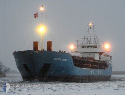
WILSON GHENT
General Cargo
Current Trip
REYKJAVIK
| Time Travelled | 6 h, 20 mins |
|---|---|
| Remaining Time | --- |
| Distance Travelled | 54.98 nm |
| Remaining Distance | --- |
| AVG Speed | 9.7 Knop |
| MAX Speed | 11 Knop |
| AVG Wind | 16.3 knots |
| MAX Wind | 18 knots |
| MIN Temp | 8.5°C / 47.3°F |
| MAX Temp | 9.1°C / 48.38°F |
| Djupgående | 6.1 m |
| Position mottagen | 6 d sen |
Current Position
| Longitud | -4.70327° |
|---|---|
| Latitude | 60.65541° |
| Status | Under way using engine |
| Fart | 8.7 Knop |
| Kurs | 285.3° |
| Område | North Atlantic Ocean |
| Station | T-AIS |
| Position mottagen | 6 d sen |
Info
Information
The current position of WILSON GHENT is in North Atlantic Ocean with coordinates 60.65541° / -4.70327° as reported on 2024-09-01 15:49 by AIS to our vessel tracker app. The vessel's current speed is 8.7 Knop
The vessel WILSON GHENT (IMO: 9150236, MMSI: 314548000) is a General Cargo that was built in 1996 ( 28 År gammal ). It's sailing under the flag of [BB] Barbados.
In this page you can find informations about the vessels current position, last detected port calls, and current voyage information. If the vessels is not in coverage by AIS you will find the latest position.
The current position of WILSON GHENT is detected by our AIS receivers and we are not responsible for the reliability of the data. The last position was recorded while the vessel was in Coverage by the Ais receivers of our vessel tracking app.
The current draught of WILSON GHENT as reported by AIS is 6.1 meters
Weather
| Temperature | 8.5°C / 47.3°F |
|---|---|
| Wind Speed | 16 knots |
| Direction | 279° W |
| Pressure | 999.5 hPa |
| Humidity | 69.7 % |
| Cloud Coverage | 60 % |
Featured Company
Last Port Calls
| Port | Arrival | Departure | Time In Port |
|---|---|---|---|
| 2024-09-05 10:24 | 2024-09-07 20:58 | 2 d | |
| 2024-08-28 06:54 | 2024-08-29 16:28 | 1 d | |
| 2024-08-22 14:49 | 2024-08-27 13:35 | 4 d | |
| 2024-08-14 21:14 | 2024-08-14 21:50 | 35 m | |
| 2024-08-13 14:52 | 2024-08-13 15:32 | 39 m | |
| 2024-08-02 16:14 | 2024-08-05 21:41 | 3 d | |
| 2024-07-25 20:51 | 2024-07-27 14:57 | 1 d | |
| 2024-07-20 20:39 | 2024-07-24 22:53 | 4 d | |
| 2024-07-14 18:18 | 2024-07-17 02:36 | 2 d |
Last Trips
| Origin | Departure | Destination | Arrival | Distance | |
|---|---|---|---|---|---|
| 2024-08-29 16:28 | 2024-09-05 10:24 | 1316.16 nm | |||
| 2024-08-27 13:35 | 2024-08-28 06:54 | 177.21 nm | |||
| 2024-08-14 21:50 | 2024-08-22 14:49 | 1922.87 nm | |||
| 2024-08-13 15:32 | 2024-08-14 21:14 | 1.85 nm | |||
| 2024-08-05 21:41 | 2024-08-13 14:52 | 261.75 nm | |||
| 2024-07-27 14:57 | 2024-08-02 16:14 | 1457.67 nm | |||
| 2024-07-24 22:53 | 2024-07-25 20:51 | 253.15 nm | |||
| 2024-07-17 02:36 | 2024-07-20 20:39 | 803.30 nm | |||
| 2024-06-21 01:22 | 2024-07-14 18:18 | 1255.89 nm |
Events
| Tid | Event | Detaljer | Position / Dest | Information |
|---|---|---|---|---|
| 2024-09-07 20:58 | AVGÅTT HAMN |
|
64.19661 / -21.94487
REYKJAVIK
|
Fart: Kurs: 246° |
| 2024-09-05 10:55 | STOPPAR förflyttning |
64.15118 / -21.85861
[IS] REYKJAVIK
|
Fart: Kurs: 245° |
|
| 2024-09-05 10:24 | ANLÄNDER HAMN |
|
64.15254 / -21.85363
[IS] REYKJAVIK
|
Fart: 3.4 kn Kurs: 140° |
| 2024-09-05 09:54 | STARTAR förflyttning | 2.6 nm, North of REYKJAVIK |
64.19333 / -21.90490
REYKJAVIK
|
Fart: 4.3 kn Kurs: 145° |
| 2024-09-04 09:54 | STOPPAR förflyttning | 3.54 nm, North of REYKJAVIK |
64.20873 / -21.90997
REYKJAVIK
|
Fart: 0.2 kn Kurs: 113° |
| 2024-09-01 15:55 | Status ändrad | Default Under way using engine |
60.65957 / -4.73217
REYKJAVIK
|
Fart: 8.7 kn Kurs: 285.3° |
| 2024-09-01 15:49 | Status ändrad | Under way using engine Default |
60.65541 / -4.70327
REYKJAVIK
|
Fart: 8.9 kn Kurs: 287° |
| 2024-09-01 15:49 | UTANFÖR täckningsområde |
60.65541 / -4.70327
North Atlantic Ocean
REYKJAVIK
|
Fart: 8.7 kn Kurs: 285.3° |
|
| 2024-09-01 15:39 | Status ändrad | Default Under way using engine |
60.64891 / -4.65579
REYKJAVIK
|
Fart: 8.5 kn Kurs: 283.8° |
| 2024-09-01 15:31 | Upptäckt i hav | Faeroe Islands part of the North Atlantic Ocean |
60.64407 / -4.61962
North Atlantic Ocean
REYKJAVIK
|
Fart: 8.5 kn Kurs: 283.8° |