
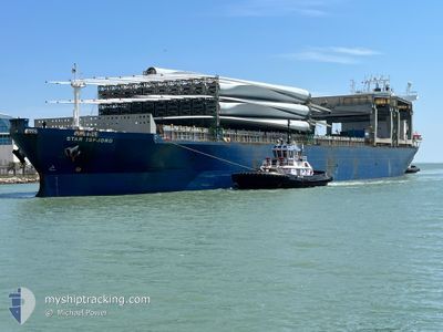
STAR ISFJORD
General Cargo
Current Trip
| Trip Time | 15 h, 48 mins |
|---|---|
| Trip Distance | 144.23 nm |
| AVG Speed | 7.4 Knop |
| MAX Speed | 13.2 Knop |
| Djupgående | 8 m |
| AVG Wind | 21.6 knots |
| MAX Wind | 25.7 knots |
| MIN Temp | 1.9°C / 35.42°F |
| MAX Temp | 6.7°C / 44.06°F |
| Position mottagen | 3 d sen |
Current Position
| Longitud | --- |
|---|---|
| Latitude | --- |
| Status | Under way using engine |
| Fart | 10.7 Knop |
| Kurs | 65.1° |
| Område | Skaggerak |
| Station | T-AIS |
| Position mottagen | 3 d sen |
Info
Information
The current position of STAR ISFJORD is in Skaggerak with coordinates 58.31791° / 11.80872° as reported on 2024-12-20 10:25 by AIS to our vessel tracker app. The vessel's current speed is 10.7 Knop and is currently inside the port of UDDEVALLA.
The vessel STAR ISFJORD (IMO: 9182978, MMSI: 257615000) is a General Cargo that was built in 2000 ( 24 År gammal ). It's sailing under the flag of [NO] Norway.
In this page you can find informations about the vessels current position, last detected port calls, and current voyage information. If the vessels is not in coverage by AIS you will find the latest position.
The current position of STAR ISFJORD is detected by our AIS receivers and we are not responsible for the reliability of the data. The last position was recorded while the vessel was in Coverage by the Ais receivers of our vessel tracking app.
The current draught of STAR ISFJORD as reported by AIS is 8 meters
Weather
| Temperature | 5.7°C / 42.26°F |
|---|---|
| Wind Speed | 7 knots |
| Direction | 226° SW |
| Pressure | 983.5 hPa |
| Humidity | 82.9 % |
| Cloud Coverage | 100 % |
Featured Company
Last Port Calls
| Port | Arrival | Departure | Time In Port |
|---|---|---|---|
| 2024-12-20 10:44 | |||
| 2024-12-19 00:06 | 2024-12-19 18:56 | 18 h | |
| 2024-12-15 22:56 | 2024-12-18 23:55 | 3 d | |
| 2024-12-09 23:19 | 2024-12-11 22:51 | 1 d | |
| 2024-12-02 06:42 | 2024-12-05 20:34 | 3 d | |
| 2024-11-29 10:56 | 2024-12-02 01:22 | 2 d | |
| 2024-11-07 07:37 | 2024-11-11 12:12 | 4 d | |
| 2024-10-28 20:54 | 2024-10-30 12:54 | 1 d | |
| 2024-10-04 13:43 | 2024-10-07 20:55 | 3 d | |
| 2024-10-02 01:19 |
Last Trips
| Origin | Departure | Destination | Arrival | Distance | |
|---|---|---|---|---|---|
| 2024-12-19 19:56 | 2024-12-20 11:44 | 144.23 nm | |||
| 2024-12-19 00:55 | 2024-12-19 01:06 | 0.28 nm | |||
| 2024-12-11 23:51 | 2024-12-15 23:56 | 538.87 nm | |||
| 2024-12-05 20:34 | 2024-12-10 00:19 | 698.80 nm | |||
| 2024-11-11 09:12 | 2024-12-02 06:42 | 5298.98 nm | |||
| 2024-11-11 09:12 | 2024-11-29 10:56 | 5237.81 nm | |||
| 2024-10-30 09:54 | 2024-11-07 04:37 | 619.25 nm | |||
| 2024-10-07 15:55 | 2024-10-28 17:54 | 6120.78 nm | |||
| 2024-10-01 20:19 | 2024-10-04 08:43 | 750.94 nm |
Events
| Tid | Event | Detaljer | Position / Dest | Information |
|---|---|---|---|---|
| 2024-12-20 10:44 | ANLÄNDER HAMN |
|
58.34820 / 11.90052
[SE] UDDEVALLA
|
Fart: 10.7 kn Kurs: 65.1° |
| 2024-12-20 10:25 | UTANFÖR täckningsområde |
58.31791 / 11.80872
Skaggerak
SEUDD
|
Fart: 10.7 kn Kurs: 65.1° |
|
| 2024-12-20 08:28 | Byter havsområde | Swedish part of the Skaggerak Swedish part of the Kattegat |
58.03210 / 11.78699
Skaggerak
SEUDD
|
Fart: 9.1 kn Kurs: 15° |
| 2024-12-20 04:52 | Byter havsområde | Swedish part of the Kattegat Swedish part of the Skaggerak |
57.85607 / 11.21912
Kattegat
SEUDD
|
Fart: 3.7 kn Kurs: 182.2° |
| 2024-12-19 22:58 | Byter havsområde | Swedish part of the Skaggerak Norwegian part of the Skaggerak |
58.57701 / 10.27350
Skaggerak
SEUDD
|
Fart: 9.6 kn Kurs: 143.4° |
| 2024-12-19 20:10 | ETA ändrat | 2024/12/20 06:30 2024/12/20 07:00 |
58.96271 / 9.76884
SEUDD
|
Fart: 8.8 kn Kurs: 152.6° |
| 2024-12-19 18:56 | AVGÅTT HAMN |
|
59.11475 / 9.61645
SEUDD
|
Fart: 4.1 kn Kurs: 149° |
| 2024-12-19 18:54 | STARTAR förflyttning |
59.11727 / 9.61353
[NO] PORSGRUNN
|
Fart: 4.1 kn Kurs: 149° |
|
| 2024-12-19 18:25 | Status ändrad | Under way using engine Moored |
59.12226 / 9.61523
[NO] PORSGRUNN
|
Fart: Kurs: 30° |
| 2024-12-19 17:46 | Djupgående ändrat | 8 7.2 |
59.12231 / 9.61535
[NO] PORSGRUNN
|
Fart: Kurs: 30° |