
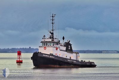
RACHELEBRUSCO
Tug
Current Trip
XX XXX>US^0TH6
| Time Travelled | 17 h, 21 mins |
|---|---|
| Remaining Time | --- |
| Distance Travelled | 59.59 nm |
| Remaining Distance | --- |
| AVG Speed | 5.2 Knots |
| MAX Speed | 8.5 Knots |
| AVG Wind | 5.6 knots |
| MAX Wind | 14.2 knots |
| MIN Temp | 6.5°C / 43.7°F |
| MAX Temp | 11°C / 51.8°F |
| Draught | 0 m |
| Position Received | 1 d ago |
Current Position
| Longitude | --- |
|---|---|
| Latitude | --- |
| Status | Under way using engine |
| Speed | 2 Knots |
| Course | 71° |
| Area | North Pacific Ocean |
| Station | T-AIS |
| Position Received | 1 d ago |
Info
Information
The current position of RACHELEBRUSCO is in North Pacific Ocean with coordinates 46.91629° / -124.12634° as reported on 2025-12-04 09:36 by AIS to our vessel tracker app. The vessel's current speed is 2 Knots
The vessel RACHELEBRUSCO (IMO: 7101827, MMSI: 367002210) is a Tug that was built in 1971 ( 54 years old ). It's sailing under the flag of [US] USA.
In this page you can find informations about the vessels current position, last detected port calls, and current voyage information. If the vessels is not in coverage by AIS you will find the latest position.
The current position of RACHELEBRUSCO is detected by our AIS receivers and we are not responsible for the reliability of the data. The last position was recorded while the vessel was in Coverage by the Ais receivers of our vessel tracking app.
Weather
| Temperature | 10.1°C / 50.18°F |
|---|---|
| Wind Speed | 3 knots |
| Direction | 153° SSE |
| Pressure | 1016.3 hPa |
| Humidity | 99.3 % |
| Cloud Coverage | 100 % |
Featured Company
Last Port Calls
| Port | Arrival | Departure | Time In Port |
|---|---|---|---|
| 2025-12-04 11:26 | 2025-12-04 12:07 | 40 m | |
| 2025-12-03 11:31 | 2025-12-03 12:15 | 44 m | |
| 2025-12-03 05:15 | 2025-12-03 05:47 | 31 m | |
| 2025-12-02 15:43 | 2025-12-02 16:15 | 32 m | |
| 2025-12-02 10:03 | 2025-12-02 10:43 | 40 m | |
| 2025-12-01 19:47 | 2025-12-01 20:23 | 36 m | |
| 2025-12-01 13:07 | 2025-12-01 13:31 | 24 m | |
| 2025-11-30 13:22 | 2025-11-30 16:00 | 2 h | |
| 2025-10-31 08:15 | 2025-11-30 11:35 | ||
| 2025-10-31 07:21 | 2025-10-31 07:41 | 19 m |
Last Trips
| Origin | Departure | Destination | Arrival | Distance | |
|---|---|---|---|---|---|
| 2025-12-03 12:15 | 2025-12-04 11:26 | 107.54 nm | |||
| 2025-12-03 05:47 | 2025-12-03 11:31 | 25.67 nm | |||
| 2025-12-02 16:15 | 2025-12-03 05:15 | 57.74 nm | |||
| 2025-12-02 10:43 | 2025-12-02 15:43 | 25.64 nm | |||
| 2025-12-01 20:23 | 2025-12-02 10:03 | 57.32 nm | |||
| 2025-12-01 13:31 | 2025-12-01 19:47 | 28.76 nm | |||
| 2025-11-30 16:00 | 2025-12-01 13:07 | 97.63 nm | |||
| 2025-11-30 11:35 | 2025-11-30 13:22 | 21.91 nm | |||
| 2025-10-31 07:41 | 2025-10-31 08:15 | 5.07 nm | |||
| 2025-10-27 10:00 | 2025-10-31 07:21 | 438.89 nm |
Events
| Time | Event | Details | Position / Dest | Info |
|---|---|---|---|---|
| 2025-12-04 20:07 | PORT DEPARTURE |
|
46.96684 / -123.86475
XX XXX>US^0TH6
|
Speed: 3.8 kn Course: 300° |
| 2025-12-04 19:47 | START Moving |
46.96022 / -123.83670
[US] ABERDEEN
|
Speed: 3.3 kn Course: 258° |
|
| 2025-12-04 19:35 | STOP Moving |
46.96146 / -123.82989
[US] ABERDEEN
|
Speed: Course: 63° |
|
| 2025-12-04 19:26 | PORT ARRIVAL |
|
46.96147 / -123.82990
[US] ABERDEEN
|
Speed: 5.3 kn Course: 100° |
| 2025-12-04 09:43 | Status Changed | Default Under way using engine |
46.91778 / -124.12064
XX XXX>US^0TH6
|
Speed: 2 kn Course: 71° |
| 2025-12-04 09:36 | OUT of Coverage |
46.91629 / -124.12634
North Pacific Ocean
|
Speed: 2 kn Course: 74.5° |
|
| 2025-12-04 09:29 | Status Changed | Under way using engine Default |
46.91713 / -124.12869
XX XXX>US^0TH6
|
Speed: 3.4 kn Course: 248° |
| 2025-12-04 09:27 | IN Coverage |
46.91710 / -124.12880
North Pacific Ocean
|
Speed: 3.6 kn Course: 251.9° |
|
| 2025-12-04 04:07 | Status Changed | Default Under way using engine |
46.91971 / -124.11368
XX XXX>US^0TH6
|
Speed: 4.3 kn Course: 81° |
| 2025-12-04 04:00 | OUT of Coverage |
46.91785 / -124.12906
North Pacific Ocean
|
Speed: 4.3 kn Course: 80.3° |