
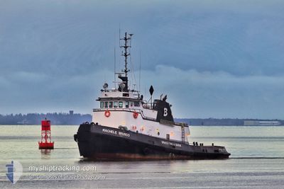
RACHELEBRUSCO
Tug
Current Trip
XX XXX>US^0TH6
| Time Travelled | 5 h, 25 mins |
|---|---|
| Remaining Time | --- |
| Distance Travelled | 24.00 nm |
| Remaining Distance | --- |
| AVG Speed | 5.3 Knop |
| MAX Speed | 7.5 Knop |
| AVG Wind | 19.3 knots |
| MAX Wind | 22 knots |
| MIN Temp | 11°C / 51.8°F |
| MAX Temp | 12.8°C / 55.04°F |
| Djupgående | 0 m |
| Position mottagen | 1 d sen |
Current Position
| Longitud | --- |
|---|---|
| Latitude | --- |
| Status | Under way using engine |
| Fart | 5.4 Knop |
| Kurs | 271.7° |
| Område | North Pacific Ocean |
| Station | T-AIS |
| Position mottagen | 1 d sen |
Info
Information
The current position of RACHELEBRUSCO is in North Pacific Ocean with coordinates 46.96817° / -123.89427° as reported on 2025-12-07 19:37 by AIS to our vessel tracker app. The vessel's current speed is 5.4 Knop
The vessel RACHELEBRUSCO (IMO: 7101827, MMSI: 367002210) is a Tug that was built in 1971 ( 54 År gammal ). It's sailing under the flag of [US] USA.
In this page you can find informations about the vessels current position, last detected port calls, and current voyage information. If the vessels is not in coverage by AIS you will find the latest position.
The current position of RACHELEBRUSCO is detected by our AIS receivers and we are not responsible for the reliability of the data. The last position was recorded while the vessel was in Coverage by the Ais receivers of our vessel tracking app.
Weather
| Temperature | 12.6°C / 54.68°F |
|---|---|
| Wind Speed | 20 knots |
| Direction | 234° SW |
| Pressure | 1013.5 hPa |
| Humidity | 96 % |
| Cloud Coverage | 100 % |
Featured Company
Last Port Calls
| Port | Arrival | Departure | Time In Port |
|---|---|---|---|
| 2025-12-08 07:27 | 2025-12-08 07:55 | 28 m | |
| 2025-12-07 23:47 | 2025-12-08 00:07 | 20 m | |
| 2025-12-07 16:43 | 2025-12-07 17:03 | 19 m | |
| 2025-12-06 07:59 | 2025-12-06 08:19 | 20 m | |
| 2025-12-06 00:07 | 2025-12-06 00:43 | 35 m | |
| 2025-12-05 16:39 | 2025-12-05 17:07 | 27 m | |
| 2025-12-04 11:26 | 2025-12-04 12:07 | 40 m | |
| 2025-12-03 11:31 | 2025-12-03 12:15 | 44 m | |
| 2025-12-03 05:15 | 2025-12-03 05:47 | 31 m | |
| 2025-12-02 15:43 | 2025-12-02 16:15 | 32 m |
Last Trips
| Origin | Departure | Destination | Arrival | Distance | |
|---|---|---|---|---|---|
| 2025-12-08 00:07 | 2025-12-08 07:27 | 28.98 nm | |||
| 2025-12-07 17:03 | 2025-12-07 23:47 | 26.05 nm | |||
| 2025-12-06 08:19 | 2025-12-07 16:43 | 138.58 nm | |||
| 2025-12-06 00:43 | 2025-12-06 07:59 | 26.41 nm | |||
| 2025-12-05 17:07 | 2025-12-06 00:07 | 27.27 nm | |||
| 2025-12-04 12:07 | 2025-12-05 16:39 | 112.26 nm | |||
| 2025-12-03 12:15 | 2025-12-04 11:26 | 107.54 nm | |||
| 2025-12-03 05:47 | 2025-12-03 11:31 | 25.67 nm | |||
| 2025-12-02 16:15 | 2025-12-03 05:15 | 57.74 nm | |||
| 2025-12-02 10:43 | 2025-12-02 15:43 | 25.64 nm |
Events
| Tid | Event | Detaljer | Position / Dest | Information |
|---|---|---|---|---|
| 2025-12-08 20:47 | STARTAR förflyttning | 1.89 nm, West of HOQUIAM |
46.96936 / -123.92437
XX XXX>US^0TH6
|
Fart: 3.1 kn Kurs: 265° |
| 2025-12-08 20:15 | STOPPAR förflyttning | 0.88 nm, South West of HOQUIAM |
46.96792 / -123.89625
XX XXX>US^0TH6
|
Fart: 0.3 kn Kurs: 245° |
| 2025-12-08 15:55 | AVGÅTT HAMN |
|
46.96725 / -123.86672
XX XXX>US^0TH6
|
Fart: 6.9 kn Kurs: 296° |
| 2025-12-08 15:47 | STARTAR förflyttning |
46.96046 / -123.84747
[US] ABERDEEN
|
Fart: 5.3 kn Kurs: 290° |
|
| 2025-12-08 15:27 | STOPPAR förflyttning |
46.96017 / -123.83748
[US] ABERDEEN
|
Fart: 0.1 kn Kurs: 92° |
|
| 2025-12-08 15:27 | ANLÄNDER HAMN |
|
46.96017 / -123.83748
[US] ABERDEEN
|
Fart: 1.5 kn Kurs: 82° |
| 2025-12-08 08:07 | AVGÅTT HAMN |
|
46.96745 / -123.86908
XX XXX>US^0TH6
|
Fart: 5.4 kn Kurs: 298° |
| 2025-12-08 07:55 | STARTAR förflyttning |
46.96007 / -123.84508
[US] ABERDEEN
|
Fart: 5.1 kn Kurs: 268° |
|
| 2025-12-08 07:47 | STOPPAR förflyttning |
46.96001 / -123.83754
[US] ABERDEEN
|
Fart: 0.3 kn Kurs: 260° |
|
| 2025-12-08 07:47 | ANLÄNDER HAMN |
|
46.96001 / -123.83754
[US] ABERDEEN
|
Fart: 3.2 kn Kurs: 75° |