
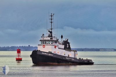
RACHELEBRUSCO
Tug
Current Trip
XX XXX>US^0TH6
| Time Travelled | 6 h, 51 mins |
|---|---|
| Remaining Time | --- |
| Distance Travelled | 26.29 nm |
| Remaining Distance | --- |
| AVG Speed | 4.9 Knots |
| MAX Speed | 7.5 Knots |
| AVG Wind | 17.2 knots |
| MAX Wind | 24 knots |
| MIN Temp | 9.3°C / 48.74°F |
| MAX Temp | 10.9°C / 51.62°F |
| Dybgang | 0 m |
| Position Modtaget | 16 h, 32 m siden |
Current Position
| Longitude | --- |
|---|---|
| Latitude | --- |
| Status | Under way using engine |
| Fart | 0.9 Knots |
| Kurs | 245° |
| Område | North Pacific Ocean |
| Station | T-AIS |
| Position Modtaget | 16 h, 32 m siden |
Info
Information
The current position of RACHELEBRUSCO is in North Pacific Ocean with coordinates 46.91692° / -124.13033° as reported on 2025-12-05 15:26 by AIS to our vessel tracker app. The vessel's current speed is 0.9 Knots
The vessel RACHELEBRUSCO (IMO: 7101827, MMSI: 367002210) is a Tug that was built in 1971 ( 54 år gamle ). It's sailing under the flag of [US] USA.
In this page you can find informations about the vessels current position, last detected port calls, and current voyage information. If the vessels is not in coverage by AIS you will find the latest position.
The current position of RACHELEBRUSCO is detected by our AIS receivers and we are not responsible for the reliability of the data. The last position was recorded while the vessel was in Coverage by the Ais receivers of our vessel tracking app.
Weather
| Temperature | 9.4°C / 48.92°F |
|---|---|
| Wind Speed | 14 knots |
| Direction | 264° W |
| Pressure | 1011.8 hPa |
| Humidity | 89 % |
| Cloud Coverage | 100 % |
Featured Company
Last Port Calls
| Port | Arrival | Departure | Time In Port |
|---|---|---|---|
| 2025-12-05 16:39 | 2025-12-05 17:07 | 27 m | |
| 2025-12-04 11:26 | 2025-12-04 12:07 | 40 m | |
| 2025-12-03 11:31 | 2025-12-03 12:15 | 44 m | |
| 2025-12-03 05:15 | 2025-12-03 05:47 | 31 m | |
| 2025-12-02 15:43 | 2025-12-02 16:15 | 32 m | |
| 2025-12-02 10:03 | 2025-12-02 10:43 | 40 m | |
| 2025-12-01 19:47 | 2025-12-01 20:23 | 36 m | |
| 2025-12-01 13:07 | 2025-12-01 13:31 | 24 m | |
| 2025-11-30 13:22 | 2025-11-30 16:00 | 2 h | |
| 2025-10-31 08:15 | 2025-11-30 11:35 |
Last Trips
| Origin | Departure | Destination | Arrival | Distance | |
|---|---|---|---|---|---|
| 2025-12-04 12:07 | 2025-12-05 16:39 | 112.26 nm | |||
| 2025-12-03 12:15 | 2025-12-04 11:26 | 107.54 nm | |||
| 2025-12-03 05:47 | 2025-12-03 11:31 | 25.67 nm | |||
| 2025-12-02 16:15 | 2025-12-03 05:15 | 57.74 nm | |||
| 2025-12-02 10:43 | 2025-12-02 15:43 | 25.64 nm | |||
| 2025-12-01 20:23 | 2025-12-02 10:03 | 57.32 nm | |||
| 2025-12-01 13:31 | 2025-12-01 19:47 | 28.76 nm | |||
| 2025-11-30 16:00 | 2025-12-01 13:07 | 97.63 nm | |||
| 2025-11-30 11:35 | 2025-11-30 13:22 | 21.91 nm | |||
| 2025-10-31 07:41 | 2025-10-31 08:15 | 5.07 nm |
Events
| Tid | Hændelsen | Detaljer | Position / Dest | Info |
|---|---|---|---|---|
| 2025-12-06 07:23 | START Sejllads | 0.67 nm, South West of HOQUIAM |
46.96798 / -123.88873
XX XXX>US^0TH6
|
Fart: 3.7 kn Kurs: 101° |
| 2025-12-06 07:15 | STOP Sejllads | 0.82 nm, South West of HOQUIAM |
46.96792 / -123.89415
XX XXX>US^0TH6
|
Fart: 0.3 kn Kurs: 273° |
| 2025-12-06 01:07 | Afsejlet fra sidste havn |
|
46.96819 / -123.87553
XX XXX>US^0TH6
|
Fart: 6.8 kn Kurs: 276° |
| 2025-12-06 00:51 | START Sejllads |
46.95989 / -123.83852
[US] ABERDEEN
|
Fart: 3.9 kn Kurs: 270° |
|
| 2025-12-06 00:39 | STOP Sejllads |
46.96102 / -123.83263
[US] ABERDEEN
|
Fart: 0.1 kn Kurs: 61° |
|
| 2025-12-06 00:39 | Skibe i havn |
|
46.96102 / -123.83263
[US] ABERDEEN
|
Fart: 4.8 kn Kurs: 89° |
| 2025-12-05 18:35 | START Sejllads | 0.84 nm, South West of HOQUIAM |
46.96790 / -123.89501
XX XXX>US^0TH6
|
Fart: 3.3 kn Kurs: 95° |
| 2025-12-05 18:23 | STOP Sejllads | 0.77 nm, South West of HOQUIAM |
46.96774 / -123.89215
XX XXX>US^0TH6
|
Fart: 0.3 kn Kurs: 275° |
| 2025-12-05 15:35 | Status er ændret | Default Under way using engine |
46.92275 / -124.12032
XX XXX>US^0TH6
|
Fart: 0.9 kn Kurs: 245° |
| 2025-12-05 15:26 | Udenfor Dækning |
46.91692 / -124.13033
North Pacific Ocean
|
Fart: 0.9 kn Kurs: 248° |