

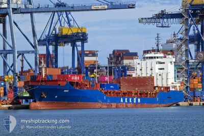
MAX
General Cargo
Current Trip
| Time Travelled | 5 days |
|---|---|
| Remaining Time | --- |
| Distance Travelled | 1208.10 nm |
| Remaining Distance | --- |
| AVG Speed | 13.1 Knots |
| MAX Speed | 15.4 Knots |
| AVG Wind | 11.5 knots |
| MAX Wind | 24.3 knots |
| MIN Temp | 6°C / 42.8°F |
| MAX Temp | 17.9°C / 64.22°F |
| Draught | 8.1 m |
| Position Received | 2 d ago |
Current Position
| Longitude | --- |
|---|---|
| Latitude | --- |
| Status | Under way using engine |
| Speed | 13 Knots |
| Course | 280.3° |
| Area | Mediterranean Sea - Eastern Basin |
| Station | T-AIS |
| Position Received | 2 d ago |
Information
The current position of MAX is in Mediterranean Sea - Eastern Basin with coordinates 36.71379° / 13.94743° as reported on 2025-03-25 14:17 by AIS to our vessel tracker app. The vessel's current speed is 13 Knots
The vessel MAX (IMO: 9351098, MMSI: 636020515) is a General Cargo that was built in 2006 ( 19 years old ). It's sailing under the flag of [LR] Liberia.
In this page you can find informations about the vessels current position, last detected port calls, and current voyage information. If the vessels is not in coverage by AIS you will find the latest position.
The current position of MAX is detected by our AIS receivers and we are not responsible for the reliability of the data. The last position was recorded while the vessel was in Coverage by the Ais receivers of our vessel tracking app.
The current draught of MAX as reported by AIS is 8.1 meters
Weather
| Temperature | 14.7°C / 58.46°F |
|---|---|
| Wind Speed | 14 knots |
| Direction | 298° WNW |
| Pressure | 1014.1 hPa |
| Humidity | 72.2 % |
| Cloud Coverage | 8 % |
Featured Company
Last Port Calls
| Port | Arrival | Departure | Time In Port |
|---|---|---|---|
| 2025-03-22 04:57 | 2025-03-22 17:46 | 12 h | |
| 2025-03-21 10:06 | 2025-03-21 23:31 | 13 h | |
| 2025-03-19 11:51 | 2025-03-21 06:08 | 1 d | |
| 2025-03-10 23:29 | 2025-03-15 03:59 | 4 d | |
| 2025-03-08 02:14 | 2025-03-10 04:12 | 2 d | |
| 2025-02-24 07:40 | 2025-02-25 07:50 | 1 d | |
| 2025-02-23 13:14 | 2025-02-23 23:14 | 9 h | |
| 2025-02-19 05:30 | |||
| 2025-02-06 17:52 | 2025-02-07 10:27 | 16 h | |
| 2025-02-05 07:40 | 2025-02-06 05:24 | 21 h |
Last Trips
| Origin | Departure | Destination | Arrival | Distance | |
|---|---|---|---|---|---|
| 2025-03-22 02:31 | 2025-03-22 07:57 | 63.10 nm | |||
| 2025-03-21 09:08 | 2025-03-21 13:06 | 43.65 nm | |||
| 2025-03-15 04:59 | 2025-03-19 14:51 | 1401.08 nm | |||
| 2025-03-10 05:12 | 2025-03-11 00:29 | 244.15 nm | |||
| 2025-02-25 10:50 | 2025-03-08 03:14 | 1193.38 nm | |||
| 2025-02-24 02:14 | 2025-02-24 10:40 | 46.77 nm | |||
| 2025-02-19 06:30 | 2025-02-23 16:14 | 1380.07 nm | |||
| 2025-02-06 08:24 | 2025-02-06 20:52 | 61.38 nm | |||
| 2025-02-02 19:28 | 2025-02-05 10:40 | 707.28 nm | |||
| 2025-01-22 19:57 | 2025-01-29 22:48 | 550.60 nm |
Events
| Time | Event | Details | Position / Dest | Info |
|---|---|---|---|---|
| 2025-03-26 16:32 | STOP Moving | 2.06 nm, North East of ANNABA |
36.93639 / 7.79568
DZAAE
|
Speed: 0.1 kn Course: 299° |
| 2025-03-25 14:20 | Status Changed | Default Under way using engine |
36.71621 / 13.93104
DZAAE
|
Speed: 13 kn Course: 280.3° |
| 2025-03-25 14:17 | Status Changed | Under way using engine Default |
36.71379 / 13.94743
DZAAE
|
Speed: 13 kn Course: 283° |
| 2025-03-25 14:17 | OUT of Coverage |
36.71379 / 13.94743
Mediterranean Sea - Eastern Basin
DZAAE
|
Speed: 13 kn Course: 280.3° |
|
| 2025-03-25 13:59 | Status Changed | Default Under way using engine |
36.70125 / 14.02421
DZAAE
|
Speed: 13 kn Course: 281.2° |
| 2025-03-25 11:39 | Status Changed | Under way using engine Default |
36.59523 / 14.65413
DZAAE
|
Speed: 13.3 kn Course: 288° |
| 2025-03-25 11:28 | Status Changed | Default Under way using engine |
36.58213 / 14.70184
DZAAE
|
Speed: 13 kn Course: 292.3° |
| 2025-03-25 11:18 | Status Changed | Under way using engine Default |
36.57041 / 14.74510
DZAAE
|
Speed: 13.1 kn Course: 281° |
| 2025-03-25 11:00 | IN Coverage |
36.57041 / 14.74510
Mediterranean Sea - Eastern Basin
DZAAE
|
Speed: 13.4 kn Course: 287.7° |
|
| 2025-03-25 09:54 | OUT of Coverage |
36.55810 / 15.12045
Mediterranean Sea - Eastern Basin
DZAAE
|
Speed: 13.6 kn Course: 268.7° |