
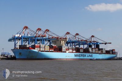
MARY MAERSK
Container Ship
Current Trip
| Time Travelled | 1 day |
|---|---|
| Remaining Time | 7 h, 26 mins |
| Distance Travelled | 408.25 nm |
| Remaining Distance | 102.50 nm |
| AVG Speed | 12.2 Knots |
| MAX Speed | 14.3 Knots |
| AVG Wind | 21 knots |
| MAX Wind | 31 knots |
| MIN Temp | -3.4°C / 25.88°F |
| MAX Temp | 4.9°C / 40.82°F |
| Draught | 12 m |
| Position Received | 1 m ago |
Current Position
| Longitude | --- |
|---|---|
| Latitude | --- |
| Status | Under way using engine |
| Speed | 13.2 Knots |
| Course | 193.3° |
| Area | North Sea |
| Station | T-AIS |
| Position Received | 1 m ago |
Info
Information
The current position of MARY MAERSK is in North Sea with coordinates 53.38338° / 4.50883° as reported on 2026-01-04 02:24 by AIS to our vessel tracker app. The vessel's current speed is 13.2 Knots and is heading at the port of MAASVLAKTE - ROTTERDAM. The estimated time of arrival as calculated by MyShipTracking vessel tracking app is 2026-01-04 10:52 LT
The vessel MARY MAERSK (IMO: 9619921, MMSI: 219018692) is a Container Ship that was built in 2013 ( 13 years old ). It's sailing under the flag of [DK] Denmark.
In this page you can find informations about the vessels current position, last detected port calls, and current voyage information. If the vessels is not in coverage by AIS you will find the latest position.
The current position of MARY MAERSK is detected by our AIS receivers and we are not responsible for the reliability of the data. The last position was recorded while the vessel was in Coverage by the Ais receivers of our vessel tracking app.
The current draught of MARY MAERSK as reported by AIS is 12 meters
Weather
| Temperature | 4.7°C / 40.46°F |
|---|---|
| Wind Speed | 27 knots |
| Direction | 313° NW |
| Pressure | 1002.9 hPa |
| Humidity | 62.8 % |
| Cloud Coverage | 100 % |
Featured Company
Last Port Calls
| Port | Arrival | Departure | Time In Port |
|---|---|---|---|
| 2026-01-01 20:31 | 2026-01-02 17:54 | 21 h | |
| 2025-12-29 09:00 | 2025-12-30 17:42 | 1 d | |
| 2025-12-26 00:40 | 2025-12-28 02:46 | 2 d | |
| 2025-12-21 13:07 | 2025-12-22 17:37 | 1 d | |
| 2025-11-21 00:56 | 2025-11-23 06:21 | 2 d | |
| 2025-11-15 14:24 | 2025-11-16 16:44 | 1 d | |
| 2025-11-08 16:24 | 2025-11-11 07:25 | 2 d |
Most Visited Ports (Last year)
| Port | Arrivals | |
|---|---|---|
| 6 | ||
| 5 | ||
| 4 | ||
| 3 | ||
| 3 | ||
| 3 |
Last Trips
| Origin | Departure | Destination | Arrival | Distance | |
|---|---|---|---|---|---|
| 2025-12-30 17:42 | 2026-01-01 20:31 | 143.94 nm | |||
| 2025-12-28 02:46 | 2025-12-29 09:00 | 505.93 nm | |||
| 2025-12-22 17:37 | 2025-12-26 00:40 | 436.26 nm | |||
| 2025-11-23 06:21 | 2025-12-21 13:07 | 12074.68 nm | |||
| 2025-11-16 16:44 | 2025-11-21 00:56 | 1496.14 nm | |||
| 2025-11-11 07:25 | 2025-11-15 14:24 | 1212.89 nm | |||
| 2025-10-30 03:18 | 2025-11-08 16:24 | 2622.82 nm |
Events
| Time | Event | Details | Position / Dest | Info |
|---|---|---|---|---|
| 2026-01-04 00:12 | Status Changed | Under way using engine Default |
53.83853 / 4.80068
SEGOT>NLROT
|
Speed: 13.1 kn Course: 203° |
| 2026-01-04 00:09 | Status Changed | Default Under way using engine |
53.85074 / 4.80970
SEGOT>NLROT
|
Speed: 13.1 kn Course: 202.3° |
| 2026-01-04 00:04 | Detected in Sea | Dutch part of the North Sea |
53.86632 / 4.82140
North Sea
SEGOT>NLROT
|
Speed: 13.1 kn Course: 202.3° |
| 2026-01-04 00:04 | Status Changed | Under way using engine Default |
53.86632 / 4.82140
SEGOT>NLROT
|
Speed: 13.1 kn Course: 202° |
| 2026-01-04 00:04 | IN Coverage |
53.86632 / 4.82140
North Sea
SEGOT>NLROT
|
Speed: 13.1 kn Course: 202.3° |
|
| 2026-01-03 12:59 | Status Changed | Default Under way using engine |
55.82796 / 6.76640
SEGOT>NLROT
|
Speed: 13.1 kn Course: 205.5° |
| 2026-01-03 12:50 | OUT of Coverage |
55.85720 / 6.79202
North Sea
SEGOT>NLROT
|
Speed: 13.1 kn Course: 205.5° |
|
| 2026-01-03 12:14 | Status Changed | Under way using engine Default |
55.97253 / 6.89110
SEGOT>NLROT
|
Speed: 12.6 kn Course: 207° |
| 2026-01-03 12:12 | Status Changed | Default Under way using engine |
55.97743 / 6.89527
SEGOT>NLROT
|
Speed: 12.6 kn Course: 206.4° |
| 2026-01-03 11:11 | Status Changed | Under way using engine Default |
56.16973 / 7.05650
SEGOT>NLROT
|
Speed: 12.6 kn Course: 204° |