
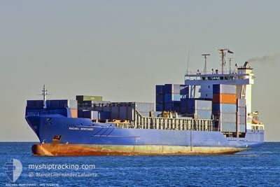
KATHERINE BORCHARD
Container Ship
Current Trip
| Trip Time | 3 days |
|---|---|
| Trip Distance | 765.38 nm |
| AVG Speed | 13 Knots |
| MAX Speed | 19.5 Knots |
| Draught | 6.5 m |
| AVG Wind | 17.8 knots |
| MAX Wind | 38 knots |
| MIN Temp | 3.2°C / 37.76°F |
| MAX Temp | 11.3°C / 52.34°F |
| Position Received | 1 m ago |
Current Position
| Longitude | --- |
|---|---|
| Latitude | --- |
| Status | Moored |
| Speed | |
| Course | 91° |
| Area | North Sea |
| Station | T-AIS |
| Position Received | 1 m ago |
Info
Information
The current position of KATHERINE BORCHARD is in North Sea with coordinates 51.27910° / 4.35234° as reported on 2025-01-03 21:09 by AIS to our vessel tracker app. The vessel's current speed is 0 Knots and is currently inside the port of ANTWERP.
The vessel KATHERINE BORCHARD (IMO: 9246530, MMSI: 304623000) is a Container Ship that was built in 2004 ( 21 years old ). It's sailing under the flag of [AG] Antigua Barbuda.
In this page you can find informations about the vessels current position, last detected port calls, and current voyage information. If the vessels is not in coverage by AIS you will find the latest position.
The current position of KATHERINE BORCHARD is detected by our AIS receivers and we are not responsible for the reliability of the data. The last position was recorded while the vessel was in Coverage by the Ais receivers of our vessel tracking app.
The current draught of KATHERINE BORCHARD as reported by AIS is 6.5 meters
Weather
| Temperature | 4°C / 39.2°F |
|---|---|
| Wind Speed | 5 knots |
| Direction | 273° W |
| Pressure | 1022.6 hPa |
| Humidity | 75 % |
| Cloud Coverage | 100 % |
Featured Company
Last Port Calls
| Port | Arrival | Departure | Time In Port |
|---|---|---|---|
| 2025-01-03 16:17 | |||
| 2024-12-30 10:52 | 2024-12-30 23:57 | 13 h | |
| 2024-12-29 06:38 | 2024-12-29 19:14 | 12 h | |
| 2024-12-25 13:46 | 2024-12-26 11:45 | 21 h | |
| 2024-12-22 05:22 | 2024-12-22 14:26 | 9 h | |
| 2024-12-18 05:11 | 2024-12-18 21:07 | 15 h | |
| 2024-12-14 18:26 | 2024-12-15 11:13 | 16 h | |
| 2024-12-12 13:13 | 2024-12-13 00:25 | 11 h | |
| 2024-12-10 18:14 | 2024-12-11 08:04 | 13 h | |
| 2024-12-10 06:43 | 2024-12-10 11:45 | 5 h |
Last Trips
| Origin | Departure | Destination | Arrival | Distance | |
|---|---|---|---|---|---|
| 2024-12-30 23:57 | 2025-01-03 17:17 | 765.38 nm | |||
| 2024-12-29 19:14 | 2024-12-30 10:52 | 121.54 nm | |||
| 2024-12-26 11:45 | 2024-12-29 06:38 | 847.68 nm | |||
| 2024-12-22 15:26 | 2024-12-25 13:46 | 895.77 nm | |||
| 2024-12-18 22:07 | 2024-12-22 06:22 | 832.81 nm | |||
| 2024-12-15 13:13 | 2024-12-18 06:11 | 989.99 nm | |||
| 2024-12-13 03:25 | 2024-12-14 20:26 | 476.63 nm | |||
| 2024-12-11 10:04 | 2024-12-12 16:13 | 334.90 nm | |||
| 2024-12-10 13:45 | 2024-12-10 20:14 | 81.94 nm | |||
| 2024-12-09 20:53 | 2024-12-10 08:43 | 162.60 nm |
Events
| Time | Event | Details | Position / Dest | Info |
|---|---|---|---|---|
| 2025-01-03 19:42 | STOP Moving |
51.27917 / 4.35231
[BE] ANTWERP
|
Speed: Course: 90° |
|
| 2025-01-03 19:27 | Status Changed | Moored Under way using engine |
51.27929 / 4.35061
[BE] ANTWERP
|
Speed: 0.8 kn Course: 91° |
| 2025-01-03 18:41 | START Moving |
51.34391 / 4.28979
[BE] ANTWERP
|
Speed: 4 kn Course: 104° |
|
| 2025-01-03 17:00 | STOP Moving |
51.34421 / 4.28677
[BE] ANTWERP
|
Speed: 0.3 kn Course: 97° |
|
| 2025-01-03 16:17 | PORT ARRIVAL |
|
51.36606 / 4.22051
[BE] ANTWERP
|
Speed: 10.4 kn Course: 154.1° |
| 2025-01-03 13:19 | Change Sea Area | Dutch part of the North Sea Belgian part of the North Sea |
51.40011 / 3.34636
North Sea
|
Speed: 19.1 kn Course: 91.4° |
| 2025-01-03 10:51 | START Moving | 12.22 nm, North West of NIEUWPOORT |
51.31694 / 2.60873
BE ANR
|
Speed: 3.6 kn Course: 0° |
| 2025-01-03 10:50 | Status Changed | Under way using engine At anchor |
51.31586 / 2.60848
BE ANR
|
Speed: 0.3 kn Course: 8° |
| 2025-01-03 08:14 | STOP Moving | 12.13 nm, North West of NIEUWPOORT |
51.31508 / 2.60809
BE ANR
|
Speed: 0.1 kn Course: 2° |
| 2025-01-03 08:06 | Status Changed | At anchor Under way using engine |
51.31623 / 2.60782
BE ANR
|
Speed: 1.5 kn Course: 26° |