

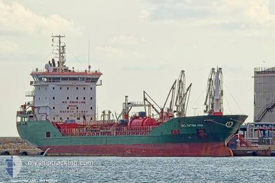
HACI FATMA ANA
Oil/Chemical Tanker

Current Trip
| Time Travelled | 10 h, 32 mins |
|---|---|
| Remaining Time | 2 h, 11 mins |
| Distance Travelled | 90.56 nm |
| Remaining Distance | 22.69 nm |
| AVG Speed | 8.9 Knots |
| MAX Speed | 11.3 Knots |
| AVG Wind | 11.7 knots |
| MAX Wind | 21.7 knots |
| MIN Temp | 10.6°C / 51.08°F |
| MAX Temp | 12.7°C / 54.86°F |
| Draught | 4.8 m |
| Position Received | Now |
Current Position
| Longitude | --- |
|---|---|
| Latitude | --- |
| Status | Under way using engine |
| Speed | 6.7 Knots |
| Course | 112.1° |
| Area | North Atlantic Ocean |
| Station | T-AIS |
| Position Received | Now |
Information
The current position of HACI FATMA ANA is in North Atlantic Ocean with coordinates 43.54991° / -8.74494° as reported on 2025-03-10 06:10 by AIS to our vessel tracker app. The vessel's current speed is 6.7 Knots and is heading at the port of CORUNA. The estimated time of arrival as calculated by MyShipTracking vessel tracking app is 2025-03-10 09:22 LT
The vessel HACI FATMA ANA (IMO: 9458195, MMSI: 215552000) is a Oil/Chemical Tanker that was built in 2011 ( 14 years old ). It's sailing under the flag of [MT] Malta.
In this page you can find informations about the vessels current position, last detected port calls, and current voyage information. If the vessels is not in coverage by AIS you will find the latest position.
The current position of HACI FATMA ANA is detected by our AIS receivers and we are not responsible for the reliability of the data. The last position was recorded while the vessel was in Coverage by the Ais receivers of our vessel tracking app.
The current draught of HACI FATMA ANA as reported by AIS is 4.8 meters
Weather
| Temperature | 11.3°C / 52.34°F |
|---|---|
| Wind Speed | 19 knots |
| Direction | 142° SE |
| Pressure | 994.6 hPa |
| Humidity | 66.5 % |
| Cloud Coverage | 80 % |


Featured Company
Last Port Calls
| Port | Arrival | Departure | Time In Port |
|---|---|---|---|
| 2025-03-09 09:07 | 2025-03-09 20:39 | 11 h | |
| 2025-03-06 08:31 | 2025-03-06 21:25 | 12 h | |
| 2025-03-02 10:06 | 2025-03-03 17:00 | 1 d | |
| 2025-02-28 05:35 | 2025-03-01 17:13 | 1 d | |
| 2025-02-13 20:17 | 2025-02-16 20:29 | 3 d | |
| 2025-01-30 13:13 | 2025-02-02 08:55 | 2 d | |
| 2025-01-16 20:17 | 2025-01-21 13:45 | 4 d | |
| 2025-01-11 23:29 | 2025-01-14 03:45 | 2 d | |
| 2025-01-06 21:48 | 2025-01-07 12:30 | 14 h | |
| 2025-01-04 11:59 | 2025-01-05 17:11 | 1 d |
Last Trips
| Origin | Departure | Destination | Arrival | Distance | |
|---|---|---|---|---|---|
| 2025-03-06 21:25 | 2025-03-09 09:07 | 668.88 nm | |||
| 2025-03-03 17:00 | 2025-03-06 08:31 | 649.16 nm | |||
| 2025-03-01 17:13 | 2025-03-02 10:06 | 67.35 nm | |||
| 2025-02-16 20:29 | 2025-02-28 05:35 | 752.73 nm | |||
| 2025-02-02 08:55 | 2025-02-13 20:17 | 931.34 nm | |||
| 2025-01-21 13:45 | 2025-01-30 13:13 | 749.55 nm | |||
| 2025-01-14 03:45 | 2025-01-16 20:17 | 735.46 nm | |||
| 2025-01-07 12:30 | 2025-01-11 23:29 | 1128.80 nm | |||
| 2025-01-05 17:11 | 2025-01-06 21:48 | 39.01 nm | |||
| 2024-12-25 20:23 | 2025-01-04 11:59 | 1578.02 nm |
Events
| Time | Event | Details | Position / Dest | Info |
|---|---|---|---|---|
| 2025-03-10 04:41 | Status Changed | Under way using engine Default |
43.66428 / -9.02873
ESFRO>ESLCG
|
Speed: 9.6 kn Course: 120° |
| 2025-03-10 04:31 | Status Changed | Default Under way using engine |
43.67691 / -9.05835
ESFRO>ESLCG
|
Speed: 9.6 kn Course: 124.5° |
| 2025-03-10 04:31 | Status Changed | Under way using engine Default |
43.67780 / -9.06055
ESFRO>ESLCG
|
Speed: 9.5 kn Course: 119° |
| 2025-03-10 04:31 | IN Coverage |
43.67780 / -9.06055
North Atlantic Ocean
ESFRO>ESLCG
|
Speed: 9.6 kn Course: 124.5° |
|
| 2025-03-09 23:34 | Status Changed | Default Under way using engine |
43.79832 / -8.78071
ESFRO>ESLCG
|
Speed: 8.5 kn Course: 323.8° |
| 2025-03-09 23:19 | OUT of Coverage |
43.76857 / -8.75460
North Atlantic Ocean
ESFRO>ESLCG
|
Speed: 8.5 kn Course: 323.8° |
|
| 2025-03-09 23:09 | Status Changed | Under way using engine Default |
43.74692 / -8.73615
ESFRO>ESLCG
|
Speed: 8.6 kn Course: 329° |
| 2025-03-09 22:51 | Status Changed | Default Under way using engine |
43.71134 / -8.70969
ESFRO>ESLCG
|
Speed: 8.6 kn Course: 330.6° |
| 2025-03-09 22:46 | Status Changed | Under way using engine Default |
43.70038 / -8.70147
ESFRO>ESLCG
|
Speed: 8.6 kn Course: 349° |
| 2025-03-09 22:21 | Status Changed | Default Under way using engine |
43.63970 / -8.68187
ESFRO>ESLCG
|
Speed: 7.7 kn Course: 330.7° |