
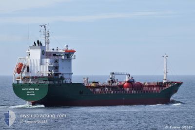
HACI FATMA ANA
Oil/Chemical Tanker
Current Trip
| Time Travelled | 5 days |
|---|---|
| Remaining Time | 2 days |
| Distance Travelled | 1424.55 nm |
| Remaining Distance | 710.81 nm |
| AVG Speed | 10.8 Knots |
| MAX Speed | 13.8 Knots |
| AVG Wind | 12 knots |
| MAX Wind | 22.8 knots |
| MIN Temp | 9.4°C / 48.92°F |
| MAX Temp | 18.2°C / 64.76°F |
| Dybgang | 6.1 m |
| Position Modtaget | 1 m siden |
Current Position
| Longitude | -5.60587° |
|---|---|
| Latitude | 35.91265° |
| Status | Under way using engine |
| Fart | 11.6 Knots |
| Kurs | 87.7° |
| Område | Strait of Gibraltar |
| Station | T-AIS |
| Position Modtaget | 1 m siden |
Info
Information
The current position of HACI FATMA ANA is in Strait of Gibraltar with coordinates 35.91265° / -5.60587° as reported on 2024-05-04 21:19 by AIS to our vessel tracker app. The vessel's current speed is 11.6 Knots and is heading at the port of FOS. The estimated time of arrival as calculated by MyShipTracking vessel tracking app is 2024-05-07 12:36 LT
The vessel HACI FATMA ANA (IMO: 9458195, MMSI: 215552000) is a Oil/Chemical Tanker that was built in 2011 ( 13 år gamle ). It's sailing under the flag of [MT] Malta.
In this page you can find informations about the vessels current position, last detected port calls, and current voyage information. If the vessels is not in coverage by AIS you will find the latest position.
The current position of HACI FATMA ANA is detected by our AIS receivers and we are not responsible for the reliability of the data. The last position was recorded while the vessel was in Coverage by the Ais receivers of our vessel tracking app.
The current draught of HACI FATMA ANA as reported by AIS is 6.1 meters
Weather
| Temperature | 15.5°C / 59.9°F |
|---|---|
| Wind Speed | 8 knots |
| Direction | 259° W |
| Pressure | 1018.5 hPa |
| Humidity | 77.2 % |
| Cloud Coverage | 43 % |
Featured Company
Last Port Calls
| Port | Arrival | Departure | Time In Port |
|---|---|---|---|
| 2024-04-27 16:26 | 2024-04-29 10:47 | 1 d | |
| 2024-04-26 18:26 | 2024-04-27 15:13 | 20 h | |
| 2024-04-25 16:44 | 2024-04-26 17:50 | 1 d | |
| 2024-04-17 11:18 | 2024-04-18 09:39 | 22 h | |
| 2024-04-12 21:10 | 2024-04-13 21:58 | 1 d | |
| 2024-04-11 17:17 | 2024-04-12 03:44 | 10 h | |
| 2024-04-10 10:43 | 2024-04-11 04:25 | 17 h | |
| 2024-04-02 11:56 | 2024-04-06 01:52 | 3 d | |
| 2024-03-28 05:41 | 2024-03-30 06:22 | 2 d | |
| 2024-03-24 01:33 | 2024-03-24 22:37 | 21 h |
Last Trips
| Origin | Departure | Destination | Arrival | Distance | |
|---|---|---|---|---|---|
| 2024-04-27 17:13 | 2024-04-27 18:26 | 12.13 nm | |||
| 2024-04-26 19:50 | 2024-04-26 20:26 | 2.51 nm | |||
| 2024-04-18 11:39 | 2024-04-25 18:44 | 1916.06 nm | |||
| 2024-04-13 23:58 | 2024-04-17 13:18 | 766.81 nm | |||
| 2024-04-12 05:44 | 2024-04-12 23:10 | 188.71 nm | |||
| 2024-04-11 06:25 | 2024-04-11 19:17 | 70.04 nm | |||
| 2024-04-06 03:52 | 2024-04-10 12:43 | 1134.58 nm | |||
| 2024-03-30 08:22 | 2024-04-02 13:56 | 206.10 nm | |||
| 2024-03-24 23:37 | 2024-03-28 07:41 | 814.52 nm | |||
| 2024-03-21 03:50 | 2024-03-24 02:33 | 809.76 nm |
Events
| Tid | Hændelsen | Detaljer | Position / Dest | Info |
|---|---|---|---|---|
| 2024-05-04 20:33 | Status er ændret | Under way using engine Default |
35.90621 / -5.77772
NLRTM>FRFOS
|
Fart: 11 kn Kurs: 79° |
| 2024-05-04 20:17 | Status er ændret | Default Under way using engine |
35.89619 / -5.83795
NLRTM>FRFOS
|
Fart: 11 kn Kurs: 87.1° |
| 2024-05-04 20:14 | Ændre havområde | Moroccan part of the Strait of Gibraltar Moroccan part of the North Atlantic Ocean |
35.89519 / -5.84971
Strait of Gibraltar
|
Fart: 11 kn Kurs: 87.1° |
| 2024-05-04 20:14 | Status er ændret | Under way using engine Default |
35.89519 / -5.84971
NLRTM>FRFOS
|
Fart: 11 kn Kurs: 87° |
| 2024-05-04 19:34 | Status er ændret | Default Under way using engine |
35.89498 / -5.99699
NLRTM>FRFOS
|
Fart: 11.2 kn Kurs: 87.8° |
| 2024-05-04 18:01 | Ændre havområde | Moroccan part of the North Atlantic Ocean Spanish part of the North Atlantic Ocean |
35.91658 / -6.36483
North Atlantic Ocean
|
Fart: 12.3 kn Kurs: 103.2° |
| 2024-05-04 16:52 | Status er ændret | Under way using engine Default |
35.97540 / -6.64621
NLRTM>FRFOS
|
Fart: 12.1 kn Kurs: 105° |
| 2024-05-04 16:50 | Status er ændret | Default Under way using engine |
35.97691 / -6.65356
NLRTM>FRFOS
|
Fart: 12 kn Kurs: 104.5° |
| 2024-05-04 16:41 | Status er ændret | Under way using engine Default |
35.98457 / -6.69079
NLRTM>FRFOS
|
Fart: 12 kn Kurs: 105° |
| 2024-05-04 16:39 | Status er ændret | Default Under way using engine |
35.98652 / -6.70003
NLRTM>FRFOS
|
Fart: 11.9 kn Kurs: 103° |