

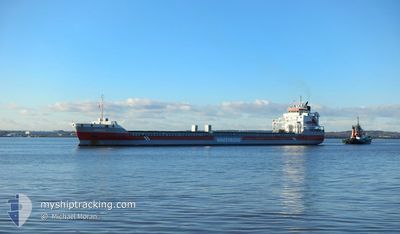
EEBORG
General Cargo

Current Trip
| Trip Time | 1 day |
|---|---|
| Trip Distance | 329.30 nm |
| AVG Speed | 10.5 Knots |
| MAX Speed | 13.3 Knots |
| Draught | 6 m |
| AVG Wind | 8.1 knots |
| MAX Wind | 14 knots |
| MIN Temp | -17°C / 1.4°F |
| MAX Temp | 2.1°C / 35.78°F |
| Position Received | 3 d ago |
Current Position
| Longitude | --- |
|---|---|
| Latitude | --- |
| Status | Under way using engine |
| Speed | 11.4 Knots |
| Course | 333.3° |
| Area | Gulf of Bothnia |
| Station | T-AIS |
| Position Received | 3 d ago |
Information
The current position of EEBORG is in Gulf of Bothnia with coordinates 61.43381° / 20.95913° as reported on 2025-03-19 21:47 by AIS to our vessel tracker app. The vessel's current speed is 11.4 Knots and is currently inside the port of AJOS.
The vessel EEBORG (IMO: 9568328, MMSI: 246846000) is a General Cargo that was built in 2012 ( 13 years old ). It's sailing under the flag of [NL] Netherlands.
In this page you can find informations about the vessels current position, last detected port calls, and current voyage information. If the vessels is not in coverage by AIS you will find the latest position.
The current position of EEBORG is detected by our AIS receivers and we are not responsible for the reliability of the data. The last position was recorded while the vessel was in Coverage by the Ais receivers of our vessel tracking app.
The current draught of EEBORG as reported by AIS is 6 meters
Weather
| Temperature | -1.1°C / 30.02°F |
|---|---|
| Wind Speed | 15 knots |
| Direction | 209° SSW |
| Pressure | 1022.2 hPa |
| Humidity | 89 % |
| Cloud Coverage | 24 % |


Featured Company
Last Port Calls
| Port | Arrival | Departure | Time In Port |
|---|---|---|---|
| 2025-03-21 06:01 | |||
| 2025-03-14 14:36 | 2025-03-19 21:11 | 5 d | |
| 2025-03-12 14:16 | 2025-03-14 11:37 | 1 d | |
| 2025-03-09 10:46 | 2025-03-12 13:37 | 3 d | |
| 2025-03-06 01:34 | 2025-03-06 01:39 | 4 m | |
| 2025-03-01 03:32 | 2025-03-04 05:47 | 3 d | |
| 2025-02-21 15:27 | 2025-02-27 12:48 | 5 d | |
| 2025-02-14 00:08 | 2025-02-14 01:02 | 54 m | |
| 2025-02-10 18:06 | 2025-02-13 00:46 | 2 d | |
| 2025-02-06 16:54 | 2025-02-08 22:48 | 2 d |
Last Trips
| Origin | Departure | Destination | Arrival | Distance | |
|---|---|---|---|---|---|
| 2025-03-19 21:11 | 2025-03-21 06:01 | 329.30 nm | |||
| 2025-03-14 11:37 | 2025-03-14 14:36 | 36.12 nm | |||
| 2025-03-12 13:37 | 2025-03-12 14:16 | 0.19 nm | |||
| 2025-03-06 01:39 | 2025-03-09 10:46 | 677.33 nm | |||
| 2025-03-04 05:47 | 2025-03-06 01:34 | 414.62 nm | |||
| 2025-02-27 12:48 | 2025-03-01 03:32 | 34.40 nm | |||
| 2025-02-14 01:02 | 2025-02-21 15:27 | 397.59 nm | |||
| 2025-02-13 00:46 | 2025-02-14 00:08 | 225.34 nm | |||
| 2025-02-08 22:48 | 2025-02-10 18:06 | 171.89 nm | |||
| 2025-02-03 11:37 | 2025-02-06 16:54 | 770.51 nm |
Events
| Time | Event | Details | Position / Dest | Info |
|---|---|---|---|---|
| 2025-03-21 04:21 | STOP Moving |
65.66129 / 24.51839
[FI] AJOS
|
Speed: 0.1 kn Course: 48° |
|
| 2025-03-21 04:01 | PORT ARRIVAL |
|
65.65653 / 24.50919
[FI] AJOS
|
Speed: 3.3 kn Course: 15° |
| 2025-03-21 03:18 | START Moving | 6.82 nm, South of AJOS |
65.55145 / 24.43693
FIKEM
|
Speed: 7.5 kn Course: 31° |
| 2025-03-20 23:58 | STOP Moving | 7.32 nm, South of AJOS |
65.54398 / 24.42746
FIKEM
|
Speed: Course: 42° |
| 2025-03-20 19:58 | START Moving |
65.35696 / 23.12740
FIKEM
|
Speed: 9.2 kn Course: 63° |
|
| 2025-03-20 19:42 | STOP Moving |
65.35482 / 23.11567
FIKEM
|
Speed: 0.2 kn Course: 73° |
|
| 2025-03-19 21:54 | Status Changed | Default Under way using engine |
61.45272 / 20.93931
FIKEM
|
Speed: 11.4 kn Course: 333.3° |
| 2025-03-19 21:47 | OUT of Coverage |
61.43381 / 20.95913
Gulf of Bothnia
FIKEM
|
Speed: 11.4 kn Course: 333.3° |
|
| 2025-03-19 19:11 | PORT DEPARTURE |
|
61.12965 / 21.42128
FIKEM
|
Speed: 4.7 kn Course: 324° |
| 2025-03-19 19:09 | START Moving |
61.12727 / 21.42400
[FI] RAUMA
|
Speed: 3.6 kn Course: 331° |