

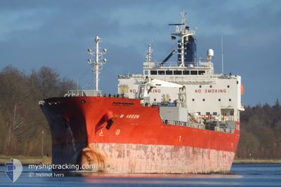
CHEM ARGON
Tanker

Current Trip
| Trip Time | 6 days |
|---|---|
| Trip Distance | 518.41 nm |
| AVG Speed | 12 Knots |
| MAX Speed | 14.4 Knots |
| Draught | 7.9 m |
| AVG Wind | 4.9 knots |
| MAX Wind | 15 knots |
| MIN Temp | 8.7°C / 47.66°F |
| MAX Temp | 24.6°C / 76.28°F |
| Position Received | 2 h, 5 m ago |
Current Position
| Longitude | --- |
|---|---|
| Latitude | --- |
| Status | Moored |
| Speed | |
| Course | 318° |
| Area | Gulf of Mexico |
| Station | T-AIS |
| Position Received | 2 h, 5 m ago |
Information
The current position of CHEM ARGON is in Gulf of Mexico with coordinates 29.74328° / -95.09826° as reported on 2025-03-27 10:32 by AIS to our vessel tracker app. The vessel's current speed is 0 Knots and is currently inside the port of HOUSTON.
The vessel CHEM ARGON (IMO: 9716004, MMSI: 636019198) is a Tanker It's sailing under the flag of [LR] Liberia.
In this page you can find informations about the vessels current position, last detected port calls, and current voyage information. If the vessels is not in coverage by AIS you will find the latest position.
The current position of CHEM ARGON is detected by our AIS receivers and we are not responsible for the reliability of the data. The last position was recorded while the vessel was in Coverage by the Ais receivers of our vessel tracking app.
The current draught of CHEM ARGON as reported by AIS is 7.9 meters
Weather
| Temperature | 18°C / 64.4°F |
|---|---|
| Wind Speed | 4 knots |
| Direction | 102° ESE |
| Pressure | 1019 hPa |
| Humidity | 86.7 % |
| Cloud Coverage | 100 % |


Featured Company
Last Port Calls
| Port | Arrival | Departure | Time In Port |
|---|---|---|---|
| 2025-03-27 03:21 | |||
| 2025-03-19 05:40 | 2025-03-20 08:08 | 1 d | |
| 2025-03-10 04:19 | 2025-03-11 12:58 | 1 d | |
| 2025-02-18 20:38 | 2025-02-20 05:39 | 1 d | |
| 2025-02-12 01:46 | 2025-02-16 20:40 | 4 d | |
| 2025-02-10 19:21 | 2025-02-12 00:53 | 1 d | |
| 2025-02-08 10:11 | 2025-02-10 18:57 | 2 d | |
| 2025-02-02 17:50 | 2025-02-05 02:06 | 2 d | |
| 2025-02-01 07:33 | 2025-02-01 07:38 | 4 m | |
| 2025-01-29 14:32 | 2025-01-30 16:18 | 1 d |
Most Visited Ports (Last year)
| Port | Arrivals | |
|---|---|---|
| 5 | ||
| 3 | ||
| 3 | ||
| 3 | ||
| 3 | ||
| 2 |
Last Trips
| Origin | Departure | Destination | Arrival | Distance | |
|---|---|---|---|---|---|
| 2025-03-20 08:08 | 2025-03-27 03:21 | 518.41 nm | |||
| 2025-03-11 12:58 | 2025-03-19 05:40 | 1934.42 nm | |||
| 2025-02-20 05:39 | 2025-03-10 04:19 | 4047.28 nm | |||
| 2025-02-16 20:40 | 2025-02-18 20:38 | 364.11 nm | |||
| 2025-02-12 00:53 | 2025-02-12 01:46 | 3.05 nm | |||
| 2025-02-10 18:57 | 2025-02-10 19:21 | 1.69 nm | |||
| 2025-02-05 02:06 | 2025-02-08 10:11 | 827.24 nm | |||
| 2025-02-01 07:38 | 2025-02-02 17:50 | 414.27 nm | |||
| 2025-01-30 16:18 | 2025-02-01 07:33 | 366.09 nm | |||
| 2025-01-28 22:18 | 2025-01-29 14:32 | 96.21 nm |
Events
| Time | Event | Details | Position / Dest | Info |
|---|---|---|---|---|
| 2025-03-27 10:40 | Status Changed | Default Moored |
29.74333 / -95.09825
[US] HOUSTON
|
Speed: Course: 318° |
| 2025-03-27 10:32 | OUT of Coverage |
29.74328 / -95.09826
Gulf of Mexico
[US] HOUSTON
|
Speed: Course: 149.9° |
|
| 2025-03-27 10:31 | Status Changed | Moored Under way using engine |
29.74336 / -95.09823
[US] HOUSTON
|
Speed: Course: 318° |
| 2025-03-27 10:23 | STOP Moving |
29.74350 / -95.09828
[US] HOUSTON
|
Speed: 0.3 kn Course: 321° |
|
| 2025-03-27 08:21 | PORT ARRIVAL |
|
29.59242 / -94.94105
[US] HOUSTON
|
Speed: 10.2 kn Course: 326.2° |
| 2025-03-27 06:37 | Status Changed | Under way using engine Default |
29.34591 / -94.72207
US HOU
|
Speed: 11.5 kn Course: 267° |
| 2025-03-27 06:16 | Status Changed | Default Under way using engine |
29.32161 / -94.65207
US HOU
|
Speed: 11.3 kn Course: 301.9° |
| 2025-03-27 06:08 | Status Changed | Under way using engine Default |
29.30958 / -94.62936
US HOU
|
Speed: 11.1 kn Course: 293° |
| 2025-03-27 06:04 | Status Changed | Default Under way using engine |
29.30216 / -94.61425
US HOU
|
Speed: 11 kn Course: 293.3° |
| 2025-03-27 06:03 | Status Changed | Under way using engine Default |
29.30152 / -94.61257
US HOU
|
Speed: 10.8 kn Course: 294° |