
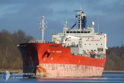
CHEM ARGON
Tanker
Current Trip
| Time Travelled | 1 day |
|---|---|
| Remaining Time | --- |
| Distance Travelled | 289.08 nm |
| Remaining Distance | --- |
| AVG Speed | 11 Noeuds |
| MAX Speed | 13.1 Noeuds |
| AVG Wind | 10.9 knots |
| MAX Wind | 17.8 knots |
| MIN Temp | -0.4°C / 31.28°F |
| MAX Temp | 2.9°C / 37.22°F |
| Tirant d eau | 7.9 m |
| Position reçue | 7 h, 44 m depuis |
Current Position
| Longitude | --- |
|---|---|
| Latitude | --- |
| Etat | Under way using engine |
| Vitesse | 8.4 Noeuds |
| Parcours | 99.3° |
| Zone | North Sea |
| Station | T-AIS |
| Position reçue | 7 h, 44 m depuis |
Info
Information
The current position of CHEM ARGON is in North Sea with coordinates 54.15475° / 7.53376° as reported on 2025-02-17 18:50 by AIS to our vessel tracker app. The vessel's current speed is 8.4 Noeuds and is heading at the port of STADE. The estimated time of arrival as calculated by MyShipTracking vessel tracking app is 2025-02-17 21:00 LT
The vessel CHEM ARGON (IMO: 9716004, MMSI: 636019198) is a Tanker It's sailing under the flag of [LR] Liberia.
In this page you can find informations about the vessels current position, last detected port calls, and current voyage information. If the vessels is not in coverage by AIS you will find the latest position.
The current position of CHEM ARGON is detected by our AIS receivers and we are not responsible for the reliability of the data. The last position was recorded while the vessel was in Coverage by the Ais receivers of our vessel tracking app.
The current draught of CHEM ARGON as reported by AIS is 7.9 meters
Weather
| Temperature | 0.2°C / 32.36°F |
|---|---|
| Wind Speed | 7 knots |
| Direction | 133° SE |
| Pressure | 1028.2 hPa |
| Humidity | 57.8 % |
| Cloud Coverage | 6 % |
Featured Company
Last Port Calls
| Port | Arrival | Departure | Time In Port |
|---|---|---|---|
| 2025-02-12 01:46 | 2025-02-16 20:40 | 4 d | |
| 2025-02-10 19:21 | 2025-02-12 00:53 | 1 d | |
| 2025-02-08 10:11 | 2025-02-10 18:57 | 2 d | |
| 2025-02-02 17:50 | 2025-02-05 02:06 | 2 d | |
| 2025-02-01 07:33 | 2025-02-01 07:38 | 4 m | |
| 2025-01-29 14:32 | 2025-01-30 16:18 | 1 d | |
| 2025-01-27 08:22 | 2025-01-28 22:18 | 1 d | |
| 2024-12-31 00:01 | 2025-01-06 05:29 | 6 d | |
| 2024-12-21 19:03 | 2024-12-23 03:35 | 1 d | |
| 2024-12-17 15:54 | 2024-12-19 11:56 | 1 d |
Most Visited Ports (Last year)
| Port | Arrivals | |
|---|---|---|
| 6 | ||
| 4 | ||
| 3 | ||
| 3 | ||
| 3 | ||
| 3 |
Last Trips
| Origin | Departure | Destination | Arrival | Distance | |
|---|---|---|---|---|---|
| 2025-02-12 00:53 | 2025-02-12 01:46 | 3.05 nm | |||
| 2025-02-10 18:57 | 2025-02-10 19:21 | 1.69 nm | |||
| 2025-02-05 02:06 | 2025-02-08 10:11 | 827.24 nm | |||
| 2025-02-01 07:38 | 2025-02-02 17:50 | 414.27 nm | |||
| 2025-01-30 16:18 | 2025-02-01 07:33 | 366.09 nm | |||
| 2025-01-28 22:18 | 2025-01-29 14:32 | 96.21 nm | |||
| 2025-01-06 05:29 | 2025-01-27 08:22 | 5166.65 nm | |||
| 2024-12-23 03:35 | 2024-12-31 00:01 | 477.53 nm | |||
| 2024-12-19 11:56 | 2024-12-21 19:03 | 566.45 nm | |||
| 2024-12-17 15:07 | 2024-12-17 15:54 | 2.81 nm |
Events
| Heure | Evenement | Détails | Position/ Destination | Info |
|---|---|---|---|---|
| 2025-02-17 20:52 | Arret | 8.06 nm, South West of HELGOLAND |
54.06073 / 7.77255
STADE
|
Vitesse: 0.2 kn Parcours: 88° |
| 2025-02-17 18:53 | Etat Changé | Default Under way using engine |
54.15335 / 7.54543
STADE
|
Vitesse: 8.4 kn Parcours: 99.3° |
| 2025-02-17 18:50 | Hors de la zone couverte |
54.15475 / 7.53376
North Sea
STADE
|
Vitesse: 8.4 kn Parcours: 99.3° |
|
| 2025-02-17 18:46 | Changement d'ETA | 2025/02/17 20:00 2025/02/17 22:00 |
54.15614 / 7.51510
STADE
|
Vitesse: 8.7 kn Parcours: 93.8° |
| 2025-02-17 18:36 | Etat Changé | Under way using engine Default |
54.15684 / 7.47497
STADE
|
Vitesse: 9.3 kn Parcours: 90° |
| 2025-02-17 18:18 | Etat Changé | Default Under way using engine |
54.15689 / 7.39398
STADE
|
Vitesse: 9.9 kn Parcours: 95.1° |
| 2025-02-17 18:13 | Etat Changé | Under way using engine Default |
54.15805 / 7.37120
STADE
|
Vitesse: 11.3 kn Parcours: 92° |
| 2025-02-17 17:57 | Dans la zone couverte |
54.15797 / 7.37282
North Sea
STADE
|
Vitesse: 10.2 kn Parcours: 94.8° |
|
| 2025-02-17 17:05 | Hors de la zone couverte |
54.15624 / 6.99564
North Sea
STADE
|
Vitesse: 11.6 kn Parcours: 85.9° |
|
| 2025-02-17 17:04 | Detecté en mer | German part of the North Sea |
54.15621 / 6.99482
North Sea
STADE
|
Vitesse: 11.6 kn Parcours: 85.8° |