
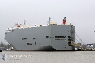
BALTIMORE HIGHWAY
Vehicles Carrier
Current Trip
| Time Travelled | 1 day |
|---|---|
| Remaining Time | 8 h, 35 mins |
| Distance Travelled | 450.69 nm |
| Remaining Distance | 521.90 nm |
| AVG Speed | 14.1 Knots |
| MAX Speed | 18 Knots |
| AVG Wind | 12.6 knots |
| MAX Wind | 18.5 knots |
| MIN Temp | 25.5°C / 77.9°F |
| MAX Temp | 28.2°C / 82.76°F |
| Draught | 7.7 m |
| Position Received | 1 d ago |
Current Position
| Longitude | --- |
|---|---|
| Latitude | --- |
| Status | Under way using engine |
| Speed | 16.2 Knots |
| Course | 81.8° |
| Area | Singapore Strait |
| Station | T-AIS |
| Position Received | 1 d ago |
Info
Information
The current position of BALTIMORE HIGHWAY is in Singapore Strait with coordinates 1.25235° / 104.15158° as reported on 2024-12-18 20:25 by AIS to our vessel tracker app. The vessel's current speed is 16.2 Knots and is heading at the port of JAKARTA. The estimated time of arrival as calculated by MyShipTracking vessel tracking app is 2024-12-20 06:40 LT
The vessel BALTIMORE HIGHWAY (IMO: 9510149, MMSI: 352517000) is a Vehicles Carrier that was built in 2009 ( 15 years old ). It's sailing under the flag of [PA] Panama.
In this page you can find informations about the vessels current position, last detected port calls, and current voyage information. If the vessels is not in coverage by AIS you will find the latest position.
The current position of BALTIMORE HIGHWAY is detected by our AIS receivers and we are not responsible for the reliability of the data. The last position was recorded while the vessel was in Coverage by the Ais receivers of our vessel tracking app.
The current draught of BALTIMORE HIGHWAY as reported by AIS is 7.7 meters
Weather
| Temperature | 28.1°C / 82.58°F |
|---|---|
| Wind Speed | 18 knots |
| Direction | 275° W |
| Pressure | 1006 hPa |
| Humidity | 80.3 % |
| Cloud Coverage | 100 % |
Featured Company
Last Port Calls
| Port | Arrival | Departure | Time In Port |
|---|---|---|---|
| 2024-12-17 23:49 | 2024-12-18 18:12 | 18 h | |
| 2024-12-14 23:04 | 2024-12-15 17:17 | 18 h | |
| 2024-12-08 01:45 | 2024-12-08 21:40 | 19 h | |
| 2024-12-02 11:01 | 2024-12-02 17:24 | 6 h | |
| 2024-11-26 21:14 | 2024-11-27 11:29 | 14 h | |
| 2024-11-23 10:03 | 2024-11-24 18:23 | 1 d | |
| 2024-11-19 23:53 | 2024-11-20 18:58 | 19 h | |
| 2024-11-16 23:04 | 2024-11-17 17:08 | 18 h | |
| 2024-11-02 13:22 | 2024-11-02 19:45 | 6 h | |
| 2024-10-31 08:17 | 2024-11-01 08:41 | 1 d |
Last Trips
| Origin | Departure | Destination | Arrival | Distance | |
|---|---|---|---|---|---|
| 2024-12-16 00:17 | 2024-12-18 07:49 | 847.62 nm | |||
| 2024-12-09 04:40 | 2024-12-15 06:04 | 1621.87 nm | |||
| 2024-12-03 00:24 | 2024-12-08 08:45 | 1697.17 nm | |||
| 2024-11-27 19:29 | 2024-12-02 18:01 | 1447.77 nm | |||
| 2024-11-25 01:23 | 2024-11-27 05:14 | 776.44 nm | |||
| 2024-11-21 02:58 | 2024-11-23 17:03 | 764.84 nm | |||
| 2024-11-18 00:08 | 2024-11-20 07:53 | 838.90 nm | |||
| 2024-11-02 22:45 | 2024-11-17 06:04 | 4730.04 nm | |||
| 2024-11-01 12:41 | 2024-11-02 16:22 | 345.89 nm | |||
| 2024-10-31 08:21 | 2024-10-31 12:17 | 51.01 nm |
Events
| Time | Event | Details | Position / Dest | Info |
|---|---|---|---|---|
| 2024-12-18 20:33 | Status Changed | Default Under way using engine |
1.25706 / 104.18493
IDJKT
|
Speed: 16.2 kn Course: 81.8° |
| 2024-12-18 20:25 | Status Changed | Under way using engine Default |
1.25235 / 104.15158
IDJKT
|
Speed: 16.1 kn Course: 82° |
| 2024-12-18 20:25 | OUT of Coverage |
1.25235 / 104.15158
Singapore Strait
IDJKT
|
Speed: 16.2 kn Course: 81.8° |
|
| 2024-12-18 20:21 | Status Changed | Default Under way using engine |
1.24964 / 104.13203
IDJKT
|
Speed: 16.3 kn Course: 83° |
| 2024-12-18 20:14 | Status Changed | Under way using engine Default |
1.24594 / 104.10350
IDJKT
|
Speed: 16.2 kn Course: 83° |
| 2024-12-18 20:13 | Status Changed | Default Under way using engine |
1.24505 / 104.09629
IDJKT
|
Speed: 16 kn Course: 82.7° |
| 2024-12-18 19:23 | ETA Changed | 2024/12/20 20:30 2024/12/20 19:30 |
1.20189 / 103.88328
IDJKT
|
Speed: 15 kn Course: 76.5° |
| 2024-12-18 19:10 | Change Sea Area | Indonesian part of the Singapore Strait Singaporean part of the Singapore Strait |
1.18639 / 103.83978
Singapore Strait
IDJKT
|
Speed: 10 kn Course: 70.6° |
| 2024-12-18 18:12 | PORT DEPARTURE |
|
1.28000 / 103.74633
IDJKT
|
Speed: 5.1 kn Course: 182° |
| 2024-12-18 18:10 | START Moving |
1.28366 / 103.74753
[SG] SINGAPORE
|
Speed: 4.5 kn Course: 204° |