
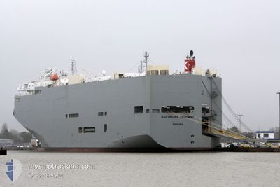
BALTIMORE HIGHWAY
Vehicles Carrier
Current Trip
| Time Travelled | 2 days |
|---|---|
| Remaining Time | 11 h, 49 mins |
| Distance Travelled | 727.82 nm |
| Remaining Distance | 424.48 nm |
| AVG Speed | 15.9 Knop |
| MAX Speed | 18.9 Knop |
| AVG Wind | 15.7 knots |
| MAX Wind | 25.8 knots |
| MIN Temp | 19°C / 66.2°F |
| MAX Temp | 27°C / 80.6°F |
| Djupgående | 7.4 m |
| Position mottagen | 2 d sen |
Current Position
| Longitud | --- |
|---|---|
| Latitude | --- |
| Status | Under way using engine |
| Fart | 6.1 Knop |
| Kurs | 234.3° |
| Område | South China Sea |
| Station | T-AIS |
| Position mottagen | 2 d sen |
Info
Information
The current position of BALTIMORE HIGHWAY is in South China Sea with coordinates 20.64577° / 106.87999° as reported on 2025-03-05 09:45 by AIS to our vessel tracker app. The vessel's current speed is 6.1 Knop and is heading at the port of LAEM CHABANG. The estimated time of arrival as calculated by MyShipTracking vessel tracking app is 2025-03-08 14:47 LT
The vessel BALTIMORE HIGHWAY (IMO: 9510149, MMSI: 352517000) is a Vehicles Carrier that was built in 2009 ( 16 År gammal ). It's sailing under the flag of [PA] Panama.
In this page you can find informations about the vessels current position, last detected port calls, and current voyage information. If the vessels is not in coverage by AIS you will find the latest position.
The current position of BALTIMORE HIGHWAY is detected by our AIS receivers and we are not responsible for the reliability of the data. The last position was recorded while the vessel was in Coverage by the Ais receivers of our vessel tracking app.
The current draught of BALTIMORE HIGHWAY as reported by AIS is 7.4 meters
Weather
| Temperature | 27.9°C / 82.22°F |
|---|---|
| Wind Speed | 20 knots |
| Direction | 100° E |
| Pressure | 1010.4 hPa |
| Humidity | 76.4 % |
| Cloud Coverage | 100 % |
Featured Company
Last Port Calls
| Port | Arrival | Departure | Time In Port |
|---|---|---|---|
| 2025-03-04 05:32 | 2025-03-05 07:33 | 1 d | |
| 2025-02-26 02:05 | 2025-02-26 16:13 | 14 h | |
| 2025-02-20 09:49 | 2025-02-20 22:33 | 12 h | |
| 2025-02-16 23:12 | 2025-02-18 11:52 | 1 d | |
| 2025-02-13 08:01 | 2025-02-14 09:57 | 1 d | |
| 2025-02-11 16:54 | 2025-02-12 16:40 | 23 h | |
| 2025-02-08 22:41 | 2025-02-09 17:29 | 18 h | |
| 2025-02-01 23:48 | 2025-02-03 01:59 | 1 d | |
| 2025-01-27 05:13 | 2025-01-27 17:17 | 12 h | |
| 2025-01-19 21:00 | 2025-01-21 16:12 | 1 d |
Last Trips
| Origin | Departure | Destination | Arrival | Distance | |
|---|---|---|---|---|---|
| 2025-02-26 23:13 | 2025-03-04 12:32 | 1710.45 nm | |||
| 2025-02-21 06:33 | 2025-02-26 09:05 | 1493.88 nm | |||
| 2025-02-18 18:52 | 2025-02-20 17:49 | 781.86 nm | |||
| 2025-02-14 17:57 | 2025-02-17 06:12 | 973.10 nm | |||
| 2025-02-13 00:40 | 2025-02-13 16:01 | 205.48 nm | |||
| 2025-02-10 00:29 | 2025-02-12 00:54 | 830.87 nm | |||
| 2025-02-03 08:59 | 2025-02-09 05:41 | 1487.06 nm | |||
| 2025-01-28 00:17 | 2025-02-02 06:48 | 1617.16 nm | |||
| 2025-01-21 23:12 | 2025-01-27 12:13 | 1939.55 nm | |||
| 2025-01-17 14:45 | 2025-01-20 04:00 | 963.62 nm |
Events
| Tid | Event | Detaljer | Position / Dest | Information |
|---|---|---|---|---|
| 2025-03-05 09:48 | Status ändrad | Default Under way using engine |
20.64155 / 106.87650
TH LCH
|
Fart: 6.1 kn Kurs: 234.3° |
| 2025-03-05 09:45 | UTANFÖR täckningsområde |
20.64577 / 106.87999
South China Sea
TH LCH
|
Fart: 6.1 kn Kurs: 234.3° |
|
| 2025-03-05 08:17 | Status ändrad | Under way using engine Default |
20.81909 / 106.88427
TH LCH
|
Fart: 9.8 kn Kurs: 82° |
| 2025-03-05 08:13 | Status ändrad | Default Under way using engine |
20.81759 / 106.87274
TH LCH
|
Fart: 9.5 kn Kurs: 82.5° |
| 2025-03-05 08:07 | Status ändrad | Under way using engine Default |
20.81543 / 106.85572
TH LCH
|
Fart: 9.4 kn Kurs: 83° |
| 2025-03-05 08:05 | Status ändrad | Default Under way using engine |
20.81492 / 106.85148
TH LCH
|
Fart: 8.8 kn Kurs: 138.1° |
| 2025-03-05 07:51 | Status ändrad | Under way using engine Default |
20.82999 / 106.82203
TH LCH
|
Fart: 7.9 kn Kurs: 100° |
| 2025-03-05 07:50 | Status ändrad | Default Under way using engine |
20.83097 / 106.81868
TH LCH
|
Fart: 7 kn Kurs: 87.9° |
| 2025-03-05 07:43 | Status ändrad | Under way using engine Default |
20.83127 / 106.80443
TH LCH
|
Fart: 6.6 kn Kurs: 88° |
| 2025-03-05 07:41 | Status ändrad | Default Under way using engine |
20.83114 / 106.80084
TH LCH
|
Fart: 6.5 kn Kurs: 89.8° |