

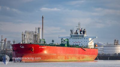
STI SANCTITY
Tanker

Current Trip
| Time Travelled | 9 days |
|---|---|
| Remaining Time | --- |
| Distance Travelled | 1306.72 nm |
| Remaining Distance | --- |
| AVG Speed | 10.5 Knop |
| MAX Speed | 13.8 Knop |
| AVG Wind | 10.8 knots |
| MAX Wind | 29 knots |
| MIN Temp | 15.3°C / 59.54°F |
| MAX Temp | 28°C / 82.4°F |
| Djupgående | 13.6 m |
| Position mottagen | 3 d sen |
Current Position
| Longitud | --- |
|---|---|
| Latitude | --- |
| Status | Under way using engine |
| Fart | 0.6 Knop |
| Kurs | 27° |
| Område | Mediterranean Sea - Eastern Basin |
| Station | T-AIS |
| Position mottagen | 3 d sen |
Information
The current position of STI SANCTITY is in Mediterranean Sea - Eastern Basin with coordinates 36.21916° / 22.30814° as reported on 2025-03-15 04:59 by AIS to our vessel tracker app. The vessel's current speed is 0.6 Knop and is heading at the port of KALAMATA. The estimated time of arrival as calculated by MyShipTracking vessel tracking app is 2025-03-15 02:01 LT
The vessel STI SANCTITY (IMO: 9719707, MMSI: 538006078) is a Tanker It's sailing under the flag of [MH] Marshall Is.
In this page you can find informations about the vessels current position, last detected port calls, and current voyage information. If the vessels is not in coverage by AIS you will find the latest position.
The current position of STI SANCTITY is detected by our AIS receivers and we are not responsible for the reliability of the data. The last position was recorded while the vessel was in Coverage by the Ais receivers of our vessel tracking app.
The current draught of STI SANCTITY as reported by AIS is 13.6 meters
Weather
| Temperature | 14.7°C / 58.46°F |
|---|---|
| Wind Speed | 12 knots |
| Direction | 325° NW |
| Pressure | 1017.6 hPa |
| Humidity | 67.8 % |
| Cloud Coverage | 64 % |


Featured Company
Last Port Calls
| Port | Arrival | Departure | Time In Port |
|---|---|---|---|
| 2025-03-12 08:36 | 2025-03-12 18:00 | 9 h | |
| 2025-03-08 12:59 | 2025-03-09 11:41 | 22 h | |
| 2025-03-04 07:01 | 2025-03-04 16:20 | 9 h | |
| 2025-02-13 01:52 | 2025-02-14 14:31 | 1 d | |
| 2025-02-09 09:18 | 2025-02-09 18:57 | 9 h | |
| 2025-02-05 12:28 | 2025-02-06 15:26 | 1 d | |
| 2025-01-30 08:44 | 2025-01-30 17:50 | 9 h | |
| 2025-01-09 17:12 | 2025-01-12 12:03 | 2 d |
Most Visited Ports (Last year)
| Port | Arrivals | |
|---|---|---|
| 4 | ||
| 2 | ||
| 2 | ||
| 2 | ||
| 2 | ||
| 1 |
Last Trips
| Origin | Departure | Destination | Arrival | Distance | |
|---|---|---|---|---|---|
| 2025-03-09 11:41 | 2025-03-12 08:36 | 511.71 nm | |||
| 2025-02-14 14:31 | 2025-03-08 12:59 | 3196.83 nm | |||
| 2025-02-14 14:31 | 2025-03-04 07:01 | 2523.86 nm | |||
| 2025-02-06 15:26 | 2025-02-13 01:52 | 1545.87 nm | |||
| 2025-02-06 15:26 | 2025-02-09 09:18 | 511.10 nm | |||
| 2025-01-12 12:03 | 2025-02-05 12:28 | 4235.44 nm | |||
| 2025-01-12 12:03 | 2025-01-30 08:44 | 3406.61 nm | |||
| 2024-11-27 22:06 | 2025-01-09 17:12 | 10914.20 nm |
Events
| Tid | Event | Detaljer | Position / Dest | Information |
|---|---|---|---|---|
| 2025-03-18 07:30 | STARTAR förflyttning | 13.8 nm, South East of KOTRONAS |
36.41724 / 22.63444
KALAMATA
|
Fart: 3.5 kn Kurs: 232° |
| 2025-03-18 01:31 | STOPPAR förflyttning | 15.11 nm, South East of KOTRONAS |
36.39410 / 22.63819
KALAMATA
|
Fart: 0.3 kn Kurs: 20° |
| 2025-03-17 05:23 | STARTAR förflyttning | 14.81 nm, West of PLATIA AMMOS |
36.38076 / 22.65682
KALAMATA
|
Fart: 3.2 kn Kurs: 75° |
| 2025-03-16 09:03 | STOPPAR förflyttning | 14.35 nm, West of PLATIA AMMOS |
36.42840 / 22.67623
KALAMATA
|
Fart: 0.3 kn Kurs: 340° |
| 2025-03-16 00:04 | STARTAR förflyttning | 21.23 nm, South West of PLATIA AMMOS |
36.21890 / 22.56283
KALAMATA
|
Fart: 3.5 kn Kurs: 108° |
| 2025-03-15 13:56 | STOPPAR förflyttning |
36.17717 / 22.50956
KALAMATA
|
Fart: 0.1 kn Kurs: 48° |
|
| 2025-03-15 11:30 | STARTAR förflyttning |
36.26070 / 22.25252
KALAMATA
|
Fart: 3.9 kn Kurs: 124° |
|
| 2025-03-15 05:08 | Status ändrad | Default Under way using engine |
36.21985 / 22.30659
KALAMATA
|
Fart: 0.6 kn Kurs: 27° |
| 2025-03-15 04:59 | UTANFÖR täckningsområde |
36.21916 / 22.30814
Mediterranean Sea - Eastern Basin
|
Fart: 0.6 kn Kurs: 295.9° |
|
| 2025-03-15 04:44 | Status ändrad | Under way using engine Default |
36.21823 / 22.31066
KALAMATA
|
Fart: 0.5 kn Kurs: 20° |