
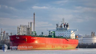
STI SANCTITY
Tanker
Current Trip
| Time Travelled | 13 days |
|---|---|
| Remaining Time | --- |
| Distance Travelled | 3057.37 nm |
| Remaining Distance | --- |
| AVG Speed | 11.6 Noeuds |
| MAX Speed | 15.2 Noeuds |
| AVG Wind | 11.1 knots |
| MAX Wind | 21 knots |
| MIN Temp | 4.6°C / 40.28°F |
| MAX Temp | 17.7°C / 63.86°F |
| Tirant d eau | 9.2 m |
| Position reçue | 2 d depuis |
Current Position
| Longitude | --- |
|---|---|
| Latitude | --- |
| Etat | Under way using engine |
| Vitesse | 12.6 Noeuds |
| Parcours | 105.6° |
| Zone | Mediterranean Sea - Eastern Basin |
| Station | T-AIS |
| Position reçue | 2 d depuis |
Info
Information
The current position of STI SANCTITY is in Mediterranean Sea - Eastern Basin with coordinates 33.98066° / 24.53919° as reported on 2025-01-23 09:21 by AIS to our vessel tracker app. The vessel's current speed is 12.6 Noeuds
The vessel STI SANCTITY (IMO: 9719707, MMSI: 538006078) is a Tanker It's sailing under the flag of [MH] Marshall Is.
In this page you can find informations about the vessels current position, last detected port calls, and current voyage information. If the vessels is not in coverage by AIS you will find the latest position.
The current position of STI SANCTITY is detected by our AIS receivers and we are not responsible for the reliability of the data. The last position was recorded while the vessel was in Coverage by the Ais receivers of our vessel tracking app.
The current draught of STI SANCTITY as reported by AIS is 9.2 meters
Weather
| Temperature | 17.5°C / 63.5°F |
|---|---|
| Wind Speed | 5 knots |
| Direction | 273° W |
| Pressure | 1019.1 hPa |
| Humidity | 67.6 % |
| Cloud Coverage | --- |
Featured Company
Last Port Calls
| Port | Arrival | Departure | Time In Port |
|---|---|---|---|
| 2025-01-09 16:12 | 2025-01-12 11:03 | 2 d | |
| 2024-11-26 09:16 | 2024-11-27 19:06 | 1 d |
Most Visited Ports (Last year)
| Port | Arrivals | |
|---|---|---|
| 2 | ||
| 2 | ||
| 2 | ||
| 2 | ||
| 1 | ||
| 1 |
Last Trips
| Origin | Departure | Destination | Arrival | Distance | |
|---|---|---|---|---|---|
| 2024-11-27 22:06 | 2025-01-09 17:12 | 10914.20 nm | |||
| 2024-10-10 23:05 | 2024-11-26 12:16 | 11942.10 nm |
Events
| Heure | Evenement | Détails | Position/ Destination | Info |
|---|---|---|---|---|
| 2025-01-23 09:32 | Etat Changé | Default Under way using engine |
33.97036 / 24.58496
EG PSD
|
Vitesse: 12.6 kn Parcours: 105.6° |
| 2025-01-23 09:21 | Etat Changé | Under way using engine Default |
33.98066 / 24.53919
EG PSD
|
Vitesse: 12.6 kn Parcours: 108° |
| 2025-01-23 09:21 | Hors de la zone couverte |
33.98066 / 24.53919
Mediterranean Sea - Eastern Basin
EG PSD
|
Vitesse: 12.6 kn Parcours: 105.6° |
|
| 2025-01-23 09:12 | Etat Changé | Default Under way using engine |
33.98896 / 24.50613
EG PSD
|
Vitesse: 12.5 kn Parcours: 108.6° |
| 2025-01-23 09:09 | Dans la zone couverte |
33.99272 / 24.49208
Mediterranean Sea - Eastern Basin
EG PSD
|
Vitesse: 12.5 kn Parcours: 108.6° |
|
| 2025-01-23 04:34 | Etat Changé | Default Under way using engine |
34.25368 / 23.36097
EG PSD
|
Vitesse: 13.1 kn Parcours: 104.2° |
| 2025-01-23 04:19 | Hors de la zone couverte |
34.26822 / 23.29642
Mediterranean Sea - Eastern Basin
EG PSD
|
Vitesse: 13.1 kn Parcours: 104.2° |
|
| 2025-01-23 04:03 | Etat Changé | Under way using engine Default |
34.28247 / 23.22648
EG PSD
|
Vitesse: 13.3 kn Parcours: 111° |
| 2025-01-23 03:33 | Etat Changé | Default Under way using engine |
34.31745 / 23.09954
EG PSD
|
Vitesse: 13 kn Parcours: 106.3° |
| 2025-01-23 02:57 | Changement de destination | EG PSD MALTA |
34.35445 / 22.94346
EG PSD
|
Vitesse: 13 kn Parcours: 106.3° |