
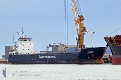
PROUD
General Cargo
Current Trip
| Time Travelled | 7 days |
|---|---|
| Remaining Time | --- |
| Distance Travelled | 1472.14 nm |
| Remaining Distance | --- |
| AVG Speed | 8.8 Knop |
| MAX Speed | 11.4 Knop |
| AVG Wind | 12.5 knots |
| MAX Wind | 26.1 knots |
| MIN Temp | 9.3°C / 48.74°F |
| MAX Temp | 20.1°C / 68.18°F |
| Djupgående | 6.6 m |
| Position mottagen | 1 d sen |
Current Position
| Longitud | -8.71584° |
|---|---|
| Latitude | 33.11362° |
| Status | Under way using engine |
| Fart | 2.2 Knop |
| Kurs | 81° |
| Område | North Atlantic Ocean |
| Station | T-AIS |
| Position mottagen | 1 d sen |
Info
Information
The current position of PROUD is in North Atlantic Ocean with coordinates 33.11362° / -8.71584° as reported on 2024-05-05 16:12 by AIS to our vessel tracker app. The vessel's current speed is 2.2 Knop
The vessel PROUD (IMO: 9386433, MMSI: 246611000) is a General Cargo that was built in 2009 ( 15 År gammal ). It's sailing under the flag of [NL] Netherlands.
In this page you can find informations about the vessels current position, last detected port calls, and current voyage information. If the vessels is not in coverage by AIS you will find the latest position.
The current position of PROUD is detected by our AIS receivers and we are not responsible for the reliability of the data. The last position was recorded while the vessel was in Coverage by the Ais receivers of our vessel tracking app.
The current draught of PROUD as reported by AIS is 6.6 meters
Weather
| Temperature | 19.1°C / 66.38°F |
|---|---|
| Wind Speed | 16 knots |
| Direction | 27° NNE |
| Pressure | 1015.1 hPa |
| Humidity | 84.9 % |
| Cloud Coverage | --- |
Featured Company
Last Port Calls
| Port | Arrival | Departure | Time In Port |
|---|---|---|---|
| 2024-04-24 20:04 | 2024-04-28 21:00 | 4 d | |
| 2024-04-22 14:12 | 2024-04-24 10:40 | 1 d | |
| 2024-04-18 21:58 | 2024-04-20 16:19 | 1 d | |
| 2024-04-16 17:26 | 2024-04-17 23:47 | 1 d | |
| 2024-04-11 03:56 | 2024-04-13 15:20 | 2 d | |
| 2024-04-05 23:37 | 2024-04-11 03:17 | 5 d | |
| 2024-04-03 22:24 | 2024-04-05 23:09 | 2 d | |
| 2024-04-02 12:52 | 2024-04-03 21:49 | 1 d | |
| 2024-03-30 08:23 | 2024-04-01 05:21 | 1 d | |
| 2024-03-26 21:55 | 2024-03-29 15:38 | 2 d |
Last Trips
| Origin | Departure | Destination | Arrival | Distance | |
|---|---|---|---|---|---|
| 2024-04-24 12:40 | 2024-04-24 22:04 | 68.63 nm | |||
| 2024-04-20 17:19 | 2024-04-22 16:12 | 384.88 nm | |||
| 2024-04-18 00:47 | 2024-04-18 22:58 | 234.36 nm | |||
| 2024-04-13 17:20 | 2024-04-16 18:26 | 609.80 nm | |||
| 2024-04-11 05:17 | 2024-04-11 05:56 | 3.20 nm | |||
| 2024-04-06 01:09 | 2024-04-06 01:37 | 3.30 nm | |||
| 2024-04-03 23:49 | 2024-04-04 00:24 | 3.27 nm | |||
| 2024-04-01 06:21 | 2024-04-02 14:52 | 273.85 nm | |||
| 2024-03-29 15:38 | 2024-03-30 08:23 | 122.06 nm | |||
| 2024-03-24 19:32 | 2024-03-26 21:55 | 409.43 nm |
Events
| Tid | Event | Detaljer | Position / Dest | Information |
|---|---|---|---|---|
| 2024-05-05 16:18 | Status ändrad | Default Under way using engine |
33.11167 / -8.71333
MAJFL
|
Fart: 2.2 kn Kurs: 81° |
| 2024-05-05 16:18 | STOPPAR förflyttning | 4.16 nm, West of JORF LASFAR |
33.11167 / -8.71333
MAJFL
|
Fart: Kurs: -1° |
| 2024-05-05 16:12 | Status ändrad | Under way using engine Default |
33.11362 / -8.71584
MAJFL
|
Fart: 3 kn Kurs: -1° |
| 2024-05-05 16:12 | UTANFÖR täckningsområde |
33.11362 / -8.71584
North Atlantic Ocean
MAJFL
|
Fart: 2.2 kn Kurs: 165.7° |
|
| 2024-05-05 15:45 | Status ändrad | Default Under way using engine |
33.16000 / -8.74667
MAJFL
|
Fart: 9.2 kn Kurs: 137.4° |
| 2024-05-05 15:38 | Byter havsområde | Moroccan part of the North Atlantic Ocean Portuguese part of the North Atlantic Ocean |
33.17041 / -8.76352
North Atlantic Ocean
MAJFL
|
Fart: 9.2 kn Kurs: 137.4° |
| 2024-05-05 15:38 | Status ändrad | Under way using engine Default |
33.17041 / -8.76352
MAJFL
|
Fart: 9 kn Kurs: 166° |
| 2024-05-05 15:38 | I täckningsområde |
33.17041 / -8.76352
North Atlantic Ocean
MAJFL
|
Fart: 9.2 kn Kurs: 137.4° |
|
| 2024-05-04 22:36 | Status ändrad | Default Under way using engine |
35.70167 / -9.48833
MAJFL
|
Fart: 9.1 kn Kurs: 164° |
| 2024-05-04 22:26 | UTANFÖR täckningsområde |
35.73615 / -9.49923
North Atlantic Ocean
MAJFL
|
Fart: 9.1 kn Kurs: 164° |