
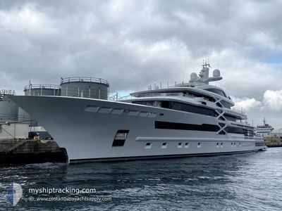
PROJECT-X
Pleasure Craft
Current Trip
| Time Travelled | 2 days |
|---|---|
| Remaining Time | --- |
| Distance Travelled | 61.96 nm |
| Remaining Distance | --- |
| AVG Speed | 9.9 Knop |
| MAX Speed | 14.4 Knop |
| AVG Wind | 2.1 knots |
| MAX Wind | 8.6 knots |
| MIN Temp | 16.8°C / 62.24°F |
| MAX Temp | 20.3°C / 68.54°F |
| Djupgående | 4.5 m |
| Position mottagen | 7 m sen |
Current Position
| Longitud | 20.36021° |
|---|---|
| Latitude | 38.86651° |
| Status | At anchor |
| Fart | 13.9 Knop |
| Kurs | 165.8° |
| Område | Ionian Sea |
| Station | T-AIS |
| Position mottagen | 7 m sen |
Info
Information
The current position of PROJECT-X is in Ionian Sea with coordinates 38.86651° / 20.36021° as reported on 2024-05-01 04:50 by AIS to our vessel tracker app. The vessel's current speed is 13.9 Knop
The vessel PROJECT-X (IMO: 1010727, MMSI: 229063000) is a Pleasure Craft It's sailing under the flag of [MT] Malta.
In this page you can find informations about the vessels current position, last detected port calls, and current voyage information. If the vessels is not in coverage by AIS you will find the latest position.
The current position of PROJECT-X is detected by our AIS receivers and we are not responsible for the reliability of the data. The last position was recorded while the vessel was in Coverage by the Ais receivers of our vessel tracking app.
The current draught of PROJECT-X as reported by AIS is 4.5 meters
Weather
| Temperature | 18.7°C / 65.66°F |
|---|---|
| Wind Speed | 11 knots |
| Direction | 157° SSE |
| Pressure | 1015.1 hPa |
| Humidity | 78.2 % |
| Cloud Coverage | 38 % |
Featured Company
Last Port Calls
| Port | Arrival | Departure | Time In Port |
|---|---|---|---|
| 2024-04-28 03:58 | 2024-04-28 08:56 | 4 h | |
| 2024-04-10 07:27 | 2024-04-10 19:59 | 12 h |
Last Trips
| Origin | Departure | Destination | Arrival | Distance | |
|---|---|---|---|---|---|
| 2024-04-10 22:59 | 2024-04-28 05:58 | 745.47 nm | |||
| 2024-02-15 20:02 | 2024-04-10 10:27 | 365.44 nm |
Events
| Tid | Event | Detaljer | Position / Dest | Information |
|---|---|---|---|---|
| 2024-05-01 04:36 | Destination ändrad | KEFALONIA CORFU |
38.92244 / 20.34256
KEFALONIA
|
Fart: 13.7 kn Kurs: 167.2° |
| 2024-05-01 04:36 | ETA ändrat | 2024/05/01 07:00 2024/04/28 11:00 |
38.92244 / 20.34256
KEFALONIA
|
Fart: 13.7 kn Kurs: 167.2° |
| 2024-05-01 03:23 | I täckningsområde |
39.16248 / 20.23808
Ionian Sea
|
Fart: 7.1 kn Kurs: 76° |
|
| 2024-04-30 09:55 | UTANFÖR täckningsområde |
39.16040 / 20.22973
Ionian Sea
|
Fart: 0.1 kn Kurs: 149.3° |
|
| 2024-04-30 07:27 | Status ändrad | At anchor Under way using engine |
39.16089 / 20.22997
CORFU
|
Fart: 0.2 kn Kurs: 23° |
| 2024-04-30 06:39 | STOPPAR förflyttning | 0.49 nm, North of ANTIPAXOS |
39.16132 / 20.23016
CORFU
|
Fart: 0.2 kn Kurs: 255° |
| 2024-04-30 05:34 | Byter havsområde | Greek part of the Ionian Sea Albanian part of the Adriatic Sea |
39.38858 / 20.15983
Ionian Sea
|
Fart: 14.3 kn Kurs: 145° |
| 2024-04-30 05:33 | I täckningsområde |
39.38858 / 20.15983
Ionian Sea
|
Fart: 14.3 kn Kurs: 145° |
|
| 2024-04-28 09:33 | UTANFÖR täckningsområde |
39.78985 / 19.97896
Adriatic Sea
CORFU
|
Fart: 12.5 kn Kurs: 178.2° |
|
| 2024-04-28 08:56 | AVGÅTT HAMN |
|
39.86788 / 19.99085
CORFU
|
Fart: 5.2 kn Kurs: 187° |