

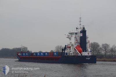
KAILEEN
General Cargo

Current Trip
| Time Travelled | 20 h, 7 mins |
|---|---|
| Remaining Time | 1 day |
| Distance Travelled | 164.04 nm |
| Remaining Distance | 350.60 nm |
| AVG Speed | 11.1 Knop |
| MAX Speed | 12.4 Knop |
| AVG Wind | 6.1 knots |
| MAX Wind | 8 knots |
| MIN Temp | 9.8°C / 49.64°F |
| MAX Temp | 12.6°C / 54.68°F |
| Djupgående | 5.6 m |
| Position mottagen | 6 h, 38 m sen |
Current Position
| Longitud | --- |
|---|---|
| Latitude | --- |
| Status | Under way using engine |
| Fart | 11 Knop |
| Kurs | 274.3° |
| Område | Bay of Biscay |
| Station | T-AIS |
| Position mottagen | 6 h, 38 m sen |
Information
The current position of KAILEEN is in Bay of Biscay with coordinates 43.81951° / -6.05273° as reported on 2025-03-28 07:04 by AIS to our vessel tracker app. The vessel's current speed is 11 Knop and is heading at the port of AVEIRO. The estimated time of arrival as calculated by MyShipTracking vessel tracking app is 2025-03-29 14:50 LT
The vessel KAILEEN (IMO: 9229049, MMSI: 305922000) is a General Cargo that was built in 2001 ( 24 År gammal ). It's sailing under the flag of [AG] Antigua Barbuda.
In this page you can find informations about the vessels current position, last detected port calls, and current voyage information. If the vessels is not in coverage by AIS you will find the latest position.
The current position of KAILEEN is detected by our AIS receivers and we are not responsible for the reliability of the data. The last position was recorded while the vessel was in Coverage by the Ais receivers of our vessel tracking app.
The current draught of KAILEEN as reported by AIS is 5.6 meters
Weather
| Temperature | 12.8°C / 55.04°F |
|---|---|
| Wind Speed | 7 knots |
| Direction | 261° W |
| Pressure | 1023.3 hPa |
| Humidity | 77.8 % |
| Cloud Coverage | 59 % |


Featured Company
Last Port Calls
| Port | Arrival | Departure | Time In Port |
|---|---|---|---|
| 2025-03-25 09:48 | 2025-03-27 18:36 | 2 d | |
| 2025-03-21 02:42 | 2025-03-21 03:26 | 44 m | |
| 2025-03-13 18:14 | 2025-03-17 13:57 | 3 d | |
| 2025-03-13 17:10 | |||
| 2025-03-13 17:06 | |||
| 2025-03-05 21:50 | 2025-03-11 00:11 | 5 d | |
| 2025-02-21 04:56 | 2025-02-27 17:59 | 6 d | |
| 2025-02-21 04:26 | 2025-02-21 04:38 | 11 m | |
| 2025-02-15 03:13 | 2025-02-16 21:43 | 1 d | |
| 2025-02-12 19:42 | 2025-02-12 19:54 | 11 m |
Most Visited Ports (Last year)
| Port | Arrivals | |
|---|---|---|
| 14 | ||
| 5 | ||
| 5 | ||
| 3 | ||
| 3 | ||
| 3 |
Last Trips
| Origin | Departure | Destination | Arrival | Distance | |
|---|---|---|---|---|---|
| 2025-03-21 03:26 | 2025-03-25 09:48 | 1025.74 nm | |||
| 2025-03-17 13:57 | 2025-03-21 02:42 | 834.60 nm | |||
| 2025-03-13 17:06 | 2025-03-13 18:14 | 12.33 nm | |||
| 2025-03-11 00:11 | 2025-03-13 17:10 | 691.25 nm | |||
| 2025-02-27 17:59 | 2025-03-05 21:50 | 592.30 nm | |||
| 2025-02-21 04:38 | 2025-02-21 04:56 | 0.08 nm | |||
| 2025-02-16 21:43 | 2025-02-21 04:26 | 152.15 nm | |||
| 2025-02-12 19:54 | 2025-02-15 03:13 | 278.40 nm | |||
| 2025-01-22 18:04 | 2025-02-12 19:42 | 2676.64 nm | |||
| 2025-01-22 18:04 | 2025-02-12 02:28 | 2676.36 nm |
Events
| Tid | Event | Detaljer | Position / Dest | Information |
|---|---|---|---|---|
| 2025-03-28 07:12 | Status ändrad | Default Under way using engine |
43.82141 / -6.08788
PTAVE
|
Fart: 11 kn Kurs: 274.3° |
| 2025-03-28 07:04 | UTANFÖR täckningsområde |
43.81951 / -6.05273
Bay of Biscay
PTAVE
|
Fart: 11 kn Kurs: 274.3° |
|
| 2025-03-28 06:45 | Status ändrad | Under way using engine Default |
43.81511 / -5.97239
PTAVE
|
Fart: 11.3 kn Kurs: 275° |
| 2025-03-28 06:32 | Status ändrad | Default Under way using engine |
43.80744 / -5.91941
PTAVE
|
Fart: 11.1 kn Kurs: 286.2° |
| 2025-03-28 06:31 | Status ändrad | Under way using engine Default |
43.80686 / -5.91664
PTAVE
|
Fart: 11.2 kn Kurs: 286° |
| 2025-03-28 06:28 | Status ändrad | Default Under way using engine |
43.80410 / -5.90306
PTAVE
|
Fart: 11.1 kn Kurs: 285.5° |
| 2025-03-28 05:17 | Status ändrad | Under way using engine Default |
43.77337 / -5.60267
PTAVE
|
Fart: 11.1 kn Kurs: 276° |
| 2025-03-28 05:15 | Status ändrad | Default Under way using engine |
43.77283 / -5.59565
PTAVE
|
Fart: 11.1 kn Kurs: 274.5° |
| 2025-03-28 03:52 | Status ändrad | Under way using engine Default |
43.74752 / -5.24188
PTAVE
|
Fart: 11.3 kn Kurs: 276° |
| 2025-03-28 03:47 | Status ändrad | Default Under way using engine |
43.74560 / -5.21917
PTAVE
|
Fart: 11.4 kn Kurs: 275.1° |