
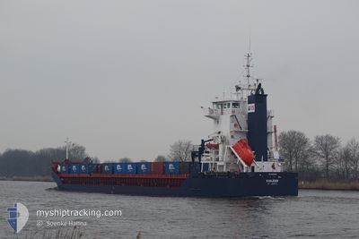
KAILEEN
General Cargo
Current Trip
| Trip Time | 2 days |
|---|---|
| Trip Distance | 531.91 nm |
| AVG Speed | 9.1 Knopen |
| MAX Speed | 12.4 Knopen |
| Diepgang | 4.4 M |
| AVG Wind | 7.8 knots |
| MAX Wind | 16.9 knots |
| MIN Temp | 1.9°C / 35.42°F |
| MAX Temp | 6.2°C / 43.16°F |
| Positie ontvangen | 3 d geleden |
Current Position
| Lengtegraad | 24.65452° |
|---|---|
| Breedtegraat | 59.46102° |
| Status | Moored |
| Snelheid | |
| Koers | 121° |
| Gebied | Gulf of Finland |
| Station | T-AIS |
| Positie ontvangen | 3 d geleden |
Info
Information
The current position of KAILEEN is in Gulf of Finland with coordinates 59.46102° / 24.65452° as reported on 2024-04-27 09:51 by AIS to our vessel tracker app. The vessel's current speed is 0 Knopen and is currently inside the port of VENE BALTI.
The vessel KAILEEN (IMO: 9229049, MMSI: 305922000) is a General Cargo that was built in 2001 ( 23 Jaar oud ). It's sailing under the flag of [AG] Antigua Barbuda.
In this page you can find informations about the vessels current position, last detected port calls, and current voyage information. If the vessels is not in coverage by AIS you will find the latest position.
The current position of KAILEEN is detected by our AIS receivers and we are not responsible for the reliability of the data. The last position was recorded while the vessel was in Coverage by the Ais receivers of our vessel tracking app.
The current draught of KAILEEN as reported by AIS is 4.4 meters
Weather
| Temperature | 7.1°C / 44.78°F |
|---|---|
| Wind Speed | 3 knots |
| Direction | 65° ENE |
| Pressure | 1018 hPa |
| Humidity | 66.7 % |
| Cloud Coverage | 9 % |
Featured Company
Last Port Calls
| Port | Arrival | Departure | Time In Port |
|---|---|---|---|
| 2024-04-26 04:04 | |||
| 2024-04-21 15:30 | 2024-04-23 19:07 | 2 d | |
| 2024-04-17 10:21 | 2024-04-18 02:57 | 16 h | |
| 2024-04-08 04:26 | 2024-04-10 13:54 | 2 d | |
| 2024-03-29 06:47 | 2024-04-04 18:17 | 6 d | |
| 2024-03-26 03:08 | 2024-03-26 03:11 | 2 m | |
| 2024-03-20 11:18 | 2024-03-21 13:43 | 1 d | |
| 2024-03-11 22:10 | 2024-03-14 16:01 | 2 d | |
| 2024-03-07 09:50 | 2024-03-07 11:12 | 1 h | |
| 2024-02-29 08:17 | 2024-03-04 11:19 | 4 d |
Last Trips
| Origin | Departure | Destination | Arrival | Distance | |
|---|---|---|---|---|---|
| 2024-04-23 21:07 | 2024-04-26 07:04 | 531.91 nm | |||
| 2024-04-18 05:57 | 2024-04-21 17:30 | 690.45 nm | |||
| 2024-04-10 15:54 | 2024-04-17 13:21 | 569.08 nm | |||
| 2024-04-04 21:17 | 2024-04-08 06:26 | 582.56 nm | |||
| 2024-03-26 04:11 | 2024-03-29 09:47 | 782.14 nm | |||
| 2024-03-21 13:43 | 2024-03-26 04:08 | 1021.09 nm | |||
| 2024-03-14 17:01 | 2024-03-20 11:18 | 685.19 nm | |||
| 2024-03-07 12:12 | 2024-03-11 23:10 | 1067.26 nm | |||
| 2024-03-04 14:19 | 2024-03-07 10:50 | 734.10 nm | |||
| 2024-02-28 10:10 | 2024-02-29 11:17 | 167.82 nm |
Events
| Tijd | Evenement | Details | Positie / Bestemming | Info |
|---|---|---|---|---|
| 2024-04-27 09:51 | Buitenbereik |
59.46102 / 24.65452
Gulf of Finland
[EE] VENE BALTI
|
Snelheid: Koers: 21.3° |
|
| 2024-04-27 01:06 | Status Changed | Moored Default |
59.46103 / 24.65456
[EE] VENE BALTI
|
Snelheid: Koers: 121° |
| 2024-04-27 01:00 | Status Changed | Default Moored |
59.46099 / 24.65445
[EE] VENE BALTI
|
Snelheid: Koers: 121° |
| 2024-04-26 04:12 | Status Changed | Moored Under way using engine |
59.46104 / 24.65440
[EE] VENE BALTI
|
Snelheid: Koers: 121° |
| 2024-04-26 04:06 | Stop beweging |
59.46079 / 24.65413
[EE] VENE BALTI
|
Snelheid: 0.3 kn Koers: 110° |
|
| 2024-04-26 04:04 | Aankomsthaven |
|
59.46066 / 24.65398
[EE] VENE BALTI
|
Snelheid: 0.6 kn Koers: 106° |
| 2024-04-25 22:50 | Status Changed | Under way using engine Default |
59.35231 / 23.39972
EETLL
|
Snelheid: 8.1 kn Koers: 72° |
| 2024-04-25 22:46 | Status Changed | Default Under way using engine |
59.34876 / 23.37858
EETLL
|
Snelheid: 8.1 kn Koers: 69.7° |
| 2024-04-25 22:37 | Gevonden in zee | Estonian part of the Gulf of Finland |
59.34309 / 23.34614
Gulf of Finland
EETLL
|
Snelheid: 8.1 kn Koers: 69.7° |
| 2024-04-25 20:36 | Wijzig zee gebeid | Estonian part of the Baltic Sea Swedish part of the Baltic Sea |
59.25413 / 22.81685
Baltic Sea
EETLL
|
Snelheid: 8.8 kn Koers: 68.4° |