

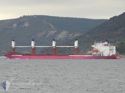
BR GLORY
Bulk Carrier

Current Trip
EG SCN
| Time Travelled | 1 day |
|---|---|
| Remaining Time | --- |
| Distance Travelled | 385.67 nm |
| Remaining Distance | --- |
| AVG Speed | 9.6 Knop |
| MAX Speed | 11 Knop |
| AVG Wind | 8.1 knots |
| MAX Wind | 16 knots |
| MIN Temp | 12.3°C / 54.14°F |
| MAX Temp | 17.8°C / 64.04°F |
| Djupgående | 5.5 m |
| Position mottagen | 11 d sen |
Current Position
| Longitud | --- |
|---|---|
| Latitude | --- |
| Status | Under way using engine |
| Fart | 8.8 Knop |
| Kurs | 280.5° |
| Område | Mediterranean Sea - Eastern Basin |
| Station | T-AIS |
| Position mottagen | 11 d sen |
Information
The current position of BR GLORY is in Mediterranean Sea - Eastern Basin with coordinates 34.26060° / 24.99952° as reported on 2025-02-09 01:37 by AIS to our vessel tracker app. The vessel's current speed is 8.8 Knop
The vessel BR GLORY (IMO: 8907577, MMSI: 341902000) is a Bulk Carrier that was built in 1990 ( 35 År gammal ). It's sailing under the flag of [KN] St Kitts Nevis.
In this page you can find informations about the vessels current position, last detected port calls, and current voyage information. If the vessels is not in coverage by AIS you will find the latest position.
The current position of BR GLORY is detected by our AIS receivers and we are not responsible for the reliability of the data. The last position was recorded while the vessel was in Coverage by the Ais receivers of our vessel tracking app.
The current draught of BR GLORY as reported by AIS is 5.5 meters
Weather
| Temperature | 15.8°C / 60.44°F |
|---|---|
| Wind Speed | 6 knots |
| Direction | 241° WSW |
| Pressure | 1022.8 hPa |
| Humidity | 87.3 % |
| Cloud Coverage | 98 % |


Featured Company
Last Port Calls
| Port | Arrival | Departure | Time In Port |
|---|---|---|---|
| 2025-02-13 21:15 | 2025-02-18 03:29 | 4 d | |
| 2025-02-06 07:23 | 2025-02-06 17:12 | 9 h | |
| 2025-02-03 03:05 | 2025-02-04 00:00 | 20 h | |
| 2025-01-07 06:58 | 2025-01-15 13:28 | 8 d | |
| 2024-12-31 19:37 | 2025-01-03 05:00 | 2 d | |
| 2024-12-11 11:14 | 2024-12-13 19:46 | 2 d |
Most Visited Ports (Last year)
| Port | Arrivals | |
|---|---|---|
| 4 | ||
| 3 | ||
| 2 | ||
| 1 | ||
| 1 | ||
| 1 |
Last Trips
| Origin | Departure | Destination | Arrival | Distance | |
|---|---|---|---|---|---|
| 2025-02-04 02:00 | 2025-02-13 22:15 | 1580.59 nm | |||
| 2025-02-04 02:00 | 2025-02-06 09:23 | 297.25 nm | |||
| 2025-01-15 18:58 | 2025-02-03 05:05 | 3470.53 nm | |||
| 2025-01-03 09:00 | 2025-01-07 12:28 | 926.18 nm | |||
| 2024-12-13 23:46 | 2024-12-31 23:37 | 2229.81 nm | |||
| 2024-11-25 00:17 | 2024-12-11 15:14 | 2323.89 nm |
Events
| Tid | Event | Detaljer | Position / Dest | Information |
|---|---|---|---|---|
| 2025-02-18 03:29 | STARTAR förflyttning | 1.62 nm, North East of BIZERTE |
37.27663 / 9.89086
EG SCN
|
Fart: 6.7 kn Kurs: -1° |
| 2025-02-18 03:29 | AVGÅTT HAMN |
|
37.27663 / 9.89086
EG SCN
|
Fart: 4.6 kn Kurs: 51° |
| 2025-02-13 21:15 | STOPPAR förflyttning |
37.26558 / 9.86992
[TN] BIZERTE
|
Fart: Kurs: 56° |
|
| 2025-02-13 21:15 | ANLÄNDER HAMN |
|
37.26558 / 9.86992
[TN] BIZERTE
|
Fart: 1.2 kn Kurs: 39° |
| 2025-02-13 20:34 | STARTAR förflyttning | 1.71 nm, North East of BIZERTE |
37.27638 / 9.89335
EG SCN
|
Fart: 5.8 kn Kurs: 282° |
| 2025-02-13 19:34 | STOPPAR förflyttning | 2.71 nm, East of BIZERTE |
37.27583 / 9.91700
EG SCN
|
Fart: Kurs: 280° |
| 2025-02-13 18:45 | STARTAR förflyttning | 4.58 nm, East of BIZERTE |
37.28813 / 9.95292
EG SCN
|
Fart: 3.7 kn Kurs: 225° |
| 2025-02-12 15:25 | STOPPAR förflyttning | 4.88 nm, North East of BIZERTE |
37.29240 / 9.95747
EG SCN
|
Fart: Kurs: 216° |