
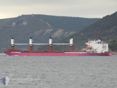
BR GLORY
Bulk Carrier
Current Trip
| Time Travelled | 10 days |
|---|---|
| Remaining Time | --- |
| Distance Travelled | 2037.73 nm |
| Remaining Distance | --- |
| AVG Speed | 11.9 Knots |
| MAX Speed | 17.4 Knots |
| AVG Wind | 13 knots |
| MAX Wind | 31.8 knots |
| MIN Temp | 12.5°C / 54.5°F |
| MAX Temp | 21.5°C / 70.7°F |
| Draught | 0.9 m |
| Position Received | 4 m ago |
Current Position
| Longitude | 28.85957° |
|---|---|
| Latitude | 40.93991° |
| Status | At anchor |
| Speed | |
| Course | 55° |
| Area | Sea of Marmara |
| Station | T-AIS |
| Position Received | 4 m ago |
Info
Information
The current position of BR GLORY is in Sea of Marmara with coordinates 40.93991° / 28.85957° as reported on 2024-05-10 15:14 by AIS to our vessel tracker app. The vessel's current speed is 0 Knots
The vessel BR GLORY (IMO: 8907577, MMSI: 341902000) is a Bulk Carrier that was built in 1990 ( 34 years old ). It's sailing under the flag of [KN] St Kitts Nevis.
In this page you can find informations about the vessels current position, last detected port calls, and current voyage information. If the vessels is not in coverage by AIS you will find the latest position.
The current position of BR GLORY is detected by our AIS receivers and we are not responsible for the reliability of the data. The last position was recorded while the vessel was in Coverage by the Ais receivers of our vessel tracking app.
The current draught of BR GLORY as reported by AIS is 0.9 meters
Weather
| Temperature | 16.1°C / 60.98°F |
|---|---|
| Wind Speed | 20 knots |
| Direction | 43° NE |
| Pressure | 1010.7 hPa |
| Humidity | 70.6 % |
| Cloud Coverage | 98 % |
Featured Company
Last Port Calls
| Port | Arrival | Departure | Time In Port |
|---|---|---|---|
| 2024-04-27 19:42 | 2024-04-30 08:46 | 2 d | |
| 2024-04-22 15:30 | 2024-04-25 07:11 | 2 d | |
| 2024-03-28 00:45 | 2024-04-11 08:02 | 14 d | |
| 2024-03-27 07:31 | 2024-03-27 23:44 | 16 h | |
| 2024-03-15 07:02 | 2024-03-25 14:29 | 10 d | |
| 2024-03-08 15:31 |
Most Visited Ports (Last year)
| Port | Arrivals | |
|---|---|---|
| 5 | ||
| 4 | ||
| 2 | ||
| 1 | ||
| 1 | ||
| 1 |
Last Trips
| Origin | Departure | Destination | Arrival | Distance | |
|---|---|---|---|---|---|
| 2024-04-25 08:11 | 2024-04-27 20:42 | 477.35 nm | |||
| 2024-04-11 11:02 | 2024-04-22 16:30 | 1885.35 nm | |||
| 2024-03-28 02:44 | 2024-03-28 03:45 | 4.47 nm | |||
| 2024-03-25 17:29 | 2024-03-27 10:31 | 5.78 nm | |||
| 2024-03-08 17:31 | 2024-03-15 10:02 | 1208.45 nm |
Events
| Time | Event | Details | Position / Dest | Info |
|---|---|---|---|---|
| 2024-05-10 07:41 | Status Changed | At anchor Default |
40.94489 / 28.85981
RO SUL
|
Speed: Course: 71° |
| 2024-05-10 07:35 | Status Changed | Default At anchor |
40.94479 / 28.85981
RO SUL
|
Speed: Course: 71° |
| 2024-05-09 20:08 | Status Changed | At anchor Default |
40.94424 / 28.86116
RO SUL
|
Speed: Course: 51° |
| 2024-05-09 20:02 | Status Changed | Default At anchor |
40.94436 / 28.86117
RO SUL
|
Speed: Course: 42° |
| 2024-05-09 19:53 | Status Changed | At anchor Default |
40.94424 / 28.86122
RO SUL
|
Speed: Course: 44° |
| 2024-05-09 19:50 | Status Changed | Default At anchor |
40.94433 / 28.86126
RO SUL
|
Speed: Course: 51° |
| 2024-05-09 18:53 | Status Changed | At anchor Default |
40.94437 / 28.86095
RO SUL
|
Speed: Course: 48° |
| 2024-05-09 18:50 | Status Changed | Default At anchor |
40.94428 / 28.86098
RO SUL
|
Speed: Course: 42° |
| 2024-05-09 03:02 | Status Changed | At anchor Default |
40.94510 / 28.86113
RO SUL
|
Speed: Course: 50° |
| 2024-05-09 02:56 | Status Changed | Default At anchor |
40.94495 / 28.86114
RO SUL
|
Speed: Course: 50° |