
THEODELA C
Tanker
Current Trip
| Time Travelled | 19 h, 29 mins |
|---|---|
| Remaining Time | 2 days |
| Distance Travelled | 104.49 морская миля |
| Remaining Distance | 223.91 морская миля |
| AVG Speed | 5.5 Узлы |
| MAX Speed | 7.7 Узлы |
| AVG Wind | 5 knots |
| MAX Wind | 12.3 knots |
| MIN Temp | 5.6°C / 42.08°F |
| MAX Temp | 12.1°C / 53.78°F |
| Осадка | 2.4 м |
| Позиция Получена | Сейчас |
Current Position
| Долгота | 6.68146° |
|---|---|
| Широта | 51.48623° |
| Статус | Under way using engine |
| Скорость | 5 Узлы |
| Курс | 208.5° |
| Район | North Sea |
| Станция | T-AIS |
| Позиция Получена | Сейчас |
Info
Information
The current position of THEODELA C is in North Sea with coordinates 51.48623° / 6.68146° as reported on 2024-04-27 09:54 by AIS to our vessel tracker app. The vessel's current speed is 5 Узлы and is heading at the port of KARLSRUHE. The estimated time of arrival as calculated by MyShipTracking vessel tracking app is 2024-04-29 11:57 LT
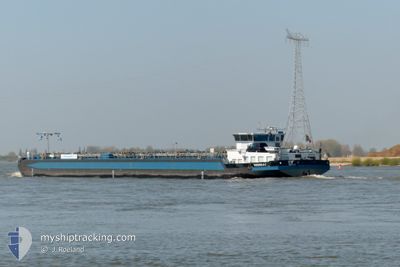
The vessel THEODELA C (MMSI: 205420690) is a Tanker It's sailing under the flag of [BE] Belgium.
In this page you can find informations about the vessels current position, last detected port calls, and current voyage information. If the vessels is not in coverage by AIS you will find the latest position.
The current position of THEODELA C is detected by our AIS receivers and we are not responsible for the reliability of the data. The last position was recorded while the vessel was in Coverage by the Ais receivers of our vessel tracking app.
The current draught of THEODELA C as reported by AIS is 2.4 meters
Weather
| Temperature | 10.8°C / 51.44°F |
|---|---|
| Wind Speed | 8 knots |
| Direction | 146° SE |
| Pressure | 1006.4 hPa |
| Humidity | 89.8 % |
| Cloud Coverage | 100 % |
Featured Company
Last Port Calls
| Port | Arrival | Departure | Time In Port |
|---|---|---|---|
| 2024-04-21 11:49 | 2024-04-26 14:25 | 5 d | |
| 2024-04-21 11:05 | 2024-04-21 11:36 | 31 m | |
| 2024-04-18 15:45 | 2024-04-19 15:35 | 23 h | |
| 2024-04-16 07:28 | 2024-04-16 08:23 | 54 m | |
| 2024-04-15 19:16 | 2024-04-16 04:25 | 9 h | |
| 2024-04-15 08:09 | 2024-04-15 09:13 | 1 h | |
| 2024-04-14 18:40 | 2024-04-15 04:09 | 9 h | |
| 2024-04-14 16:37 | 2024-04-14 16:47 | 10 m | |
| 2024-04-08 18:17 | 2024-04-14 12:01 | 5 d | |
| 2024-04-08 17:34 | 2024-04-08 18:05 | 31 m |
Last Trips
| Origin | Departure | Destination | Arrival | Distance | |
|---|---|---|---|---|---|
| 2024-04-21 13:36 | 2024-04-21 13:49 | 2.27 морская миля | |||
| 2024-04-19 17:35 | 2024-04-21 13:05 | 317.16 морская миля | |||
| 2024-04-16 10:23 | 2024-04-18 17:45 | 188.50 морская миля | |||
| 2024-04-16 06:25 | 2024-04-16 09:28 | 14.17 морская миля | |||
| 2024-04-15 11:13 | 2024-04-15 21:16 | 47.94 морская миля | |||
| 2024-04-15 06:09 | 2024-04-15 10:09 | 21.38 морская миля | |||
| 2024-04-14 18:47 | 2024-04-14 20:40 | 9.36 морская миля | |||
| 2024-04-14 14:01 | 2024-04-14 18:37 | 31.92 морская миля | |||
| 2024-04-08 20:05 | 2024-04-08 20:17 | 2.03 морская миля | |||
| 2024-04-08 09:09 | 2024-04-08 19:34 | 104.30 морская миля |
Events
| Время | Событие | Детали | Позиция / Направление | Информация |
|---|---|---|---|---|
| 2024-04-27 07:44 | Статус изменился | Under way using engine Default |
51.56583 / 6.61583
KARLSRUHE
|
Скорость: 4 kn Курс: -1° |
| 2024-04-27 07:19 | Статус изменился | Default Under way using engine |
51.59167 / 6.59667
KARLSRUHE
|
Скорость: 5.3 kn Курс: 168.1° |
| 2024-04-27 07:14 | Статус изменился | Under way using engine Default |
51.59926 / 6.59557
KARLSRUHE
|
Скорость: 5 kn Курс: 160° |
| 2024-04-27 07:10 | В покрытии |
51.59926 / 6.59557
North Sea
KARLSRUHE
|
Скорость: 5.3 kn Курс: 171° |
|
| 2024-04-27 03:34 | Статус изменился | Default Under way using engine |
51.76167 / 6.33167
KARLSRUHE
|
Скорость: 4.1 kn Курс: 158.8° |
| 2024-04-27 03:28 | Вне покрытия |
51.76870 / 6.32804
North Sea
KARLSRUHE
|
Скорость: 4.1 kn Курс: 158.8° |
|
| 2024-04-27 03:13 | Статус изменился | Under way using engine Default |
51.78896 / 6.31971
KARLSRUHE
|
Скорость: 5 kn Курс: 136° |
| 2024-04-27 02:58 | Статус изменился | Default Under way using engine |
51.80500 / 6.29833
KARLSRUHE
|
Скорость: 5 kn Курс: 119.1° |
| 2024-04-26 20:19 | Начало движения | 0.88 nm, North East of TIEL |
51.89950 / 5.45511
KARLSRUHE
|
Скорость: 3.4 kn Курс: 158.5° |
| 2024-04-26 20:17 | Статус изменился | Under way using engine Moored |
51.90085 / 5.45421
KARLSRUHE
|
Скорость: 0.2 kn Курс: 511° |