
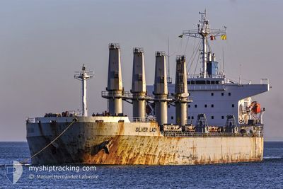
M/V SILVER LADY
Bulk Carrier
Current Trip
| Time Travelled | 3 days |
|---|---|
| Remaining Time | 3 h, 41 mins |
| Distance Travelled | 1148.90 nm |
| Remaining Distance | 52.91 nm |
| AVG Speed | 12.5 Noeuds |
| MAX Speed | 14.3 Noeuds |
| AVG Wind | 8.9 knots |
| MAX Wind | 18.8 knots |
| MIN Temp | 7.7°C / 45.86°F |
| MAX Temp | 13.5°C / 56.3°F |
| Tirant d eau | 6.3 m |
| Position reçue | Maintenant |
Current Position
| Longitude | --- |
|---|---|
| Latitude | --- |
| Etat | Under way using engine |
| Vitesse | 13.6 Noeuds |
| Parcours | 57° |
| Zone | Skaggerak |
| Station | T-AIS |
| Position reçue | Maintenant |
Info
Information
The current position of M/V SILVER LADY is in Skaggerak with coordinates 57.54423° / 9.49677° as reported on 2024-12-27 13:07 by AIS to our vessel tracker app. The vessel's current speed is 13.6 Noeuds and is heading at the port of SKAGEN. The estimated time of arrival as calculated by MyShipTracking vessel tracking app is 2024-12-27 16:49 LT
The vessel M/V SILVER LADY (IMO: 9279367, MMSI: 249008000) is a Bulk Carrier that was built in 2003 ( 21 Age ). It's sailing under the flag of [MT] Malta.
In this page you can find informations about the vessels current position, last detected port calls, and current voyage information. If the vessels is not in coverage by AIS you will find the latest position.
The current position of M/V SILVER LADY is detected by our AIS receivers and we are not responsible for the reliability of the data. The last position was recorded while the vessel was in Coverage by the Ais receivers of our vessel tracking app.
The current draught of M/V SILVER LADY as reported by AIS is 6.3 meters
Weather
| Temperature | --- |
|---|---|
| Wind Speed | --- |
| Direction | --- |
| Pressure | --- |
| Humidity | --- |
| Cloud Coverage | --- |
Featured Company
Last Port Calls
| Port | Arrival | Departure | Time In Port |
|---|---|---|---|
| 2024-12-14 12:53 | 2024-12-23 14:09 | 9 d | |
| 2024-11-09 17:35 | 2024-11-16 18:51 | 7 d | |
| 2024-10-31 21:11 | 2024-11-02 21:14 | 2 d | |
| 2024-10-13 21:46 | 2024-10-19 16:43 | 5 d | |
| 2024-10-09 07:49 | 2024-10-09 17:40 | 9 h |
Most Visited Ports (Last year)
| Port | Arrivals | |
|---|---|---|
| 3 | ||
| 2 | ||
| 1 | ||
| 1 | ||
| 1 | ||
| 1 |
Last Trips
| Origin | Departure | Destination | Arrival | Distance | |
|---|---|---|---|---|---|
| 2024-11-16 20:51 | 2024-12-14 13:53 | 6678.23 nm | |||
| 2024-11-02 23:14 | 2024-11-09 19:35 | 393.83 nm | |||
| 2024-10-19 19:43 | 2024-10-31 23:11 | 3898.90 nm | |||
| 2024-09-15 13:59 | 2024-10-14 00:46 | 8337.25 nm | |||
| 2024-09-15 13:59 | 2024-10-09 09:49 | 6952.56 nm |
Events
| Heure | Evenement | Détails | Position/ Destination | Info |
|---|---|---|---|---|
| 2024-12-27 11:36 | Changement d'ETA | 2024/12/27 20:00 2024/12/27 22:00 |
57.36368 / 8.96240
DK SKA
|
Vitesse: 13.4 kn Parcours: 57° |
| 2024-12-27 10:13 | Changement de zone | Danish part of the Skaggerak Danish part of the North Sea |
57.19612 / 8.48933
Skaggerak
DK SKA
|
Vitesse: 13.7 kn Parcours: 49° |
| 2024-12-27 00:46 | Etat Changé | Under way using engine Default |
55.62578 / 6.27323
DK SKA
|
Vitesse: 12.8 kn Parcours: 32° |
| 2024-12-27 00:42 | Etat Changé | Default Under way using engine |
55.61180 / 6.25723
DK SKA
|
Vitesse: 12.8 kn Parcours: 32° |
| 2024-12-27 00:36 | Etat Changé | Under way using engine Default |
55.59392 / 6.23695
DK SKA
|
Vitesse: 12.7 kn Parcours: 33° |
| 2024-12-27 00:30 | Etat Changé | Default Under way using engine |
55.57860 / 6.21930
DK SKA
|
Vitesse: 12.7 kn Parcours: 33° |
| 2024-12-26 23:53 | Detecté en mer | Danish part of the North Sea |
55.46738 / 6.08910
North Sea
DK SKA
|
Vitesse: 12.8 kn Parcours: 36° |
| 2024-12-26 23:46 | Etat Changé | Under way using engine Default |
55.44837 / 6.06410
DK SKA
|
Vitesse: 12.7 kn Parcours: 37° |
| 2024-12-26 23:32 | Etat Changé | Default Under way using engine |
55.40802 / 6.01150
DK SKA
|
Vitesse: 12.7 kn Parcours: 36° |
| 2024-12-26 23:02 | Etat Changé | Under way using engine Default |
55.32167 / 5.90353
DK SKA
|
Vitesse: 13.1 kn Parcours: 35° |