
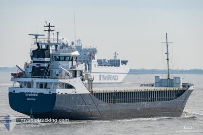
SYDBORG
General Cargo
Current Trip
| Time Travelled | 5 days |
|---|---|
| Remaining Time | 1 day |
| Distance Travelled | 717.78 nm |
| Remaining Distance | 404.92 nm |
| AVG Speed | 9.5 Knots |
| MAX Speed | 11.6 Knots |
| AVG Wind | 7.6 knots |
| MAX Wind | 18.9 knots |
| MIN Temp | 3.5°C / 38.3°F |
| MAX Temp | 11.2°C / 52.16°F |
| Dybgang | 6.2 m |
| Position Modtaget | Nu |
Current Position
| Longitude | 12.22045° |
|---|---|
| Latitude | 54.55342° |
| Status | Under way using engine |
| Fart | 9.6 Knots |
| Kurs | 197.7° |
| Område | Baltic Sea |
| Station | T-AIS |
| Position Modtaget | Nu |
Info
Information
The current position of SYDBORG is in Baltic Sea with coordinates 54.55342° / 12.22045° as reported on 2024-05-05 23:50 by AIS to our vessel tracker app. The vessel's current speed is 9.6 Knots and is heading at the port of AMSTERDAM. The estimated time of arrival as calculated by MyShipTracking vessel tracking app is 2024-05-07 18:21 LT
The vessel SYDBORG (IMO: 9196204, MMSI: 244901000) is a General Cargo that was built in 2000 ( 24 år gamle ). It's sailing under the flag of [NL] Netherlands.
In this page you can find informations about the vessels current position, last detected port calls, and current voyage information. If the vessels is not in coverage by AIS you will find the latest position.
The current position of SYDBORG is detected by our AIS receivers and we are not responsible for the reliability of the data. The last position was recorded while the vessel was in Coverage by the Ais receivers of our vessel tracking app.
The current draught of SYDBORG as reported by AIS is 6.2 meters
Weather
| Temperature | 9.7°C / 49.46°F |
|---|---|
| Wind Speed | 18 knots |
| Direction | 240° WSW |
| Pressure | 1004.8 hPa |
| Humidity | 92.8 % |
| Cloud Coverage | 88 % |
Featured Company
Last Port Calls
| Port | Arrival | Departure | Time In Port |
|---|---|---|---|
| 2024-04-29 12:44 | 2024-04-30 16:00 | 1 d | |
| 2024-04-24 23:32 | 2024-04-25 00:57 | 1 h | |
| 2024-04-23 21:33 | 2024-04-24 22:03 | 1 d | |
| 2024-04-23 12:29 | 2024-04-23 14:24 | 1 h | |
| 2024-04-20 22:23 | 2024-04-23 11:30 | 2 d | |
| 2024-04-20 18:59 | 2024-04-20 22:02 | 3 h | |
| 2024-04-13 02:59 | 2024-04-16 09:18 | 3 d | |
| 2024-04-08 10:36 | 2024-04-09 16:12 | 1 d | |
| 2024-04-06 10:46 | 2024-04-08 10:16 | 1 d | |
| 2024-03-31 17:09 | 2024-04-02 17:44 | 2 d |
Last Trips
| Origin | Departure | Destination | Arrival | Distance | |
|---|---|---|---|---|---|
| 2024-04-25 02:57 | 2024-04-29 15:44 | 984.08 nm | |||
| 2024-04-25 00:03 | 2024-04-25 01:32 | 8.48 nm | |||
| 2024-04-23 16:24 | 2024-04-23 23:33 | 37.23 nm | |||
| 2024-04-23 13:30 | 2024-04-23 14:29 | 3.86 nm | |||
| 2024-04-21 00:02 | 2024-04-21 00:23 | 0.93 nm | |||
| 2024-04-16 12:18 | 2024-04-20 20:59 | 896.76 nm | |||
| 2024-04-09 18:12 | 2024-04-13 05:59 | 782.08 nm | |||
| 2024-04-08 12:16 | 2024-04-08 12:36 | 0.07 nm | |||
| 2024-04-02 18:44 | 2024-04-06 12:46 | 309.01 nm | |||
| 2024-03-28 18:34 | 2024-03-31 18:09 | 737.40 nm |
Events
| Tid | Hændelsen | Detaljer | Position / Dest | Info |
|---|---|---|---|---|
| 2024-05-05 22:44 | Fundet i havområde | Danish part of the Baltic Sea |
54.67327 / 12.41986
Baltic Sea
FIKTK>NLAMS
|
Fart: 9.6 kn Kurs: 237.1° |
| 2024-05-05 22:29 | Fundet i havområde | German part of the Baltic Sea |
54.69526 / 12.47737
Baltic Sea
FIKTK>NLAMS
|
Fart: 9.7 kn Kurs: 237.2° |
| 2024-05-05 20:46 | Fundet i havområde | Danish part of the Baltic Sea |
54.82308 / 12.90162
Baltic Sea
FIKTK>NLAMS
|
Fart: 9.9 kn Kurs: 250.8° |
| 2024-05-05 19:21 | Dybgangen er ændret | 6.2 6.1 |
54.90277 / 13.28794
FIKTK>NLAMS
|
Fart: 9.7 kn Kurs: 250.5° |
| 2024-05-05 17:32 | Fundet i havområde | German part of the Baltic Sea |
55.01472 / 13.78479
Baltic Sea
FIKTK>NLAMS
|
Fart: 10.3 kn Kurs: 249.9° |
| 2024-05-05 13:11 | Fundet i havområde | Swedish part of the Baltic Sea |
55.49509 / 14.73998
Baltic Sea
FIKTK>NLAMS
|
Fart: 10.4 kn Kurs: 241.2° |
| 2024-05-05 11:22 | Ændre havområde | Danish part of the Kattegat Swedish part of the Baltic Sea |
55.64993 / 15.21828
Kattegat
FIKTK>NLAMS
|
Fart: 10.5 kn Kurs: 241.1° |
| 2024-05-05 06:55 | Status er ændret | Under way using engine Default |
56.02751 / 16.41842
FIKTK>NLAMS
|
Fart: 10.3 kn Kurs: 238° |
| 2024-05-05 06:52 | Status er ændret | Default Under way using engine |
56.03146 / 16.43021
FIKTK>NLAMS
|
Fart: 10.3 kn Kurs: 239.9° |
| 2024-05-05 05:53 | Status er ændret | Under way using engine Default |
56.12033 / 16.69058
FIKTK>NLAMS
|
Fart: 10.2 kn Kurs: 233° |