
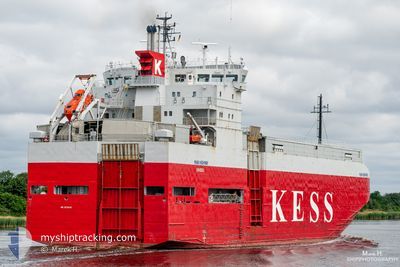
ERK IZMIR
Vehicles Carrier
Current Trip
| Time Travelled | 2 days |
|---|---|
| Remaining Time | 6 h, 35 mins |
| Distance Travelled | 439.13 nm |
| Remaining Distance | 111.41 nm |
| AVG Speed | 11.4 Knots |
| MAX Speed | 13 Knots |
| AVG Wind | 17 knots |
| MAX Wind | 24 knots |
| MIN Temp | 7.6°C / 45.68°F |
| MAX Temp | 11.3°C / 52.34°F |
| Dybgang | 4.8 m |
| Position Modtaget | 2 d siden |
Current Position
| Longitude | --- |
|---|---|
| Latitude | --- |
| Status | Under way using engine |
| Fart | 12.6 Knots |
| Kurs | 239.4° |
| Område | Bay of Biscay |
| Station | T-AIS |
| Position Modtaget | 2 d siden |
Info
Information
The current position of ERK IZMIR is in Bay of Biscay with coordinates 46.74954° / -3.31614° as reported on 2026-01-02 18:56 by AIS to our vessel tracker app. The vessel's current speed is 12.6 Knots and is heading at the port of VIGO. The estimated time of arrival as calculated by MyShipTracking vessel tracking app is 2026-01-05 10:35 LT
The vessel ERK IZMIR (IMO: 9179983, MMSI: 352002302) is a Vehicles Carrier that was built in 1998 ( 28 år gamle ). It's sailing under the flag of [PA] Panama.
In this page you can find informations about the vessels current position, last detected port calls, and current voyage information. If the vessels is not in coverage by AIS you will find the latest position.
The current position of ERK IZMIR is detected by our AIS receivers and we are not responsible for the reliability of the data. The last position was recorded while the vessel was in Coverage by the Ais receivers of our vessel tracking app.
The current draught of ERK IZMIR as reported by AIS is 4.8 meters
Weather
| Temperature | 11.3°C / 52.34°F |
|---|---|
| Wind Speed | 23 knots |
| Direction | 30° NNE |
| Pressure | 1016.4 hPa |
| Humidity | 54.7 % |
| Cloud Coverage | 85 % |
Featured Company
Last Port Calls
| Port | Arrival | Departure | Time In Port |
|---|---|---|---|
| 2025-12-30 09:36 | 2026-01-02 15:09 | 3 d | |
| 2025-12-26 07:49 | 2025-12-26 20:28 | 12 h | |
| 2025-12-22 10:14 | 2025-12-23 23:22 | 1 d | |
| 2025-12-20 10:19 | 2025-12-20 21:02 | 10 h | |
| 2025-12-19 07:34 | 2025-12-19 16:38 | 9 h | |
| 2025-12-15 19:44 | 2025-12-16 05:47 | 10 h | |
| 2025-12-15 00:03 | 2025-12-15 11:02 | 10 h | |
| 2025-12-09 10:59 | 2025-12-09 21:18 | 10 h | |
| 2025-12-07 08:56 | 2025-12-07 19:48 | 10 h | |
| 2025-12-05 04:50 | 2025-12-05 23:27 | 18 h |
Most Visited Ports (Last year)
| Port | Arrivals | |
|---|---|---|
| 21 | ||
| 11 | ||
| 10 | ||
| 5 | ||
| 4 | ||
| 4 |
Last Trips
| Origin | Departure | Destination | Arrival | Distance | |
|---|---|---|---|---|---|
| 2025-12-26 20:28 | 2025-12-30 09:36 | 993.22 nm | |||
| 2025-12-23 23:22 | 2025-12-26 07:49 | 629.05 nm | |||
| 2025-12-20 21:02 | 2025-12-22 10:14 | 387.89 nm | |||
| 2025-12-19 16:38 | 2025-12-20 10:19 | 203.17 nm | |||
| 2025-12-16 05:47 | 2025-12-19 07:34 | 888.82 nm | |||
| 2025-12-15 11:02 | 2025-12-15 19:44 | 54.66 nm | |||
| 2025-12-09 21:18 | 2025-12-15 00:03 | 854.85 nm | |||
| 2025-12-07 19:48 | 2025-12-09 10:59 | 464.72 nm | |||
| 2025-12-05 23:27 | 2025-12-07 08:56 | 259.21 nm | |||
| 2025-11-25 01:08 | 2025-12-05 04:50 | 2801.29 nm |
Events
| Tid | Hændelsen | Detaljer | Position / Dest | Info |
|---|---|---|---|---|
| 2026-01-03 19:52 | START Sejllads |
46.33833 / -3.93333
ESVGO
|
Fart: 4 kn Kurs: -1° |
|
| 2026-01-03 10:18 | STOP Sejllads |
46.50167 / -3.81167
ESVGO
|
Fart: Kurs: -1° |
|
| 2026-01-02 18:58 | Status er ændret | Default Under way using engine |
46.74628 / -3.32408
ESVGO
|
Fart: 12.6 kn Kurs: 239.4° |
| 2026-01-02 18:56 | Udenfor Dækning |
46.74954 / -3.31614
Bay of Biscay
ESVGO
|
Fart: 12.6 kn Kurs: 239.4° |
|
| 2026-01-02 16:02 | ETA er ændret | 2026/01/05 11:00 2026/01/05 12:00 |
47.04664 / -2.54227
ESVGO
|
Fart: 12.3 kn Kurs: 245.4° |
| 2026-01-02 15:28 | ETA er ændret | 2026/01/05 12:00 2026/01/05 07:00 |
47.10880 / -2.39832
ESVGO
|
Fart: 12.4 kn Kurs: 227.8° |
| 2026-01-02 14:10 | START Sejllads | 0.84 nm, South West of MONTOIR |
47.28891 / -2.16280
ESVGO
|
Fart: 3.4 kn Kurs: 232° |
| 2026-01-02 14:09 | Afsejlet fra sidste havn |
|
47.28932 / -2.16229
ESVGO
|
Fart: 1.7 kn Kurs: 231° |
| 2026-01-02 13:51 | Status er ændret | Under way using engine Moored |
47.29102 / -2.16483
[FR] MONTOIR
|
Fart: Kurs: 50° |
| 2026-01-02 13:49 | Status er ændret | Moored Default |
47.29102 / -2.16483
[FR] MONTOIR
|
Fart: Kurs: 50° |