
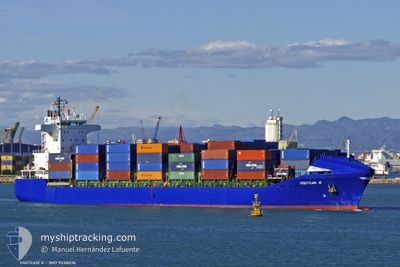
ONUR G A
Container Ship
Current Trip
GE PTI
| Time Travelled | 2 h, 57 mins |
|---|---|
| Remaining Time | --- |
| Distance Travelled | 12.83 nm |
| Remaining Distance | --- |
| AVG Speed | 13.6 Knots |
| MAX Speed | 14.4 Knots |
| AVG Wind | 6.1 knots |
| MAX Wind | 7.4 knots |
| MIN Temp | 8.2°C / 46.76°F |
| MAX Temp | 9.7°C / 49.46°F |
| Draught | 8.6 m |
| Position Received | 3 d ago |
Current Position
| Longitude | --- |
|---|---|
| Latitude | --- |
| Status | Under way using engine |
| Speed | 14.4 Knots |
| Course | 73.9° |
| Area | Black Sea |
| Station | T-AIS |
| Position Received | 3 d ago |
Info
Information
The current position of ONUR G A is in Black Sea with coordinates 41.38829° / 29.78547° as reported on 2025-02-14 04:37 by AIS to our vessel tracker app. The vessel's current speed is 14.4 Knots
The vessel ONUR G A (IMO: 9238076, MMSI: 215424000) is a Container Ship that was built in 2001 ( 24 years old ). It's sailing under the flag of [MT] Malta.
In this page you can find informations about the vessels current position, last detected port calls, and current voyage information. If the vessels is not in coverage by AIS you will find the latest position.
The current position of ONUR G A is detected by our AIS receivers and we are not responsible for the reliability of the data. The last position was recorded while the vessel was in Coverage by the Ais receivers of our vessel tracking app.
The current draught of ONUR G A as reported by AIS is 8.6 meters
Weather
| Temperature | 9.6°C / 49.28°F |
|---|---|
| Wind Speed | 8 knots |
| Direction | 350° N |
| Pressure | 1016.4 hPa |
| Humidity | 81 % |
| Cloud Coverage | 100 % |
Featured Company
Last Port Calls
| Port | Arrival | Departure | Time In Port |
|---|---|---|---|
| 2025-02-16 11:57 | 2025-02-17 20:33 | 1 d | |
| 2025-02-12 15:24 | 2025-02-13 00:29 | 9 h | |
| 2025-02-12 07:36 | 2025-02-12 15:03 | 7 h | |
| 2025-02-08 21:13 | 2025-02-11 01:16 | 2 d | |
| 2025-02-04 22:06 | 2025-02-05 07:09 | 9 h | |
| 2025-02-01 13:53 | 2025-02-02 09:17 | 19 h | |
| 2025-01-30 14:41 | 2025-01-31 20:13 | 1 d | |
| 2025-01-27 10:50 | 2025-01-27 23:29 | 12 h | |
| 2025-01-23 14:01 | 2025-01-25 04:45 | 1 d | |
| 2025-01-13 12:21 | 2025-01-14 17:21 | 1 d |
Last Trips
| Origin | Departure | Destination | Arrival | Distance | |
|---|---|---|---|---|---|
| 2025-02-13 03:29 | 2025-02-16 15:57 | 665.68 nm | |||
| 2025-02-12 18:03 | 2025-02-12 18:24 | 0.60 nm | |||
| 2025-02-11 03:16 | 2025-02-12 10:36 | 371.99 nm | |||
| 2025-02-05 10:09 | 2025-02-08 23:13 | 507.82 nm | |||
| 2025-02-02 12:17 | 2025-02-05 01:06 | 447.13 nm | |||
| 2025-02-01 00:13 | 2025-02-01 16:53 | 246.60 nm | |||
| 2025-01-28 02:29 | 2025-01-30 18:41 | 637.61 nm | |||
| 2025-01-25 06:45 | 2025-01-27 13:50 | 369.16 nm | |||
| 2025-01-14 20:21 | 2025-01-23 16:01 | 975.57 nm | |||
| 2025-01-12 22:12 | 2025-01-13 15:21 | 246.67 nm |
Events
| Time | Event | Details | Position / Dest | Info |
|---|---|---|---|---|
| 2025-02-17 20:33 | PORT DEPARTURE |
|
42.16375 / 41.64195
GE PTI
|
Speed: 3.5 kn Course: 262° |
| 2025-02-17 20:21 | START Moving |
42.15435 / 41.65463
[GE] POTI
|
Speed: 3.5 kn Course: 262° |
|
| 2025-02-16 12:29 | STOP Moving |
42.15389 / 41.66434
[GE] POTI
|
Speed: 0.2 kn Course: 3° |
|
| 2025-02-16 11:57 | PORT ARRIVAL |
|
42.15873 / 41.64789
[GE] POTI
|
Speed: 4.3 kn Course: 128° |
| 2025-02-16 11:37 | START Moving | 1.39 nm, North West of POTI |
42.16669 / 41.62124
GE PTI
|
Speed: 3.2 kn Course: 81° |
| 2025-02-15 18:01 | STOP Moving | 1.7 nm, West of POTI |
42.16204 / 41.61191
GE PTI
|
Speed: 0.3 kn Course: 124° |
| 2025-02-14 04:38 | Status Changed | Default Under way using engine |
41.38920 / 29.78957
GE PTI
|
Speed: 14.4 kn Course: 73.9° |
| 2025-02-14 04:37 | OUT of Coverage |
41.38829 / 29.78547
Black Sea
GE PTI
|
Speed: 14.4 kn Course: 73.9° |
|
| 2025-02-14 02:25 | Change Sea Area | Turkish part of the Black Sea Turkish part of the Sea of Marmara |
41.22915 / 29.14718
Black Sea
GE PTI
|
Speed: 12.6 kn Course: 32.3° |
| 2025-02-13 11:20 | START Moving | 18.18 nm, South of YESILKOY |
40.65218 / 28.82079
GE PTI
|
Speed: 3.1 kn Course: 1° |