
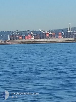
WAN HAI A03
Cargo
Current Trip
| Time Travelled | 1 day |
|---|---|
| Remaining Time | --- |
| Distance Travelled | 444.31 nm |
| Remaining Distance | --- |
| AVG Speed | 15.7 Knots |
| MAX Speed | 21.1 Knots |
| AVG Wind | 9.6 knots |
| MAX Wind | 15 knots |
| MIN Temp | 24.9°C / 76.82°F |
| MAX Temp | 28.3°C / 82.94°F |
| Draught | 15.3 m |
| Position Received | 1 d ago |
Current Position
| Longitude | --- |
|---|---|
| Latitude | --- |
| Status | Under way using engine |
| Speed | 17.6 Knots |
| Course | 302.5° |
| Area | Malacca Strait |
| Station | T-AIS |
| Position Received | 1 d ago |
Info
Information
The current position of WAN HAI A03 is in Malacca Strait with coordinates 1.24906° / 103.38973° as reported on 2025-02-17 19:52 by AIS to our vessel tracker app. The vessel's current speed is 17.6 Knots and is heading at the port of NEW YORK. The estimated time of arrival as calculated by MyShipTracking vessel tracking app is 2025-03-17 22:00 LT
The vessel WAN HAI A03 (IMO: 9935105, MMSI: 563194900) is a Cargo It's sailing under the flag of [SG] Singapore.
In this page you can find informations about the vessels current position, last detected port calls, and current voyage information. If the vessels is not in coverage by AIS you will find the latest position.
The current position of WAN HAI A03 is detected by our AIS receivers and we are not responsible for the reliability of the data. The last position was recorded while the vessel was in Coverage by the Ais receivers of our vessel tracking app.
The current draught of WAN HAI A03 as reported by AIS is 15.3 meters
Weather
| Temperature | 27.9°C / 82.22°F |
|---|---|
| Wind Speed | 4 knots |
| Direction | 315° NW |
| Pressure | 1010.5 hPa |
| Humidity | 69.2 % |
| Cloud Coverage | 34 % |
Featured Company
Last Port Calls
| Port | Arrival | Departure | Time In Port |
|---|---|---|---|
| 2025-02-16 15:06 | 2025-02-17 17:45 | 1 d | |
| 2025-02-15 16:01 | 2025-02-16 14:32 | 22 h | |
| 2025-02-11 19:10 | 2025-02-12 10:33 | 15 h | |
| 2025-02-08 10:37 | 2025-02-09 12:41 | 1 d | |
| 2025-02-06 22:37 | 2025-02-07 09:37 | 10 h | |
| 2025-02-03 21:57 | 2025-02-04 12:20 | 14 h | |
| 2025-01-13 12:09 | 2025-01-14 23:58 | 1 d | |
| 2024-12-30 11:13 | 2025-01-07 12:31 | 8 d | |
| 2024-12-04 21:13 | 2024-12-05 09:46 | 12 h | |
| 2024-12-02 12:24 | 2024-12-03 15:12 | 1 d |
Last Trips
| Origin | Departure | Destination | Arrival | Distance | |
|---|---|---|---|---|---|
| 2025-02-16 22:32 | 2025-02-16 23:06 | 2.15 nm | |||
| 2025-02-12 17:33 | 2025-02-16 00:01 | 703.08 nm | |||
| 2025-02-09 20:41 | 2025-02-12 02:10 | 1003.62 nm | |||
| 2025-02-07 17:37 | 2025-02-08 18:37 | 85.33 nm | |||
| 2025-02-04 20:20 | 2025-02-07 06:37 | 460.95 nm | |||
| 2025-01-14 15:58 | 2025-02-04 05:57 | 6640.83 nm | |||
| 2025-01-07 04:31 | 2025-01-13 04:09 | 830.49 nm | |||
| 2024-12-05 17:46 | 2024-12-30 03:13 | 7094.88 nm | |||
| 2024-12-03 23:12 | 2024-12-05 05:13 | 484.76 nm | |||
| 2024-11-28 13:04 | 2024-12-02 20:24 | 1084.66 nm |
Events
| Time | Event | Details | Position / Dest | Info |
|---|---|---|---|---|
| 2025-02-17 19:57 | Status Changed | Default Under way using engine |
1.26376 / 103.36940
US NYC
|
Speed: 17.6 kn Course: 302.5° |
| 2025-02-17 19:52 | OUT of Coverage |
1.24906 / 103.38973
Malacca Strait
US NYC
|
Speed: 17.6 kn Course: 302.5° |
|
| 2025-02-17 19:49 | Change Sea Area | Malaysian part of the Malacca Strait Indonesian part of the Malacca Strait |
1.24114 / 103.40150
Malacca Strait
US NYC
|
Speed: 17.5 kn Course: 302.8° |
| 2025-02-17 19:44 | Change Sea Area | Indonesian part of the Malacca Strait Malaysian part of the Malacca Strait |
1.22887 / 103.42315
Malacca Strait
US NYC
|
Speed: 17.4 kn Course: 294.3° |
| 2025-02-17 19:37 | Change Sea Area | Malaysian part of the Malacca Strait Malaysian part of the Singapore Strait |
1.21751 / 103.45825
Malacca Strait
US NYC
|
Speed: 16.7 kn Course: 285.7° |
| 2025-02-17 19:06 | Change Sea Area | Malaysian part of the Singapore Strait Indonesian part of the Singapore Strait |
1.19271 / 103.58483
Singapore Strait
US NYC
|
Speed: 13.9 kn Course: 280° |
| 2025-02-17 18:43 | Change Sea Area | Indonesian part of the Singapore Strait Singaporean part of the Singapore Strait |
1.19747 / 103.64782
Singapore Strait
US NYC
|
Speed: 5.2 kn Course: 231.7° |
| 2025-02-17 17:45 | PORT DEPARTURE |
|
1.26691 / 103.76368
US NYC
|
Speed: 7.4 kn Course: 280° |
| 2025-02-17 17:40 | START Moving |
1.26563 / 103.77227
[SG] SINGAPORE
|
Speed: 3.1 kn Course: 276° |
|
| 2025-02-17 17:33 | Destination Changed | US NYC SGSIN EBGA |
1.26771 / 103.77461
[SG] SINGAPORE
|
Speed: 1.2 kn Course: 234° |