
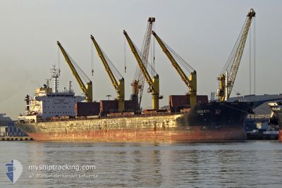
VESLETS
Bulk Carrier
Current Trip
RULED
| Time Travelled | 20 h, 57 mins |
|---|---|
| Remaining Time | --- |
| Distance Travelled | 151.99 nm |
| Remaining Distance | --- |
| AVG Speed | 8.3 Knots |
| MAX Speed | 11.3 Knots |
| AVG Wind | 8.5 knots |
| MAX Wind | 12 knots |
| MIN Temp | -0.1°C / 31.82°F |
| MAX Temp | 4.3°C / 39.74°F |
| Draught | 8 m |
| Position Received | 1 m ago |
Current Position
| Longitude | --- |
|---|---|
| Latitude | --- |
| Status | Under way using engine |
| Speed | 11.1 Knots |
| Course | 256.7° |
| Area | Gulf of Finland |
| Station | T-AIS |
| Position Received | 1 m ago |
Info
Information
The current position of VESLETS is in Gulf of Finland with coordinates 59.82330° / 24.66853° as reported on 2026-03-12 03:01 by AIS to our vessel tracker app. The vessel's current speed is 11.1 Knots
The vessel VESLETS (IMO: 9621883, MMSI: 229012000) is a Bulk Carrier that was built in 2012 ( 14 years old ). It's sailing under the flag of [MT] Malta.
In this page you can find informations about the vessels current position, last detected port calls, and current voyage information. If the vessels is not in coverage by AIS you will find the latest position.
The current position of VESLETS is detected by our AIS receivers and we are not responsible for the reliability of the data. The last position was recorded while the vessel was in Coverage by the Ais receivers of our vessel tracking app.
The current draught of VESLETS as reported by AIS is 8 meters
Weather
| Temperature | 2.6°C / 36.68°F |
|---|---|
| Wind Speed | 12 knots |
| Direction | 191° S |
| Pressure | 1009.8 hPa |
| Humidity | 93.7 % |
| Cloud Coverage | 89 % |
Featured Company
Last Port Calls
| Port | Arrival | Departure | Time In Port |
|---|---|---|---|
| 2026-03-06 16:58 | 2026-03-11 09:05 | 4 d | |
| 2026-02-18 23:04 | 2026-02-26 22:22 | 7 d | |
| 2026-02-09 08:59 | 2026-02-11 10:47 | 2 d | |
| 2026-01-30 19:07 | 2026-02-04 23:07 | 5 d | |
| 2026-01-16 16:13 | 2026-01-22 19:19 | 6 d |
Last Trips
| Origin | Departure | Destination | Arrival | Distance | |
|---|---|---|---|---|---|
| 2026-02-26 22:22 | 2026-03-06 16:58 | 1379.83 nm | |||
| 2026-02-11 10:47 | 2026-02-18 23:04 | 1439.52 nm | |||
| 2026-02-04 23:07 | 2026-02-09 08:59 | 113.18 nm | |||
| 2026-01-22 19:19 | 2026-01-30 19:07 | 338.43 nm | |||
| 2025-12-10 05:54 | 2026-01-16 16:13 | 5427.58 nm |
Events
| Time | Event | Details | Position / Dest | Info |
|---|---|---|---|---|
| 2026-03-12 02:38 | Change Sea Area | Finnish part of the Gulf of Finland Estonian part of the Gulf of Finland |
59.83780 / 24.80607
Gulf of Finland
|
Speed: 11.1 kn Course: 261.1° |
| 2026-03-12 01:14 | Change Sea Area | Estonian part of the Gulf of Finland Finnish part of the Gulf of Finland |
59.88042 / 25.31297
Gulf of Finland
|
Speed: 11.1 kn Course: 259° |
| 2026-03-11 22:59 | Detected in Sea | Finnish part of the Gulf of Finland |
59.96552 / 26.12147
Gulf of Finland
|
Speed: 10.9 kn Course: 253.6° |
| 2026-03-11 22:46 | Detected in Sea | Estonian part of the Gulf of Finland |
59.97583 / 26.19499
Gulf of Finland
|
Speed: 10.5 kn Course: 255.5° |
| 2026-03-11 22:46 | Status Changed | Under way using engine Default |
59.97583 / 26.19499
RULED
|
Speed: 10.5 kn Course: 255° |
| 2026-03-11 22:29 | IN Coverage |
59.97583 / 26.19499
Gulf of Finland
|
Speed: 10.5 kn Course: 255.5° |
|
| 2026-03-11 16:25 | Status Changed | Default Under way using engine |
60.16424 / 27.84090
RULED
|
Speed: 7.1 kn Course: 279.7° |
| 2026-03-11 16:18 | OUT of Coverage |
60.16266 / 27.87129
Gulf of Finland
|
Speed: 7.1 kn Course: 279.7° |
|
| 2026-03-11 16:14 | Status Changed | Under way using engine Default |
60.16075 / 27.88752
RULED
|
Speed: 6.5 kn Course: 285° |
| 2026-03-11 16:05 | IN Coverage |
60.16075 / 27.88752
Gulf of Finland
|
Speed: 7.1 kn Course: 283.5° |