
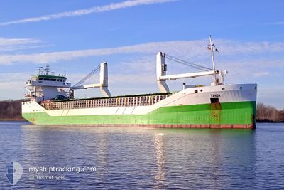
TANJA
General Cargo
Current Trip
| Time Travelled | 9 days |
|---|---|
| Remaining Time | --- |
| Distance Travelled | 2551.88 nm |
| Remaining Distance | --- |
| AVG Speed | 11.8 Knots |
| MAX Speed | 13.3 Knots |
| AVG Wind | 15.7 knots |
| MAX Wind | 33.3 knots |
| MIN Temp | 10.2°C / 50.36°F |
| MAX Temp | 19.1°C / 66.38°F |
| Draught | 6 m |
| Position Received | 2 d ago |
Current Position
| Longitude | --- |
|---|---|
| Latitude | --- |
| Status | Under way using engine |
| Speed | 11.3 Knots |
| Course | 358.8° |
| Area | North Atlantic Ocean |
| Station | T-AIS |
| Position Received | 2 d ago |
Information
The current position of TANJA is in North Atlantic Ocean with coordinates 39.25649° / -9.84819° as reported on 2025-03-21 00:01 by AIS to our vessel tracker app. The vessel's current speed is 11.3 Knots and is heading at the port of CUXHAVEN. The estimated time of arrival as calculated by MyShipTracking vessel tracking app is 2025-03-25 06:00 LT
The vessel TANJA (IMO: 9534444, MMSI: 304690000) is a General Cargo that was built in 2011 ( 14 years old ). It's sailing under the flag of [AG] Antigua Barbuda.
In this page you can find informations about the vessels current position, last detected port calls, and current voyage information. If the vessels is not in coverage by AIS you will find the latest position.
The current position of TANJA is detected by our AIS receivers and we are not responsible for the reliability of the data. The last position was recorded while the vessel was in Coverage by the Ais receivers of our vessel tracking app.
The current draught of TANJA as reported by AIS is 6 meters
Weather
| Temperature | 11.2°C / 52.16°F |
|---|---|
| Wind Speed | 24 knots |
| Direction | 280° W |
| Pressure | 1002.4 hPa |
| Humidity | 74 % |
| Cloud Coverage | 72 % |
Featured Company
Last Port Calls
| Port | Arrival | Departure | Time In Port |
|---|---|---|---|
| 2025-03-10 15:40 | 2025-03-13 11:30 | 2 d | |
| 2025-03-05 15:32 | 2025-03-06 21:16 | 1 d | |
| 2025-03-02 12:10 | 2025-03-03 13:39 | 1 d | |
| 2025-02-22 05:20 | 2025-02-25 17:45 | 3 d | |
| 2025-02-15 05:33 | 2025-02-15 11:29 | 5 h | |
| 2025-02-08 15:42 | 2025-02-08 16:45 | 1 h | |
| 2025-02-04 05:45 | 2025-02-06 07:17 | 2 d | |
| 2025-02-01 18:10 | 2025-02-03 07:24 | 1 d | |
| 2025-01-31 07:47 | 2025-01-31 07:50 | 2 m | |
| 2025-01-26 02:57 | 2025-01-29 09:00 | 3 d |
Last Trips
| Origin | Departure | Destination | Arrival | Distance | |
|---|---|---|---|---|---|
| 2025-03-07 00:16 | 2025-03-10 18:40 | 244.57 nm | |||
| 2025-03-03 16:39 | 2025-03-05 18:32 | 605.98 nm | |||
| 2025-02-25 18:45 | 2025-03-02 15:10 | 1494.23 nm | |||
| 2025-02-15 12:29 | 2025-02-22 06:20 | 567.49 nm | |||
| 2025-02-08 17:45 | 2025-02-15 06:33 | 1716.49 nm | |||
| 2025-02-06 08:17 | 2025-02-08 16:42 | 645.12 nm | |||
| 2025-02-03 08:24 | 2025-02-04 06:45 | 264.34 nm | |||
| 2025-01-31 08:50 | 2025-02-01 19:10 | 438.66 nm | |||
| 2025-01-29 10:00 | 2025-01-31 08:47 | 486.29 nm | |||
| 2025-01-21 16:26 | 2025-01-26 03:57 | 500.46 nm |
Events
| Time | Event | Details | Position / Dest | Info |
|---|---|---|---|---|
| 2025-03-21 00:08 | Status Changed | Default Under way using engine |
39.27776 / -9.84777
DECUX
|
Speed: 11.3 kn Course: 358.8° |
| 2025-03-21 00:01 | OUT of Coverage |
39.25649 / -9.84819
North Atlantic Ocean
DECUX
|
Speed: 11.3 kn Course: 358.8° |
|
| 2025-03-20 15:14 | Status Changed | Under way using engine Default |
37.58385 / -9.52242
DECUX
|
Speed: 10.5 kn Course: 346° |
| 2025-03-20 15:12 | Status Changed | Default Under way using engine |
37.57731 / -9.52019
DECUX
|
Speed: 10.4 kn Course: 347.5° |
| 2025-03-20 14:56 | Status Changed | Under way using engine Default |
37.53386 / -9.50528
DECUX
|
Speed: 10.7 kn Course: 341° |
| 2025-03-20 14:56 | Status Changed | Default Under way using engine |
37.53148 / -9.50448
DECUX
|
Speed: 10.6 kn Course: 338.9° |
| 2025-03-20 14:32 | Status Changed | Under way using engine Default |
37.46446 / -9.48524
DECUX
|
Speed: 10.4 kn Course: 349° |
| 2025-03-20 14:20 | IN Coverage |
37.46876 / -9.48627
North Atlantic Ocean
DECUX
|
Speed: 10.3 kn Course: 346.6° |
|
| 2025-03-20 08:12 | Status Changed | Default Under way using engine |
36.67621 / -8.90244
DECUX
|
Speed: 8.3 kn Course: 287.6° |
| 2025-03-20 08:04 | OUT of Coverage |
36.67079 / -8.88266
North Atlantic Ocean
DECUX
|
Speed: 8.3 kn Course: 287.6° |