
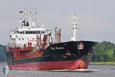
STOLT SEAGULL
Oil/Chemical Tanker
Current Trip
| Time Travelled | 9 h, 49 mins |
|---|---|
| Remaining Time | 1 day |
| Distance Travelled | 122.88 nm |
| Remaining Distance | 306.00 nm |
| AVG Speed | 12.9 Knots |
| MAX Speed | 13.6 Knots |
| AVG Wind | 8.4 knots |
| MAX Wind | 10 knots |
| MIN Temp | 4.2°C / 39.56°F |
| MAX Temp | 7.4°C / 45.32°F |
| Draught | 6.3 m |
| Position Received | 1 m ago |
Current Position
| Longitude | --- |
|---|---|
| Latitude | --- |
| Status | Under way using engine |
| Speed | 12.3 Knots |
| Course | 20.2° |
| Area | Baltic Sea |
| Station | T-AIS |
| Position Received | 1 m ago |
Information
The current position of STOLT SEAGULL is in Baltic Sea with coordinates 57.09855° / 17.55857° as reported on 2025-03-29 03:41 by AIS to our vessel tracker app. The vessel's current speed is 12.3 Knots and is heading at the port of RAUMA. The estimated time of arrival as calculated by MyShipTracking vessel tracking app is 2025-03-30 03:56 LT
The vessel STOLT SEAGULL (IMO: 9125645, MMSI: 235112571) is a Oil/Chemical Tanker that was built in 1997 ( 28 years old ). It's sailing under the flag of [GB] United Kingdom.
In this page you can find informations about the vessels current position, last detected port calls, and current voyage information. If the vessels is not in coverage by AIS you will find the latest position.
The current position of STOLT SEAGULL is detected by our AIS receivers and we are not responsible for the reliability of the data. The last position was recorded while the vessel was in Coverage by the Ais receivers of our vessel tracking app.
The current draught of STOLT SEAGULL as reported by AIS is 6.3 meters
Weather
| Temperature | 4.2°C / 39.56°F |
|---|---|
| Wind Speed | 7 knots |
| Direction | 166° SSE |
| Pressure | 1011.6 hPa |
| Humidity | 89.4 % |
| Cloud Coverage | --- |
Featured Company
Last Port Calls
| Port | Arrival | Departure | Time In Port |
|---|---|---|---|
| 2025-03-28 09:46 | 2025-03-28 17:54 | 8 h | |
| 2025-03-20 01:52 | 2025-03-25 20:35 | 5 d | |
| 2025-03-17 07:05 | 2025-03-17 22:00 | 14 h | |
| 2025-03-16 14:02 | 2025-03-16 15:51 | 1 h | |
| 2025-03-15 13:31 | 2025-03-16 12:52 | 23 h | |
| 2025-03-12 19:56 | 2025-03-14 03:44 | 1 d | |
| 2025-03-06 10:07 | 2025-03-07 11:49 | 1 d | |
| 2025-03-04 10:30 | 2025-03-06 07:48 | 1 d | |
| 2025-03-02 20:25 | 2025-03-04 09:59 | 1 d | |
| 2025-02-27 17:55 | 2025-03-01 18:04 | 2 d |
Most Visited Ports (Last year)
| Port | Arrivals | |
|---|---|---|
| 18 | ||
| 10 | ||
| 8 | ||
| 6 | ||
| 6 | ||
| 6 |
Last Trips
| Origin | Departure | Destination | Arrival | Distance | |
|---|---|---|---|---|---|
| 2025-03-25 21:35 | 2025-03-28 10:46 | 686.40 nm | |||
| 2025-03-17 23:00 | 2025-03-20 02:52 | 157.44 nm | |||
| 2025-03-16 16:51 | 2025-03-17 08:05 | 163.26 nm | |||
| 2025-03-16 13:52 | 2025-03-16 15:02 | 8.34 nm | |||
| 2025-03-14 04:44 | 2025-03-15 14:31 | 356.15 nm | |||
| 2025-03-07 12:49 | 2025-03-12 20:56 | 1373.64 nm | |||
| 2025-03-06 08:48 | 2025-03-06 11:07 | 20.56 nm | |||
| 2025-03-04 10:59 | 2025-03-04 11:30 | 2.21 nm | |||
| 2025-03-01 19:04 | 2025-03-02 21:25 | 108.49 nm | |||
| 2025-02-24 14:12 | 2025-02-27 18:55 | 350.69 nm |
Events
| Time | Event | Details | Position / Dest | Info |
|---|---|---|---|---|
| 2025-03-29 01:26 | Status Changed | Under way using engine Default |
56.65449 / 17.26135
SEKLR>FIRAU
|
Speed: 12.6 kn Course: 22° |
| 2025-03-29 01:10 | Status Changed | Default Under way using engine |
56.60200 / 17.22433
SEKLR>FIRAU
|
Speed: 12.5 kn Course: 20.2° |
| 2025-03-29 01:00 | Status Changed | Under way using engine Default |
56.56916 / 17.20199
SEKLR>FIRAU
|
Speed: 12.7 kn Course: 21° |
| 2025-03-29 00:22 | Status Changed | Default Under way using engine |
56.44428 / 17.11621
SEKLR>FIRAU
|
Speed: 12.7 kn Course: 20.3° |
| 2025-03-28 23:56 | Status Changed | Under way using engine Default |
56.35923 / 17.05786
SEKLR>FIRAU
|
Speed: 12.7 kn Course: 20° |
| 2025-03-28 23:38 | Status Changed | Default Under way using engine |
56.29817 / 17.01800
SEKLR>FIRAU
|
Speed: 12.7 kn Course: 20.6° |
| 2025-03-28 23:31 | Status Changed | Under way using engine Default |
56.27607 / 17.00348
SEKLR>FIRAU
|
Speed: 12.7 kn Course: 20° |
| 2025-03-28 23:30 | Status Changed | Default Under way using engine |
56.27183 / 17.00067
SEKLR>FIRAU
|
Speed: 12.7 kn Course: 20.6° |
| 2025-03-28 23:24 | Status Changed | Under way using engine Default |
56.25119 / 16.98681
SEKLR>FIRAU
|
Speed: 12.7 kn Course: 22° |
| 2025-03-28 23:10 | Status Changed | Default Under way using engine |
56.20610 / 16.95431
SEKLR>FIRAU
|
Speed: 12.9 kn Course: 21° |