
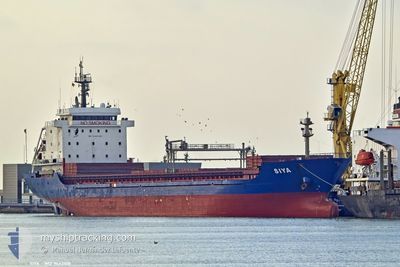
SIYA
General Cargo
Current Trip
| Time Travelled | 12 days |
|---|---|
| Remaining Time | --- |
| Distance Travelled | 2361.44 nm |
| Remaining Distance | --- |
| AVG Speed | 9.5 Knots |
| MAX Speed | 14.7 Knots |
| AVG Wind | 14.6 knots |
| MAX Wind | 35 knots |
| MIN Temp | 11°C / 51.8°F |
| MAX Temp | 18.6°C / 65.48°F |
| Draught | 6.8 m |
| Position Received | 2 m ago |
Current Position
| Longitude | --- |
|---|---|
| Latitude | --- |
| Status | Moored |
| Speed | |
| Course | 67° |
| Area | North Atlantic Ocean |
| Station | T-AIS |
| Position Received | 2 m ago |
Information
The current position of SIYA is in North Atlantic Ocean with coordinates 38.67962° / -9.18361° as reported on 2024-12-19 08:02 by AIS to our vessel tracker app. The vessel's current speed is 0 Knots
The vessel SIYA (IMO: 9442108, MMSI: 636020512) is a General Cargo that was built in 2007 ( 17 years old ). It's sailing under the flag of [LR] Liberia.
In this page you can find informations about the vessels current position, last detected port calls, and current voyage information. If the vessels is not in coverage by AIS you will find the latest position.
The current position of SIYA is detected by our AIS receivers and we are not responsible for the reliability of the data. The last position was recorded while the vessel was in Coverage by the Ais receivers of our vessel tracking app.
The current draught of SIYA as reported by AIS is 6.8 meters
Weather
| Temperature | 14.3°C / 57.74°F |
|---|---|
| Wind Speed | 7 knots |
| Direction | 283° WNW |
| Pressure | 1027.7 hPa |
| Humidity | 95.2 % |
| Cloud Coverage | 41 % |
Featured Company
Last Port Calls
| Port | Arrival | Departure | Time In Port |
|---|---|---|---|
| 2024-12-02 03:11 | 2024-12-06 21:59 | 4 d | |
| 2024-11-20 19:06 | 2024-11-26 20:36 | 6 d | |
| 2024-11-15 05:42 | 2024-11-17 12:51 | 2 d | |
| 2024-10-28 05:15 | 2024-11-04 16:20 | 7 d | |
| 2024-10-11 15:32 | 2024-10-15 20:18 | 4 d | |
| 2024-10-03 09:55 | 2024-10-05 15:43 | 2 d |
Most Visited Ports (Last year)
| Port | Arrivals | |
|---|---|---|
| 3 | ||
| 2 | ||
| 2 | ||
| 2 | ||
| 2 | ||
| 2 |
Last Trips
| Origin | Departure | Destination | Arrival | Distance | |
|---|---|---|---|---|---|
| 2024-11-26 22:36 | 2024-12-02 05:11 | 305.36 nm | |||
| 2024-11-17 16:51 | 2024-11-20 21:06 | 604.70 nm | |||
| 2024-11-04 17:20 | 2024-11-15 09:42 | 1545.16 nm | |||
| 2024-10-15 22:18 | 2024-10-28 06:15 | 2489.92 nm | |||
| 2024-10-05 16:43 | 2024-10-11 17:32 | 991.35 nm | |||
| 2024-09-22 12:46 | 2024-10-03 10:55 | 1616.05 nm |
Events
| Time | Event | Details | Position / Dest | Info |
|---|---|---|---|---|
| 2024-12-18 22:48 | Status Changed | Moored Under way using engine |
38.67973 / -9.18364
PT LIS
|
Speed: Course: 67° |
| 2024-12-18 22:09 | STOP Moving | 1.88 nm, West of ALMADA |
38.67982 / -9.18394
PT LIS
|
Speed: 0.3 kn Course: 71° |
| 2024-12-18 19:52 | START Moving | 1.59 nm, South of CASCAIS |
38.66642 / -9.41005
PT LIS
|
Speed: 3.2 kn Course: 172° |
| 2024-12-18 19:48 | Status Changed | Under way using engine At anchor |
38.66786 / -9.41063
PT LIS
|
Speed: 0.5 kn Course: 195° |
| 2024-12-18 08:33 | STOP Moving | 1.42 nm, South of CASCAIS |
38.66896 / -9.41190
PT LIS
|
Speed: 0.3 kn Course: 155° |
| 2024-12-18 08:23 | Status Changed | At anchor Under way using engine |
38.66773 / -9.41141
PT LIS
|
Speed: 0.8 kn Course: 180° |
| 2024-12-17 22:10 | Status Changed | Under way using engine Default |
36.88147 / -9.31644
PT LIS
|
Speed: 10.5 kn Course: 320° |
| 2024-12-17 21:19 | Status Changed | Default Under way using engine |
36.77185 / -9.18815
PT LIS
|
Speed: 10.5 kn Course: 298.6° |
| 2024-12-17 20:55 | Status Changed | Under way using engine Default |
36.74018 / -9.11447
PT LIS
|
Speed: 10.3 kn Course: 291° |
| 2024-12-17 20:55 | Status Changed | Default Under way using engine |
36.73966 / -9.11283
PT LIS
|
Speed: 10.3 kn Course: 288.2° |