
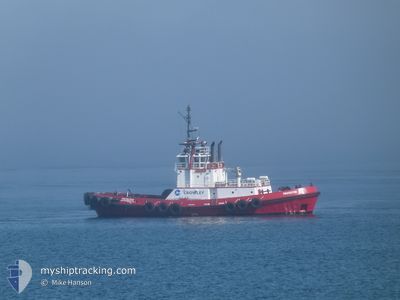
PROTECTOR
Tug
Current Trip
US^00K8>016C
| Time Travelled | 1 h, 31 mins |
|---|---|
| Remaining Time | --- |
| Distance Travelled | 13.77 nm |
| Remaining Distance | --- |
| AVG Speed | 10.1 Knots |
| MAX Speed | 10.7 Knots |
| AVG Wind | 2.8 knots |
| MAX Wind | 4 knots |
| MIN Temp | -1.8°C / 28.76°F |
| MAX Temp | 0.3°C / 32.54°F |
| Draught | 5 m |
| Position Received | Now |
Current Position
| Longitude | --- |
|---|---|
| Latitude | --- |
| Status | Under way using engine |
| Speed | 10 Knots |
| Course | 347.6° |
| Area | The Coastal Waters of Southeast Alaska and British Columbia |
| Station | T-AIS |
| Position Received | Now |
Info
Information
The current position of PROTECTOR is in The Coastal Waters of Southeast Alaska and British Columbia with coordinates 47.50929° / -122.41072° as reported on 2026-02-18 15:17 by AIS to our vessel tracker app. The vessel's current speed is 10 Knots
The vessel PROTECTOR (MMSI: 366887970) is a Tug that was built in 1996 ( 30 years old ). It's sailing under the flag of [US] USA.
In this page you can find informations about the vessels current position, last detected port calls, and current voyage information. If the vessels is not in coverage by AIS you will find the latest position.
The current position of PROTECTOR is detected by our AIS receivers and we are not responsible for the reliability of the data. The last position was recorded while the vessel was in Coverage by the Ais receivers of our vessel tracking app.
The current draught of PROTECTOR as reported by AIS is 5 meters
Weather
| Temperature | -1.8°C / 28.76°F |
|---|---|
| Wind Speed | 4 knots |
| Direction | 195° SSW |
| Pressure | 1005.6 hPa |
| Humidity | 97.2 % |
| Cloud Coverage | 55 % |
Featured Company
Last Port Calls
| Port | Arrival | Departure | Time In Port |
|---|---|---|---|
| 2026-02-18 04:12 | 2026-02-18 05:47 | 1 h | |
| 2026-02-16 18:43 | 2026-02-18 03:59 | 1 d | |
| 2026-02-15 06:47 | 2026-02-16 18:32 | 1 d | |
| 2026-02-14 17:54 | 2026-02-15 04:39 | 10 h | |
| 2026-02-14 00:29 | 2026-02-14 14:28 | 13 h | |
| 2026-02-13 17:07 | 2026-02-13 17:51 | 43 m | |
| 2026-02-13 02:30 | 2026-02-13 03:18 | 47 m | |
| 2026-02-12 12:26 | 2026-02-12 13:21 | 55 m | |
| 2026-02-12 09:28 | 2026-02-12 10:14 | 45 m | |
| 2026-02-11 12:56 | 2026-02-11 13:43 | 46 m |
Most Visited Ports (Last year)
| Port | Arrivals | |
|---|---|---|
| 165 | ||
| 164 | ||
| 80 | ||
| 67 | ||
| 64 | ||
| 52 |
Last Trips
| Origin | Departure | Destination | Arrival | Distance | |
|---|---|---|---|---|---|
| 2026-02-18 03:59 | 2026-02-18 04:12 | 0.67 nm | |||
| 2026-02-16 18:32 | 2026-02-16 18:43 | 0.24 nm | |||
| 2026-02-15 04:39 | 2026-02-15 06:47 | 4.30 nm | |||
| 2026-02-14 14:28 | 2026-02-14 17:54 | 23.58 nm | |||
| 2026-02-13 17:51 | 2026-02-14 00:29 | 68.83 nm | |||
| 2026-02-13 03:18 | 2026-02-13 17:07 | 49.48 nm | |||
| 2026-02-12 13:21 | 2026-02-13 02:30 | 33.89 nm | |||
| 2026-02-12 10:14 | 2026-02-12 12:26 | 2.42 nm | |||
| 2026-02-11 13:43 | 2026-02-12 09:28 | 64.60 nm | |||
| 2026-02-11 12:14 | 2026-02-11 12:56 | 2.70 nm |
Events
| Time | Event | Details | Position / Dest | Info |
|---|---|---|---|---|
| 2026-02-18 15:16 | Draught Changed | 5 5.8 |
47.50655 / -122.40982
US^00K8>016C
|
Speed: 10 kn Course: 347.6° |
| 2026-02-18 13:58 | Destination Changed | US^00K8>016C US^00K8>0YLX |
47.32313 / -122.44097
US^00K8>016C
|
Speed: 10.4 kn Course: 30.4° |
| 2026-02-18 13:48 | Status Changed | Under way using engine Default |
47.29664 / -122.44732
US^00K8>0YLX
|
Speed: 10.5 kn Course: 309° |
| 2026-02-18 13:47 | Status Changed | Default Under way using engine |
47.29588 / -122.44604
US^00K8>0YLX
|
Speed: 10.4 kn Course: 309° |
| 2026-02-18 13:47 | Status Changed | Under way using engine Default |
47.29557 / -122.44549
US^00K8>0YLX
|
Speed: 8.8 kn Course: 313° |
| 2026-02-18 13:47 | PORT DEPARTURE |
|
47.29557 / -122.44549
US^00K8>0YLX
|
Speed: 8.8 kn Course: 313° |
| 2026-02-18 13:39 | Status Changed | Default Under way using engine |
47.28278 / -122.42141
[US] TACOMA
|
Speed: 0.6 kn Course: 31° |
| 2026-02-18 13:39 | START Moving |
47.28278 / -122.42141
[US] TACOMA
|
Speed: 8.8 kn Course: 307° |
|
| 2026-02-18 13:24 | Status Changed | Under way using engine Default |
47.27668 / -122.41196
[US] TACOMA
|
Speed: Course: 40° |
| 2026-02-18 13:23 | Status Changed | Default Under way using engine |
47.27667 / -122.41195
[US] TACOMA
|
Speed: 0.1 kn Course: 38° |