
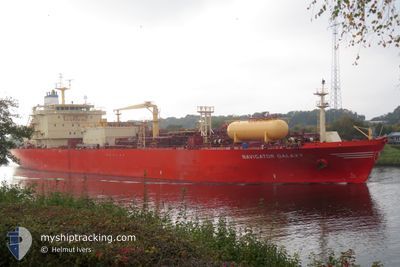
NAVIGATOR GALAXY
Lpg Tanker
Current Trip
| Time Travelled | 9 days |
|---|---|
| Remaining Time | --- |
| Distance Travelled | 2709.57 nm |
| Remaining Distance | --- |
| AVG Speed | 12.4 Knots |
| MAX Speed | 15.8 Knots |
| AVG Wind | 19.8 knots |
| MAX Wind | 35 knots |
| MIN Temp | 3.2°C / 37.76°F |
| MAX Temp | 18.7°C / 65.66°F |
| Draught | 6.8 m |
| Position Received | 5 d ago |
Current Position
| Longitude | --- |
|---|---|
| Latitude | --- |
| Status | Under way using engine |
| Speed | 9.1 Knots |
| Course | 219.3° |
| Area | English Channel |
| Station | T-AIS |
| Position Received | 5 d ago |
Info
Information
The current position of NAVIGATOR GALAXY is in English Channel with coordinates 49.49156° / -4.69590° as reported on 2025-12-10 04:56 by AIS to our vessel tracker app. The vessel's current speed is 9.1 Knots and is heading at the port of POINT LISAS. The estimated time of arrival as calculated by MyShipTracking vessel tracking app is 2025-12-21 12:00 LT
The vessel NAVIGATOR GALAXY (IMO: 9536363, MMSI: 636015946) is a Lpg Tanker that was built in 2011 ( 14 years old ). It's sailing under the flag of [LR] Liberia.
In this page you can find informations about the vessels current position, last detected port calls, and current voyage information. If the vessels is not in coverage by AIS you will find the latest position.
The current position of NAVIGATOR GALAXY is detected by our AIS receivers and we are not responsible for the reliability of the data. The last position was recorded while the vessel was in Coverage by the Ais receivers of our vessel tracking app.
The current draught of NAVIGATOR GALAXY as reported by AIS is 6.8 meters
Weather
| Temperature | 18.7°C / 65.66°F |
|---|---|
| Wind Speed | 12 knots |
| Direction | 52° NE |
| Pressure | 1029.6 hPa |
| Humidity | 62.6 % |
| Cloud Coverage | 63 % |
Featured Company
Last Port Calls
| Port | Arrival | Departure | Time In Port |
|---|---|---|---|
| 2025-12-05 14:49 | 2025-12-06 10:13 | 19 h | |
| 2025-12-02 21:38 | 2025-12-03 20:50 | 23 h | |
| 2025-11-24 10:12 | 2025-11-25 16:26 | 1 d | |
| 2025-11-21 01:23 | 2025-11-21 10:39 | 9 h | |
| 2025-11-11 18:19 | 2025-11-13 14:07 | 1 d | |
| 2025-10-23 01:50 | 2025-10-24 03:30 | 1 d | |
| 2025-10-05 16:56 | 2025-10-06 19:31 | 1 d | |
| 2025-10-05 09:14 | 2025-10-05 09:18 | 3 m | |
| 2025-10-03 22:22 | 2025-10-05 00:55 | 1 d | |
| 2025-10-03 13:19 | 2025-10-03 14:28 | 1 h |
Last Trips
| Origin | Departure | Destination | Arrival | Distance | |
|---|---|---|---|---|---|
| 2025-12-03 20:50 | 2025-12-05 14:49 | 365.70 nm | |||
| 2025-11-25 16:26 | 2025-12-02 21:38 | 2172.94 nm | |||
| 2025-11-21 10:39 | 2025-11-24 10:12 | 346.38 nm | |||
| 2025-11-13 14:07 | 2025-11-21 01:23 | 2208.75 nm | |||
| 2025-10-24 03:30 | 2025-11-11 18:19 | 5164.91 nm | |||
| 2025-10-06 19:31 | 2025-10-23 01:50 | 4984.54 nm | |||
| 2025-10-05 09:18 | 2025-10-05 16:56 | 81.26 nm | |||
| 2025-10-05 00:55 | 2025-10-05 09:14 | 49.95 nm | |||
| 2025-10-03 14:28 | 2025-10-03 22:22 | 49.56 nm | |||
| 2025-10-03 04:52 | 2025-10-03 13:19 | 85.47 nm |
Events
| Time | Event | Details | Position / Dest | Info |
|---|---|---|---|---|
| 2025-12-10 05:07 | Status Changed | Default Under way using engine |
49.46876 / -4.72126
DERSK>TTPTS
|
Speed: 9.1 kn Course: 219.3° |
| 2025-12-10 04:56 | Status Changed | Under way using engine Default |
49.49156 / -4.69590
DERSK>TTPTS
|
Speed: 9.4 kn Course: 223° |
| 2025-12-10 04:56 | OUT of Coverage |
49.49156 / -4.69590
English Channel
DERSK>TTPTS
|
Speed: 9.1 kn Course: 219.3° |
|
| 2025-12-10 04:55 | IN Coverage |
49.49156 / -4.69590
English Channel
DERSK>TTPTS
|
Speed: 9.1 kn Course: 219.3° |
|
| 2025-12-09 14:55 | Status Changed | Default Under way using engine |
50.28045 / -1.38437
DERSK>TTPTS
|
Speed: 11.7 kn Course: 258° |
| 2025-12-09 14:49 | OUT of Coverage |
50.28588 / -1.35441
English Channel
DERSK>TTPTS
|
Speed: 11.7 kn Course: 258° |
|
| 2025-12-09 14:42 | Status Changed | Under way using engine Default |
50.28965 / -1.31916
DERSK>TTPTS
|
Speed: 11.2 kn Course: 260° |
| 2025-12-09 14:23 | Status Changed | Default Under way using engine |
50.29682 / -1.22838
DERSK>TTPTS
|
Speed: 10.9 kn Course: 260.7° |
| 2025-12-09 14:17 | Status Changed | Under way using engine Default |
50.29939 / -1.20235
DERSK>TTPTS
|
Speed: 10.5 kn Course: 262° |
| 2025-12-09 14:15 | Status Changed | Default Under way using engine |
50.30062 / -1.19101
DERSK>TTPTS
|
Speed: 10.5 kn Course: 252.9° |