
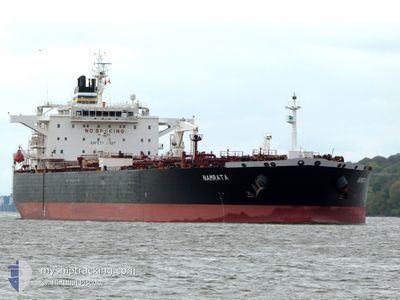
NAMRATA
Oil Products Tanker
Current Trip
| Time Travelled | 1 day |
|---|---|
| Remaining Time | 4 days |
| Distance Travelled | 550.81 nm |
| Remaining Distance | 1172.61 nm |
| AVG Speed | 13.1 Knots |
| MAX Speed | 15.9 Knots |
| AVG Wind | 10.9 knots |
| MAX Wind | 17.9 knots |
| MIN Temp | 8.1°C / 46.58°F |
| MAX Temp | 12.6°C / 54.68°F |
| Draught | 8.2 m |
| Position Received | 1 h, 11 m ago |
Current Position
| Longitude | -1.05042° |
|---|---|
| Latitude | 50.30303° |
| Status | Under way using engine |
| Speed | 11.7 Knots |
| Course | 253.7° |
| Area | English Channel |
| Station | T-AIS |
| Position Received | 1 h, 11 m ago |
Info
Information
The current position of NAMRATA is in English Channel with coordinates 50.30303° / -1.05042° as reported on 2024-04-30 14:10 by AIS to our vessel tracker app. The vessel's current speed is 11.7 Knots and is heading at the port of GIBRALTAR. The estimated time of arrival as calculated by MyShipTracking vessel tracking app is 2024-05-04 21:43 LT
The vessel NAMRATA (IMO: 9401154, MMSI: 248416000) is a Oil Products Tanker that was built in 2008 ( 16 years old ). It's sailing under the flag of [MT] Malta.
In this page you can find informations about the vessels current position, last detected port calls, and current voyage information. If the vessels is not in coverage by AIS you will find the latest position.
The current position of NAMRATA is detected by our AIS receivers and we are not responsible for the reliability of the data. The last position was recorded while the vessel was in Coverage by the Ais receivers of our vessel tracking app.
The current draught of NAMRATA as reported by AIS is 8.2 meters
Weather
| Temperature | 12.1°C / 53.78°F |
|---|---|
| Wind Speed | 9 knots |
| Direction | 136° SE |
| Pressure | 1007.7 hPa |
| Humidity | 83 % |
| Cloud Coverage | 100 % |
Featured Company
Last Port Calls
| Port | Arrival | Departure | Time In Port |
|---|---|---|---|
| 2024-04-25 13:55 | 2024-04-28 20:06 | 3 d | |
| 2024-04-21 13:00 | 2024-04-23 05:56 | 1 d | |
| 2024-04-09 06:07 | 2024-04-09 14:56 | 8 h | |
| 2024-04-05 19:55 | 2024-04-06 20:40 | 1 d | |
| 2024-03-30 05:51 | 2024-03-30 14:53 | 9 h | |
| 2024-03-15 23:39 | 2024-03-19 05:39 | 3 d | |
| 2024-02-29 11:16 | 2024-02-29 20:49 | 9 h | |
| 2024-02-16 04:00 | 2024-02-17 21:07 | 1 d | |
| 2024-02-06 04:06 | 2024-02-06 13:14 | 9 h |
Most Visited Ports (Last year)
| Port | Arrivals | |
|---|---|---|
| 8 | ||
| 2 | ||
| 1 | ||
| 1 | ||
| 1 | ||
| 1 |
Last Trips
| Origin | Departure | Destination | Arrival | Distance | |
|---|---|---|---|---|---|
| 2024-04-23 07:56 | 2024-04-25 15:55 | 446.07 nm | |||
| 2024-04-06 23:40 | 2024-04-21 15:00 | 3868.46 nm | |||
| 2024-04-06 23:40 | 2024-04-09 08:07 | 511.69 nm | |||
| 2024-03-19 06:39 | 2024-04-05 22:55 | 3965.14 nm | |||
| 2024-03-19 06:39 | 2024-03-30 07:51 | 3215.12 nm | |||
| 2024-02-18 01:07 | 2024-03-16 00:39 | 6409.24 nm | |||
| 2024-02-18 01:07 | 2024-02-29 13:16 | 2944.08 nm | |||
| 2023-12-08 10:20 | 2024-02-16 08:00 | 8680.80 nm | |||
| 2023-12-08 10:20 | 2024-02-06 06:06 | 5683.39 nm |
Events
| Time | Event | Details | Position / Dest | Info |
|---|---|---|---|---|
| 2024-04-30 14:18 | Status Changed | Default Under way using engine |
50.29595 / -1.08919
GIBRALTAR
|
Speed: 11.7 kn Course: 253.7° |
| 2024-04-30 14:10 | OUT of Coverage |
50.30303 / -1.05042
English Channel
GIBRALTAR
|
Speed: 11.7 kn Course: 253.7° |
|
| 2024-04-30 05:20 | Detected in Sea | United Kingdom part of the English Channel |
51.05494 / 1.49853
English Channel
GIBRALTAR
|
Speed: 11.1 kn Course: 222.4° |
| 2024-04-30 02:34 | Draught Changed | 8.2 8.3 |
51.47678 / 1.96625
GIBRALTAR
|
Speed: 12.8 kn Course: 224.6° |
| 2024-04-30 00:38 | Change Sea Area | United Kingdom part of the North Sea Belgian part of the North Sea |
51.79730 / 2.47007
North Sea
GIBRALTAR
|
Speed: 14.7 kn Course: 221.5° |
| 2024-04-30 00:20 | Change Sea Area | Belgian part of the North Sea Dutch part of the North Sea |
51.85281 / 2.54912
North Sea
GIBRALTAR
|
Speed: 15 kn Course: 215.8° |
| 2024-04-29 23:59 | Change Sea Area | Dutch part of the North Sea United Kingdom part of the North Sea |
51.93366 / 2.59310
North Sea
GIBRALTAR
|
Speed: 14.7 kn Course: 185.1° |
| 2024-04-29 22:59 | Status Changed | Under way using engine Default |
52.16824 / 2.68557
GIBRALTAR
|
Speed: 14.4 kn Course: 202° |
| 2024-04-29 22:57 | Status Changed | Default Under way using engine |
52.17719 / 2.69137
GIBRALTAR
|
Speed: 14.3 kn Course: 201.6° |
| 2024-04-29 22:49 | Change Sea Area | United Kingdom part of the North Sea Dutch part of the North Sea |
52.20461 / 2.70914
North Sea
GIBRALTAR
|
Speed: 14.3 kn Course: 201.6° |