
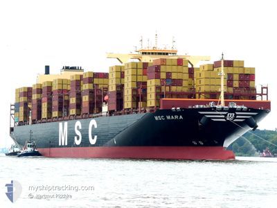
MSC MARA
Cargo A
Current Trip
| Time Travelled | 1 day |
|---|---|
| Remaining Time | 14 h, 37 mins |
| Distance Travelled | 242.56 nm |
| Remaining Distance | 170.38 nm |
| AVG Speed | 10.8 Knots |
| MAX Speed | 16.4 Knots |
| AVG Wind | 9.8 knots |
| MAX Wind | 14 knots |
| MIN Temp | 5.8°C / 42.44°F |
| MAX Temp | 8.9°C / 48.02°F |
| Draught | 14.2 m |
| Position Received | 2 h, 11 m ago |
Current Position
| Longitude | --- |
|---|---|
| Latitude | --- |
| Status | Under way using engine |
| Speed | 10.4 Knots |
| Course | 82.1° |
| Area | North Sea |
| Station | T-AIS |
| Position Received | 2 h, 11 m ago |
Info
Information
The current position of MSC MARA is in North Sea with coordinates 54.04939° / 5.24659° as reported on 2025-03-07 02:01 by AIS to our vessel tracker app. The vessel's current speed is 10.4 Knots and is heading at the port of HAMBURG. The estimated time of arrival as calculated by MyShipTracking vessel tracking app is 2025-03-07 18:50 LT
The vessel MSC MARA (IMO: 9932892, MMSI: 636021470) is a Cargo A It's sailing under the flag of [LR] Liberia.
In this page you can find informations about the vessels current position, last detected port calls, and current voyage information. If the vessels is not in coverage by AIS you will find the latest position.
The current position of MSC MARA is detected by our AIS receivers and we are not responsible for the reliability of the data. The last position was recorded while the vessel was in Coverage by the Ais receivers of our vessel tracking app.
The current draught of MSC MARA as reported by AIS is 14.2 meters
Weather
| Temperature | 6.9°C / 44.42°F |
|---|---|
| Wind Speed | 13 knots |
| Direction | 197° SSW |
| Pressure | 1014.4 hPa |
| Humidity | 85.6 % |
| Cloud Coverage | 35 % |
Featured Company
Last Port Calls
| Port | Arrival | Departure | Time In Port |
|---|---|---|---|
| 2025-03-03 18:33 | 2025-03-06 02:52 | 2 d | |
| 2025-02-27 12:14 | 2025-03-01 11:26 | 1 d | |
| 2025-01-31 07:17 | 2025-02-02 00:13 | 1 d | |
| 2025-01-25 22:53 | 2025-01-27 09:48 | 1 d | |
| 2025-01-20 14:49 | 2025-01-21 16:21 | 1 d | |
| 2025-01-10 16:05 | 2025-01-12 02:45 | 1 d |
Most Visited Ports (Last year)
| Port | Arrivals | |
|---|---|---|
| 3 | ||
| 3 | ||
| 3 | ||
| 3 | ||
| 2 | ||
| 2 |
Last Trips
| Origin | Departure | Destination | Arrival | Distance | |
|---|---|---|---|---|---|
| 2025-03-01 11:26 | 2025-03-03 19:33 | 229.28 nm | |||
| 2025-02-02 05:43 | 2025-02-27 12:14 | 10652.52 nm | |||
| 2025-01-27 17:48 | 2025-01-31 12:47 | 1614.40 nm | |||
| 2025-01-22 00:21 | 2025-01-26 06:53 | 1529.06 nm | |||
| 2025-01-12 10:45 | 2025-01-20 22:49 | 1503.07 nm | |||
| 2024-12-23 09:29 | 2025-01-11 00:05 | 6801.10 nm |
Events
| Time | Event | Details | Position / Dest | Info |
|---|---|---|---|---|
| 2025-03-07 02:04 | Status Changed | Default Under way using engine |
54.05047 / 5.26134
BE ANR > DE HAM
|
Speed: 10.4 kn Course: 82.1° |
| 2025-03-07 02:01 | OUT of Coverage |
54.04939 / 5.24659
North Sea
BE ANR > DE HAM
|
Speed: 10.4 kn Course: 82.1° |
|
| 2025-03-07 01:46 | Status Changed | Under way using engine Default |
54.04343 / 5.17281
BE ANR > DE HAM
|
Speed: 10.3 kn Course: 77° |
| 2025-03-07 01:46 | IN Coverage |
54.04343 / 5.17281
North Sea
BE ANR > DE HAM
|
Speed: 10.5 kn Course: 81.5° |
|
| 2025-03-06 23:46 | Status Changed | Default Under way using engine |
53.73893 / 4.91639
BE ANR > DE HAM
|
Speed: 10.9 kn Course: 21° |
| 2025-03-06 23:40 | Status Changed | Under way using engine Default |
53.72049 / 4.90513
BE ANR > DE HAM
|
Speed: 10.9 kn Course: 20° |
| 2025-03-06 23:40 | OUT of Coverage |
53.72049 / 4.90513
North Sea
BE ANR > DE HAM
|
Speed: 10.9 kn Course: 21° |
|
| 2025-03-06 23:30 | Status Changed | Default Under way using engine |
53.69191 / 4.88806
BE ANR > DE HAM
|
Speed: 11.1 kn Course: 22.2° |
| 2025-03-06 08:20 | Change Sea Area | Dutch part of the North Sea Belgian part of the North Sea |
51.54198 / 3.12566
North Sea
BE ANR > DE HAM
|
Speed: 16.2 kn Course: 43.3° |
| 2025-03-06 06:53 | Change Sea Area | Belgian part of the North Sea Dutch part of the North Sea |
51.40682 / 3.32238
North Sea
BE ANR > DE HAM
|
Speed: 15.1 kn Course: 276.8° |