
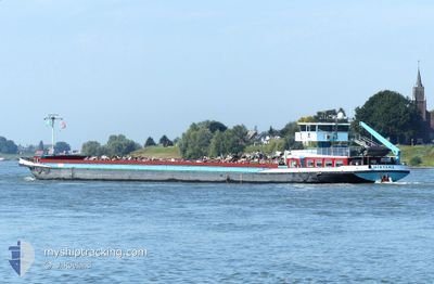
MIRYANA
Cargo
Current Trip
Current Position
| Longitude | --- |
|---|---|
| Latitude | --- |
| Status | Under way using engine |
| Speed | |
| Course | --- |
| Area | North Sea |
| Station | T-AIS |
| Position Received | 1 m ago |
Info
Information
The current position of MIRYANA is in North Sea with coordinates 51.85705° / 6.09117° as reported on 2025-12-05 16:31 by AIS to our vessel tracker app. The vessel's current speed is 0 Knots and is currently inside the port of LOBITH.
The vessel MIRYANA (IMO: 2321599, MMSI: 244110172) is a Cargo It's sailing under the flag of [NL] Netherlands.
In this page you can find informations about the vessels current position, last detected port calls, and current voyage information. If the vessels is not in coverage by AIS you will find the latest position.
The current position of MIRYANA is detected by our AIS receivers and we are not responsible for the reliability of the data. The last position was recorded while the vessel was in Coverage by the Ais receivers of our vessel tracking app.
The current draught of MIRYANA as reported by AIS is 1.8 meters
Weather
| Temperature | 4.8°C / 40.64°F |
|---|---|
| Wind Speed | 6 knots |
| Direction | 179° S |
| Pressure | 1011 hPa |
| Humidity | 88 % |
| Cloud Coverage | 32 % |
Featured Company
Last Port Calls
| Port | Arrival | Departure | Time In Port |
|---|---|---|---|
| 2025-12-04 08:30 | |||
| 2025-11-16 18:12 | 2025-11-18 06:44 | 1 d | |
| 2025-11-15 15:26 | 2025-11-16 09:15 | 17 h | |
| 2025-11-11 19:18 | 2025-11-12 14:25 | 19 h | |
| 2025-11-10 17:11 | 2025-11-11 17:39 | 1 d | |
| 2025-11-07 13:42 | 2025-11-10 09:42 | 2 d | |
| 2025-11-03 20:58 | 2025-11-04 10:24 | 13 h | |
| 2025-11-03 19:51 | 2025-11-03 20:26 | 34 m | |
| 2025-10-28 12:16 | 2025-10-29 14:17 | 1 d | |
| 2025-10-10 06:54 | 2025-10-10 15:40 | 8 h |
Last Trips
| Origin | Departure | Destination | Arrival | Distance | |
|---|---|---|---|---|---|
| 2025-11-18 06:44 | 2025-12-04 08:30 | 131.05 nm | |||
| 2025-11-16 09:15 | 2025-11-16 18:12 | 71.17 nm | |||
| 2025-11-12 14:25 | 2025-11-15 15:26 | 127.46 nm | |||
| 2025-11-11 17:39 | 2025-11-11 19:18 | 14.72 nm | |||
| 2025-11-10 09:42 | 2025-11-10 17:11 | 62.84 nm | |||
| 2025-11-04 10:24 | 2025-11-07 13:42 | 103.09 nm | |||
| 2025-11-03 20:26 | 2025-11-03 20:58 | 3.85 nm | |||
| 2025-10-29 14:17 | 2025-11-03 19:51 | 126.76 nm | |||
| 2025-10-10 15:40 | 2025-10-28 12:16 | 165.53 nm | |||
| 2025-10-10 05:03 | 2025-10-10 06:54 | 12.36 nm |
Events
| Time | Event | Details | Position / Dest | Info |
|---|---|---|---|---|
| 2025-12-04 07:33 | STOP Moving |
51.85732 / 6.09024
[NL] LOBITH
|
Speed: Course: 511° |
|
| 2025-12-04 07:30 | PORT ARRIVAL |
|
51.85544 / 6.08962
[NL] LOBITH
|
Speed: 2.7 kn Course: 511° |
| 2025-12-04 06:10 | START Moving | 1.52 nm, North West of ANGEREN |
51.93706 / 5.96220
ROYERSSLUIS ANTWERPE
|
Speed: 3.5 kn Course: 162.3° |
| 2025-12-03 22:29 | STOP Moving | 1.64 nm, North West of ANGEREN |
51.93880 / 5.96068
ROYERSSLUIS ANTWERPE
|
Speed: Course: 511° |
| 2025-12-03 19:29 | Destination Changed | ROYERSSLUIS ANTWERPE ENSCHEDE |
52.04041 / 6.11116
ROYERSSLUIS ANTWERPE
|
Speed: 4.6 kn Course: 164° |
| 2025-12-03 19:29 | ETA Changed | 2025/12/01 06:51 2025/11/19 08:58 |
52.04041 / 6.11116
ROYERSSLUIS ANTWERPE
|
Speed: 4.6 kn Course: 164° |
| 2025-12-03 19:20 | IN Coverage |
52.05006 / 6.11773
North Sea
|
Speed: 4.6 kn Course: 224° |