
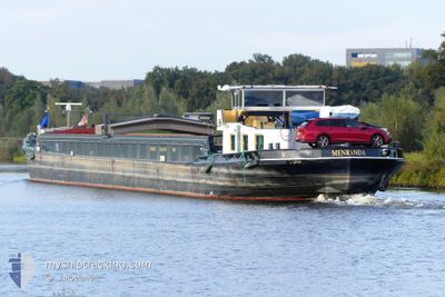
MENRANDA
Cargo
Current Trip
TELTOWKANAL
| Time Travelled | 1 day |
|---|---|
| Remaining Time | --- |
| Distance Travelled | 59.58 nm |
| Remaining Distance | --- |
| AVG Speed | 7.7 Knots |
| MAX Speed | 10.3 Knots |
| AVG Wind | 11.5 knots |
| MAX Wind | 14 knots |
| MIN Temp | 10°C / 50°F |
| MAX Temp | 13.2°C / 55.76°F |
| Draught | 1.6 m |
| Position Received | 10 h, 47 m ago |
Current Position
| Longitude | --- |
|---|---|
| Latitude | --- |
| Status | Under way using engine |
| Speed | 10.1 Knots |
| Course | 85.5° |
| Area | North Sea |
| Station | T-AIS |
| Position Received | 10 h, 47 m ago |
Info
Information
The current position of MENRANDA is in North Sea with coordinates 51.81481° / 4.78524° as reported on 2025-12-10 19:55 by AIS to our vessel tracker app. The vessel's current speed is 10.1 Knots
The vessel MENRANDA (MMSI: 244670579) is a Cargo It's sailing under the flag of [NL] Netherlands.
In this page you can find informations about the vessels current position, last detected port calls, and current voyage information. If the vessels is not in coverage by AIS you will find the latest position.
The current position of MENRANDA is detected by our AIS receivers and we are not responsible for the reliability of the data. The last position was recorded while the vessel was in Coverage by the Ais receivers of our vessel tracking app.
The current draught of MENRANDA as reported by AIS is 1.6 meters
Weather
| Temperature | 10.7°C / 51.26°F |
|---|---|
| Wind Speed | 12 knots |
| Direction | 244° WSW |
| Pressure | 1020.4 hPa |
| Humidity | 88 % |
| Cloud Coverage | 100 % |
Featured Company
Last Port Calls
| Port | Arrival | Departure | Time In Port |
|---|---|---|---|
| 2025-12-09 13:16 | 2025-12-09 16:38 | 3 h | |
| 2025-12-09 09:14 | 2025-12-09 10:22 | 1 h | |
| 2025-12-08 22:41 | 2025-12-09 07:53 | 9 h | |
| 2025-12-06 11:29 | 2025-12-06 13:20 | 1 h | |
| 2025-11-20 20:36 | 2025-11-21 04:59 | 8 h | |
| 2025-11-20 15:15 | 2025-11-20 17:30 | 2 h | |
| 2025-11-19 20:24 | 2025-11-20 05:07 | 8 h | |
| 2025-11-19 15:49 | 2025-11-19 16:39 | 50 m | |
| 2025-11-18 17:16 | 2025-11-19 13:18 | 20 h | |
| 2025-11-17 19:15 | 2025-11-17 21:06 | 1 h |
Last Trips
| Origin | Departure | Destination | Arrival | Distance | |
|---|---|---|---|---|---|
| 2025-12-09 10:22 | 2025-12-09 13:16 | 23.72 nm | |||
| 2025-12-09 07:53 | 2025-12-09 09:14 | 8.80 nm | |||
| 2025-12-06 13:20 | 2025-12-08 22:41 | 34.16 nm | |||
| 2025-11-21 04:59 | 2025-12-06 11:29 | 675.49 nm | |||
| 2025-11-20 17:30 | 2025-11-20 20:36 | 14.55 nm | |||
| 2025-11-20 05:07 | 2025-11-20 15:15 | 64.73 nm | |||
| 2025-11-19 16:39 | 2025-11-19 20:24 | 28.30 nm | |||
| 2025-11-19 13:18 | 2025-11-19 15:49 | 23.03 nm | |||
| 2025-11-17 21:06 | 2025-11-18 17:16 | 55.16 nm | |||
| 2025-11-02 15:14 | 2025-11-17 19:15 | 667.79 nm |
Events
| Time | Event | Details | Position / Dest | Info |
|---|---|---|---|---|
| 2025-12-10 19:55 | OUT of Coverage |
51.81481 / 4.78524
North Sea
TELTOWKANAL
|
Speed: 10.1 kn Course: 85.5° |
|
| 2025-12-10 19:02 | ETA Changed | 2025/12/16 06:15 2025/12/17 05:28 |
51.78011 / 4.62845
TELTOWKANAL
|
Speed: 6.1 kn Course: 359.4° |
| 2025-12-10 17:34 | START Moving | 1.13 nm, West of WILLEMSTAD |
51.69022 / 4.41036
TELTOWKANAL
|
Speed: 3.1 kn Course: 50° |
| 2025-12-10 16:51 | STOP Moving | 1.68 nm, East of OOLTGENSPLAAT |
51.68346 / 4.39808
TELTOWKANAL
|
Speed: Course: 511° |
| 2025-12-10 14:13 | START Moving | 3.2 nm, South West of BERGEN OP ZOOM |
51.44997 / 4.22965
TELTOWKANAL
|
Speed: 4.8 kn Course: 356.3° |
| 2025-12-10 14:11 | Status Changed | Under way using engine Moored |
51.44814 / 4.22986
TELTOWKANAL
|
Speed: 0.6 kn Course: 511° |
| 2025-12-10 14:08 | Status Changed | Moored Under way using engine |
51.44805 / 4.22985
TELTOWKANAL
|
Speed: Course: 511° |
| 2025-12-10 13:50 | STOP Moving | 3.3 nm, South West of BERGEN OP ZOOM |
51.44803 / 4.22987
TELTOWKANAL
|
Speed: Course: 511° |
| 2025-12-10 13:39 | START Moving | 3.56 nm, South West of BERGEN OP ZOOM |
51.44306 / 4.23064
TELTOWKANAL
|
Speed: 3.1 kn Course: 359.4° |
| 2025-12-10 13:23 | STOP Moving | 3.7 nm, South of BERGEN OP ZOOM |
51.44052 / 4.23104
TELTOWKANAL
|
Speed: 0.2 kn Course: 511° |