
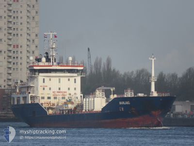
MAINLAND
Oil/Chemical Tanker
Current Trip
| Time Travelled | 8 h, 0 mins |
|---|---|
| Remaining Time | 2 days |
| Distance Travelled | 41.82 nm |
| Remaining Distance | 358.42 nm |
| AVG Speed | 6.6 Knots |
| MAX Speed | 8 Knots |
| AVG Wind | 8.3 knots |
| MAX Wind | 9.1 knots |
| MIN Temp | 10.4°C / 50.72°F |
| MAX Temp | 17.3°C / 63.14°F |
| Draught | 6.5 m |
| Position Received | Now |
Current Position
| Longitude | 9.29951° |
|---|---|
| Latitude | 54.02470° |
| Status | Under way using engine |
| Speed | 7.2 Knots |
| Course | 188.9° |
| Area | Baltic Sea |
| Station | T-AIS |
| Position Received | Now |
Info
Information
The current position of MAINLAND is in Baltic Sea with coordinates 54.02470° / 9.29951° as reported on 2024-04-30 22:32 by AIS to our vessel tracker app. The vessel's current speed is 7.2 Knots and is heading at the port of ANTWERP. The estimated time of arrival as calculated by MyShipTracking vessel tracking app is 2024-05-03 04:04 LT
The vessel MAINLAND (IMO: 9431056, MMSI: 249446000) is a Oil/Chemical Tanker that was built in 2008 ( 16 years old ). It's sailing under the flag of [MT] Malta.
In this page you can find informations about the vessels current position, last detected port calls, and current voyage information. If the vessels is not in coverage by AIS you will find the latest position.
The current position of MAINLAND is detected by our AIS receivers and we are not responsible for the reliability of the data. The last position was recorded while the vessel was in Coverage by the Ais receivers of our vessel tracking app.
The current draught of MAINLAND as reported by AIS is 6.5 meters
Weather
| Temperature | 11.4°C / 52.52°F |
|---|---|
| Wind Speed | 7 knots |
| Direction | 59° ENE |
| Pressure | 1014 hPa |
| Humidity | 96.5 % |
| Cloud Coverage | 36 % |
Featured Company
Last Port Calls
| Port | Arrival | Departure | Time In Port |
|---|---|---|---|
| 2024-04-30 12:57 | 2024-04-30 14:33 | 1 h | |
| 2024-04-27 11:04 | 2024-04-28 03:02 | 15 h | |
| 2024-04-22 08:44 | 2024-04-23 13:19 | 1 d | |
| 2024-04-19 16:39 | 2024-04-20 13:25 | 20 h | |
| 2024-04-15 03:06 | 2024-04-16 05:36 | 1 d | |
| 2024-04-12 03:52 | 2024-04-13 12:15 | 1 d | |
| 2024-04-10 15:58 | 2024-04-10 16:41 | 43 m | |
| 2024-04-07 17:39 | 2024-04-10 08:39 | 2 d | |
| 2024-04-04 17:22 | 2024-04-06 02:36 | 1 d | |
| 2024-03-30 17:15 | 2024-03-31 18:17 | 1 d |
Most Visited Ports (Last year)
| Port | Arrivals | |
|---|---|---|
| 8 | ||
| 7 | ||
| 6 | ||
| 6 | ||
| 5 | ||
| 5 |
Last Trips
| Origin | Departure | Destination | Arrival | Distance | |
|---|---|---|---|---|---|
| 2024-04-28 06:02 | 2024-04-30 14:57 | 639.62 nm | |||
| 2024-04-23 15:19 | 2024-04-27 14:04 | 680.12 nm | |||
| 2024-04-20 15:25 | 2024-04-22 10:44 | 349.53 nm | |||
| 2024-04-16 07:36 | 2024-04-19 18:39 | 787.14 nm | |||
| 2024-04-13 14:15 | 2024-04-15 05:06 | 366.63 nm | |||
| 2024-04-10 18:41 | 2024-04-12 05:52 | 311.98 nm | |||
| 2024-04-10 10:39 | 2024-04-10 17:58 | 85.06 nm | |||
| 2024-04-06 04:36 | 2024-04-07 19:39 | 388.62 nm | |||
| 2024-03-31 20:17 | 2024-04-04 19:22 | 505.89 nm | |||
| 2024-03-28 18:04 | 2024-03-30 18:15 | 533.89 nm |
Events
| Time | Event | Details | Position / Dest | Info |
|---|---|---|---|---|
| 2024-04-30 22:26 | START Moving | 1.17 nm, North of HOCHDONN |
54.03816 / 9.30222
BEANR
|
Speed: 3.7 kn Course: 186° |
| 2024-04-30 22:10 | STOP Moving | 1.29 nm, North of HOCHDONN |
54.04005 / 9.30283
BEANR
|
Speed: 0.3 kn Course: 191° |
| 2024-04-30 19:52 | START Moving | 6.82 nm, North East of FISCHERHUTTE |
54.19909 / 9.55086
BEANR
|
Speed: 5.6 kn Course: 229.9° |
| 2024-04-30 19:00 | STOP Moving | 6.93 nm, North East of FISCHERHUTTE |
54.20034 / 9.55340
BEANR
|
Speed: 0.3 kn Course: 234° |
| 2024-04-30 15:09 | START Moving | 2.37 nm, West of STICKENHΟRN SPORT |
54.37182 / 10.10307
BEANR
|
Speed: 3.1 kn Course: 279° |
| 2024-04-30 14:50 | STOP Moving | 2.22 nm, West of STICKENHΟRN SPORT |
54.37119 / 10.10783
BEANR
|
Speed: 0.3 kn Course: 282° |
| 2024-04-30 14:33 | PORT DEPARTURE |
|
54.36664 / 10.13533
BEANR
|
Speed: 5.2 kn Course: 287° |
| 2024-04-30 14:32 | START Moving |
54.36619 / 10.13811
[DE] KIEL
|
Speed: 4.7 kn Course: 285° |
|
| 2024-04-30 13:51 | STOP Moving |
54.36577 / 10.14124
[DE] KIEL
|
Speed: 0.3 kn Course: 285° |
|
| 2024-04-30 13:35 | START Moving |
54.36164 / 10.15695
[DE] KIEL
|
Speed: 4.2 kn Course: 352° |