
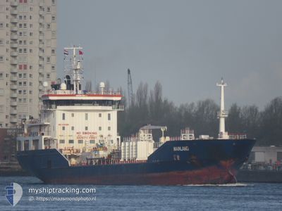
MAINLAND
Oil/Chemical Tanker
Current Trip
| Time Travelled | 6 h, 49 mins |
|---|---|
| Remaining Time | 4 days |
| Distance Travelled | 66.22 nm |
| Remaining Distance | 1132.96 nm |
| AVG Speed | 10.5 Knop |
| MAX Speed | 11.8 Knop |
| AVG Wind | 7.2 knots |
| MAX Wind | 9.8 knots |
| MIN Temp | 3°C / 37.4°F |
| MAX Temp | 3.7°C / 38.66°F |
| Djupgående | 6.5 m |
| Position mottagen | 1 m sen |
Current Position
| Longitud | 22.92613° |
|---|---|
| Latitude | 59.55454° |
| Status | Under way using engine |
| Fart | 10.4 Knop |
| Kurs | 255° |
| Område | Baltic Sea |
| Station | T-AIS |
| Position mottagen | 1 m sen |
Info
Information
The current position of MAINLAND is in Baltic Sea with coordinates 59.55454° / 22.92613° as reported on 2024-04-28 09:50 by AIS to our vessel tracker app. The vessel's current speed is 10.4 Knop and is heading at the port of ANTWERP. The estimated time of arrival as calculated by MyShipTracking vessel tracking app is 2024-05-03 00:26 LT
The vessel MAINLAND (IMO: 9431056, MMSI: 249446000) is a Oil/Chemical Tanker that was built in 2008 ( 16 År gammal ). It's sailing under the flag of [MT] Malta.
In this page you can find informations about the vessels current position, last detected port calls, and current voyage information. If the vessels is not in coverage by AIS you will find the latest position.
The current position of MAINLAND is detected by our AIS receivers and we are not responsible for the reliability of the data. The last position was recorded while the vessel was in Coverage by the Ais receivers of our vessel tracking app.
The current draught of MAINLAND as reported by AIS is 6.5 meters
Weather
| Temperature | 3.1°C / 37.58°F |
|---|---|
| Wind Speed | 2 knots |
| Direction | 350° N |
| Pressure | 1025 hPa |
| Humidity | 89.4 % |
| Cloud Coverage | 100 % |
Featured Company
Last Port Calls
| Port | Arrival | Departure | Time In Port |
|---|---|---|---|
| 2024-04-27 11:04 | 2024-04-28 03:02 | 15 h | |
| 2024-04-22 08:44 | 2024-04-23 13:19 | 1 d | |
| 2024-04-19 16:39 | 2024-04-20 13:25 | 20 h | |
| 2024-04-15 03:06 | 2024-04-16 05:36 | 1 d | |
| 2024-04-12 03:52 | 2024-04-13 12:15 | 1 d | |
| 2024-04-10 15:58 | 2024-04-10 16:41 | 43 m | |
| 2024-04-07 17:39 | 2024-04-10 08:39 | 2 d | |
| 2024-04-04 17:22 | 2024-04-06 02:36 | 1 d | |
| 2024-03-30 17:15 | 2024-03-31 18:17 | 1 d | |
| 2024-03-28 05:53 | 2024-03-28 18:04 | 12 h |
Most Visited Ports (Last year)
| Port | Arrivals | |
|---|---|---|
| 8 | ||
| 7 | ||
| 6 | ||
| 6 | ||
| 5 | ||
| 5 |
Last Trips
| Origin | Departure | Destination | Arrival | Distance | |
|---|---|---|---|---|---|
| 2024-04-23 15:19 | 2024-04-27 14:04 | 680.12 nm | |||
| 2024-04-20 15:25 | 2024-04-22 10:44 | 349.53 nm | |||
| 2024-04-16 07:36 | 2024-04-19 18:39 | 787.14 nm | |||
| 2024-04-13 14:15 | 2024-04-15 05:06 | 366.63 nm | |||
| 2024-04-10 18:41 | 2024-04-12 05:52 | 311.98 nm | |||
| 2024-04-10 10:39 | 2024-04-10 17:58 | 85.06 nm | |||
| 2024-04-06 04:36 | 2024-04-07 19:39 | 388.62 nm | |||
| 2024-03-31 20:17 | 2024-04-04 19:22 | 505.89 nm | |||
| 2024-03-28 18:04 | 2024-03-30 18:15 | 533.89 nm | |||
| 2024-03-26 22:25 | 2024-03-28 05:53 | 259.52 nm |
Events
| Tid | Event | Detaljer | Position / Dest | Information |
|---|---|---|---|---|
| 2024-04-28 09:19 | Upptäckt i hav | Finnish part of the Baltic Sea |
59.57762 / 23.09904
Baltic Sea
BEANR
|
Fart: 10.3 kn Kurs: 254.5° |
| 2024-04-28 08:25 | Status ändrad | Under way using engine Default |
59.61837 / 23.38947
BEANR
|
Fart: 9.9 kn Kurs: 254° |
| 2024-04-28 08:24 | Status ändrad | Default Under way using engine |
59.61945 / 23.39750
BEANR
|
Fart: 10.1 kn Kurs: 254.1° |
| 2024-04-28 08:12 | Status ändrad | Under way using engine Default |
59.62844 / 23.46023
BEANR
|
Fart: 10.2 kn Kurs: 256° |
| 2024-04-28 07:57 | Status ändrad | Default Under way using engine |
59.63960 / 23.54378
BEANR
|
Fart: 10.1 kn Kurs: 255.9° |
| 2024-04-28 07:53 | Status ändrad | Under way using engine Default |
59.64205 / 23.56268
BEANR
|
Fart: 10 kn Kurs: 254° |
| 2024-04-28 07:35 | Status ändrad | Default Under way using engine |
59.65642 / 23.66279
BEANR
|
Fart: 10.2 kn Kurs: 254.7° |
| 2024-04-28 07:30 | Status ändrad | Under way using engine Default |
59.66027 / 23.68993
BEANR
|
Fart: 10.2 kn Kurs: 254° |
| 2024-04-28 07:27 | Status ändrad | Default Under way using engine |
59.66208 / 23.70251
BEANR
|
Fart: 10.2 kn Kurs: 254.4° |
| 2024-04-28 05:02 | Byter havsområde | Finnish part of the Gulf of Finland Estonian part of the Gulf of Finland |
59.76022 / 24.49400
Gulf of Finland
BEANR
|
Fart: 10 kn Kurs: 298.7° |