
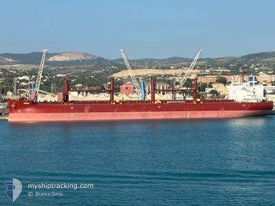
GENOA
Cargo
Current Trip
| Time Travelled | 15 h, 51 mins |
|---|---|
| Remaining Time | 1 day |
| Distance Travelled | 187.40 nm |
| Remaining Distance | 415.07 nm |
| AVG Speed | 11.6 Knots |
| MAX Speed | 13 Knots |
| AVG Wind | 7.7 knots |
| MAX Wind | 9.7 knots |
| MIN Temp | 26.6°C / 79.88°F |
| MAX Temp | 32.9°C / 91.22°F |
| Draught | 13 m |
| Position Received | 2025-11-12 02:21 |
Current Position
| Longitude | --- |
|---|---|
| Latitude | --- |
| Status | Under way using engine |
| Speed | 10.8 Knots |
| Course | 338° |
| Area | South Atlantic Ocean |
| Station | T-AIS |
| Position Received | 2025-11-12 02:21 |
Info
Information
The current position of GENOA is in South Atlantic Ocean with coordinates -32.34156° / 17.02710° as reported on 2025-11-12 02:21 by AIS to our vessel tracker app. The vessel's current speed is 10.8 Knots and is heading at the port of TAKORADI. The estimated time of arrival as calculated by MyShipTracking vessel tracking app is 2025-12-14 12:55 LT
The vessel GENOA (IMO: 9805659, MMSI: 248376000) is a Cargo It's sailing under the flag of [MT] Malta.
In this page you can find informations about the vessels current position, last detected port calls, and current voyage information. If the vessels is not in coverage by AIS you will find the latest position.
The current position of GENOA is detected by our AIS receivers and we are not responsible for the reliability of the data. The last position was recorded while the vessel was in Coverage by the Ais receivers of our vessel tracking app.
The current draught of GENOA as reported by AIS is 13 meters
Weather
| Temperature | 26.6°C / 79.88°F |
|---|---|
| Wind Speed | 9 knots |
| Direction | 204° SSW |
| Pressure | 1009.3 hPa |
| Humidity | 81.6 % |
| Cloud Coverage | 15 % |
Featured Company
Last Trips
Events
| Time | Event | Details | Position / Dest | Info |
|---|---|---|---|---|
| 2025-12-12 12:01 | PORT DEPARTURE |
|
4.66175 / 7.15236
GHTKD
|
Speed: 4.4 kn Course: 195° |
| 2025-12-12 11:33 | START Moving |
4.69419 / 7.15962
[NG] ONNE
|
Speed: 4 kn Course: 165° |
|
| 2025-12-10 17:13 | STOP Moving |
4.69839 / 7.15615
[NG] ONNE
|
Speed: 0.1 kn Course: 154° |
|
| 2025-12-10 17:05 | PORT ARRIVAL |
|
4.69811 / 7.15641
[NG] ONNE
|
Speed: 0.8 kn Course: 124° |
| 2025-12-10 14:53 | START Moving | 3.53 nm, North East of BONNY |
4.46856 / 7.17036
GHTKD
|
Speed: 5 kn Course: 19° |
| 2025-12-09 15:13 | STOP Moving | 3.5 nm, North East of BONNY |
4.46666 / 7.17214
GHTKD
|
Speed: 0.1 kn Course: 235° |
| 2025-12-09 11:49 | START Moving | 14.88 nm, South West of BONNY |
4.23116 / 6.97495
GHTKD
|
Speed: 3.9 kn Course: 95° |
| 2025-12-09 07:49 | STOP Moving | 14.32 nm, South West of BONNY |
4.23108 / 6.98980
GHTKD
|
Speed: 0.3 kn Course: 282° |
| 2025-12-06 21:05 | PORT DEPARTURE |
|
5.62983 / .02377
GHTKD
|
Speed: 3.9 kn Course: 79° |
| 2025-12-06 21:01 | START Moving |
5.62819 / .01683
[GH] TEMA
|
Speed: 3.9 kn Course: 79° |