

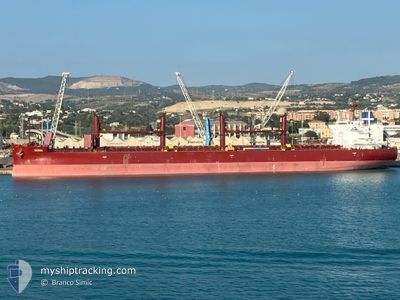
GENOA
Cargo

Current Trip
| Time Travelled | 2 days |
|---|---|
| Remaining Time | --- |
| Distance Travelled | 642.55 nm |
| Remaining Distance | --- |
| AVG Speed | 10.5 Noeuds |
| MAX Speed | 12.6 Noeuds |
| AVG Wind | 11.4 knots |
| MAX Wind | 20.7 knots |
| MIN Temp | 22.3°C / 72.14°F |
| MAX Temp | 25.5°C / 77.9°F |
| Tirant d eau | 7.4 m |
| Position reçue | 1 d depuis |
Current Position
| Longitude | --- |
|---|---|
| Latitude | --- |
| Etat | Under way using engine |
| Vitesse | 11.9 Noeuds |
| Parcours | 207° |
| Zone | South Atlantic Ocean |
| Station | T-AIS |
| Position reçue | 1 d depuis |
Information
The current position of GENOA is in South Atlantic Ocean with coordinates -28.70351° / -48.25902° as reported on 2025-03-20 00:39 by AIS to our vessel tracker app. The vessel's current speed is 11.9 Noeuds and is heading at the port of SAN LORENZO. The estimated time of arrival as calculated by MyShipTracking vessel tracking app is 2025-03-21 20:00 LT
The vessel GENOA (IMO: 9805659, MMSI: 248376000) is a Cargo It's sailing under the flag of [MT] Malta.
In this page you can find informations about the vessels current position, last detected port calls, and current voyage information. If the vessels is not in coverage by AIS you will find the latest position.
The current position of GENOA is detected by our AIS receivers and we are not responsible for the reliability of the data. The last position was recorded while the vessel was in Coverage by the Ais receivers of our vessel tracking app.
The current draught of GENOA as reported by AIS is 7.4 meters
Weather
| Temperature | 22.3°C / 72.14°F |
|---|---|
| Wind Speed | 8 knots |
| Direction | 19° NNE |
| Pressure | 1017.1 hPa |
| Humidity | 74.3 % |
| Cloud Coverage | --- |


Featured Company
Most Visited Ports (Last year)
| Port | Arrivals | |
|---|---|---|
| 2 | ||
| 2 | ||
| 1 | ||
| 1 | ||
| 1 | ||
| 1 |
Last Trips
Events
| Heure | Evenement | Détails | Position/ Destination | Info |
|---|---|---|---|---|
| 2025-03-20 00:46 | Etat Changé | Default Under way using engine |
-28.72442 / -48.27104
ARSLO
|
Vitesse: 11.9 kn Parcours: 207° |
| 2025-03-20 00:39 | Hors de la zone couverte |
-28.70351 / -48.25902
South Atlantic Ocean
ARSLO
|
Vitesse: 11.9 kn Parcours: 207° |
|
| 2025-03-20 00:16 | Etat Changé | Under way using engine Default |
-28.63498 / -48.22313
ARSLO
|
Vitesse: 11.8 kn Parcours: 200° |
| 2025-03-20 00:10 | Etat Changé | Default Under way using engine |
-28.61795 / -48.21511
ARSLO
|
Vitesse: 11.8 kn Parcours: 207.8° |
| 2025-03-19 12:52 | Etat Changé | Under way using engine Default |
-26.82273 / -47.45038
ARSLO
|
Vitesse: 10.3 kn Parcours: 195° |
| 2025-03-19 12:45 | Dans la zone couverte |
-26.82629 / -47.45188
South Atlantic Ocean
ARSLO
|
Vitesse: 10.4 kn Parcours: 200.8° |
|
| 2025-03-19 08:32 | Etat Changé | Default Under way using engine |
-26.15659 / -47.17108
ARSLO
|
Vitesse: 9 kn Parcours: 201.3° |
| 2025-03-19 08:26 | Etat Changé | Under way using engine Default |
-26.14198 / -47.16586
ARSLO
|
Vitesse: 9 kn Parcours: 196° |
| 2025-03-19 08:26 | Hors de la zone couverte |
-26.14198 / -47.16586
South Atlantic Ocean
ARSLO
|
Vitesse: 9 kn Parcours: 201.3° |
|
| 2025-03-19 08:22 | Etat Changé | Default Under way using engine |
-26.13125 / -47.16196
ARSLO
|
Vitesse: 9.3 kn Parcours: 201.2° |