
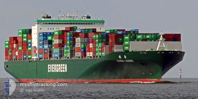
EVER LOGIC
Container Ship
Current Trip
| Time Travelled | 3 days |
|---|---|
| Remaining Time | 2 days |
| Distance Travelled | 918.03 nm |
| Remaining Distance | 1240.53 nm |
| AVG Speed | 15.5 Knots |
| MAX Speed | 20.1 Knots |
| AVG Wind | 12.1 knots |
| MAX Wind | 22 knots |
| MIN Temp | 25.8°C / 78.44°F |
| MAX Temp | 28.5°C / 83.3°F |
| Draught | 10.7 m |
| Position Received | 2 d ago |
Current Position
| Longitude | --- |
|---|---|
| Latitude | --- |
| Status | Under way using engine |
| Speed | 18.4 Knots |
| Course | 52.8° |
| Area | South China Sea |
| Station | T-AIS |
| Position Received | 2 d ago |
Info
Information
The current position of EVER LOGIC is in South China Sea with coordinates 1.62890° / 104.75209° as reported on 2025-12-23 23:37 by AIS to our vessel tracker app. The vessel's current speed is 18.4 Knots and is heading at the port of SHANGHAI. The estimated time of arrival as calculated by MyShipTracking vessel tracking app is 2025-12-29 05:46 LT
The vessel EVER LOGIC (IMO: 9604081, MMSI: 416482000) is a Container Ship that was built in 2013 ( 12 years old ). It's sailing under the flag of [TW] Taiwan.
In this page you can find informations about the vessels current position, last detected port calls, and current voyage information. If the vessels is not in coverage by AIS you will find the latest position.
The current position of EVER LOGIC is detected by our AIS receivers and we are not responsible for the reliability of the data. The last position was recorded while the vessel was in Coverage by the Ais receivers of our vessel tracking app.
The current draught of EVER LOGIC as reported by AIS is 10.7 meters
Weather
| Temperature | 24.9°C / 76.82°F |
|---|---|
| Wind Speed | 24 knots |
| Direction | 27° NNE |
| Pressure | 1011.9 hPa |
| Humidity | 76.4 % |
| Cloud Coverage | 100 % |
Featured Company
Last Port Calls
| Port | Arrival | Departure | Time In Port |
|---|---|---|---|
| 2025-12-22 23:18 | 2025-12-23 14:10 | 14 h | |
| 2025-12-11 20:08 | 2025-12-13 03:23 | 1 d | |
| 2025-12-06 00:33 | 2025-12-08 21:25 | 2 d | |
| 2025-12-02 00:16 | 2025-12-03 11:01 | 1 d | |
| 2025-11-23 11:30 | 2025-11-24 02:54 | 15 h | |
| 2025-11-17 08:11 | 2025-11-18 20:07 | 1 d | |
| 2025-11-14 16:03 | 2025-11-16 00:22 | 1 d | |
| 2025-11-06 12:56 | 2025-11-07 12:28 | 23 h | |
| 2025-10-28 04:40 | 2025-10-29 06:36 | 1 d | |
| 2025-10-16 07:34 | 2025-10-17 12:40 | 1 d |
Most Visited Ports (Last year)
| Port | Arrivals | |
|---|---|---|
| 5 | ||
| 5 | ||
| 5 | ||
| 4 | ||
| 4 | ||
| 4 |
Last Trips
| Origin | Departure | Destination | Arrival | Distance | |
|---|---|---|---|---|---|
| 2025-12-13 03:23 | 2025-12-22 23:18 | 3378.38 nm | |||
| 2025-12-08 21:25 | 2025-12-11 20:08 | 541.60 nm | |||
| 2025-12-03 11:01 | 2025-12-06 00:33 | 504.98 nm | |||
| 2025-11-24 02:54 | 2025-12-02 00:16 | 3360.22 nm | |||
| 2025-11-18 20:07 | 2025-11-23 11:30 | 1708.85 nm | |||
| 2025-11-16 00:22 | 2025-11-17 08:11 | 383.93 nm | |||
| 2025-11-07 12:28 | 2025-11-14 16:03 | 983.59 nm | |||
| 2025-10-29 06:36 | 2025-11-06 12:56 | 2492.92 nm | |||
| 2025-10-17 12:40 | 2025-10-28 04:40 | 3386.38 nm | |||
| 2025-10-15 01:12 | 2025-10-16 07:34 | 506.80 nm |
Events
| Time | Event | Details | Position / Dest | Info |
|---|---|---|---|---|
| 2025-12-23 23:42 | Status Changed | Default Under way using engine |
1.64421 / 104.76912
MYPKG > CNSHA
|
Speed: 18.4 kn Course: 52.8° |
| 2025-12-23 23:37 | OUT of Coverage |
1.62890 / 104.75209
South China Sea
MYPKG > CNSHA
|
Speed: 18.4 kn Course: 52.8° |
|
| 2025-12-23 21:42 | Change Sea Area | Malaysian part of the South China Sea Malaysian part of the Singapore Strait |
1.31886 / 104.35761
South China Sea
MYPKG > CNSHA
|
Speed: 14.1 kn Course: 48.1° |
| 2025-12-23 20:42 | Change Sea Area | Malaysian part of the Singapore Strait Indonesian part of the Singapore Strait |
1.25996 / 104.15007
Singapore Strait
MYPKG > CNSHA
|
Speed: 13.3 kn Course: 69° |
| 2025-12-23 20:40 | Status Changed | Under way using engine Default |
1.25656 / 104.14151
MYPKG > CNSHA
|
Speed: 13.1 kn Course: 66° |
| 2025-12-23 20:38 | Status Changed | Default Under way using engine |
1.25330 / 104.13430
MYPKG > CNSHA
|
Speed: 13.3 kn Course: 81.3° |
| 2025-12-23 18:21 | Draught Changed | 10.7 11.9 |
1.10604 / 103.74032
MYPKG > CNSHA
|
Speed: 12.1 kn Course: 38.8° |
| 2025-12-23 18:21 | Destination Changed | MYPKG > CNSHA AEJEA > MYPKG |
1.10604 / 103.74032
MYPKG > CNSHA
|
Speed: 12.1 kn Course: 38.8° |
| 2025-12-23 18:21 | ETA Changed | 2025/12/29 04:00 2025/12/20 23:00 |
1.10604 / 103.74032
MYPKG > CNSHA
|
Speed: 12.1 kn Course: 38.8° |
| 2025-12-23 17:55 | Change Sea Area | Indonesian part of the Singapore Strait Indonesian part of the South China Sea |
1.04424 / 103.67852
Singapore Strait
|
Speed: 12.1 kn Course: 51.4° |