
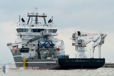
DEEP CYGNUS
Offshore Supply Ship
Current Trip
| Time Travelled | 3 days |
|---|---|
| Remaining Time | --- |
| Distance Travelled | 864.44 nm |
| Remaining Distance | --- |
| AVG Speed | 11.6 Knots |
| MAX Speed | 19.1 Knots |
| AVG Wind | 7.8 knots |
| MAX Wind | 22 knots |
| MIN Temp | -5.1°C / 22.82°F |
| MAX Temp | 8.7°C / 47.66°F |
| Draught | 5.9 m |
| Position Received | 17 h, 35 m ago |
Current Position
| Longitude | --- |
|---|---|
| Latitude | --- |
| Status | Under way using engine |
| Speed | 7 Knots |
| Course | 112° |
| Area | Irish Sea and St. George's Channel |
| Station | T-AIS |
| Position Received | 17 h, 35 m ago |
Info
Information
The current position of DEEP CYGNUS is in Irish Sea and St. George's Channel with coordinates 54.45825° / -4.40435° as reported on 2025-03-17 03:27 by AIS to our vessel tracker app. The vessel's current speed is 7 Knots
The vessel DEEP CYGNUS (IMO: 9479541, MMSI: 257205000) is a Offshore Supply Ship that was built in 2009 ( 16 years old ). It's sailing under the flag of [NO] Norway.
In this page you can find informations about the vessels current position, last detected port calls, and current voyage information. If the vessels is not in coverage by AIS you will find the latest position.
The current position of DEEP CYGNUS is detected by our AIS receivers and we are not responsible for the reliability of the data. The last position was recorded while the vessel was in Coverage by the Ais receivers of our vessel tracking app.
The current draught of DEEP CYGNUS as reported by AIS is 5.9 meters
Weather
| Temperature | 5.3°C / 41.54°F |
|---|---|
| Wind Speed | 12 knots |
| Direction | 82° E |
| Pressure | 1031.1 hPa |
| Humidity | 82.4 % |
| Cloud Coverage | 5 % |
Featured Company
Last Port Calls
| Port | Arrival | Departure | Time In Port |
|---|---|---|---|
| 2025-03-11 05:53 | 2025-03-13 23:38 | 2 d | |
| 2025-03-06 06:51 | 2025-03-06 11:53 | 5 h | |
| 2025-03-06 06:39 | 2025-03-06 06:48 | 8 m | |
| 2025-02-23 07:08 | 2025-02-24 16:25 | 1 d | |
| 2025-02-05 07:26 | 2025-02-05 14:36 | 7 h | |
| 2025-01-30 19:11 | 2025-01-30 19:38 | 27 m | |
| 2025-01-22 05:44 | 2025-01-22 13:34 | 7 h | |
| 2025-01-09 21:06 |
Most Visited Ports (Last year)
| Port | Arrivals | |
|---|---|---|
| 11 | ||
| 4 | ||
| 4 | ||
| 4 | ||
| 2 | ||
| 2 |
Last Trips
| Origin | Departure | Destination | Arrival | Distance | |
|---|---|---|---|---|---|
| 2025-03-06 11:53 | 2025-03-11 05:53 | 1049.48 nm | |||
| 2025-03-06 06:48 | 2025-03-06 06:51 | 0.77 nm | |||
| 2025-02-24 16:25 | 2025-03-06 06:39 | 2670.03 nm | |||
| 2025-02-05 14:36 | 2025-02-23 07:08 | 87.45 nm | |||
| 2025-01-30 19:38 | 2025-02-05 07:26 | 25.44 nm | |||
| 2025-01-22 13:34 | 2025-01-30 19:11 | 13.56 nm | |||
| 2025-01-09 21:06 | 2025-01-22 05:44 | 36.51 nm |
Events
| Time | Event | Details | Position / Dest | Info |
|---|---|---|---|---|
| 2025-03-17 03:27 | OUT of Coverage |
54.45825 / -4.40435
Irish Sea and St. George's Channel
GBBIF
|
Speed: 7 kn Course: 112° |
|
| 2025-03-17 02:22 | Detected in Sea | United Kingdom part of the Irish Sea and St. George's Channel |
54.50829 / -4.60248
Irish Sea and St. George's Channel
GBBIF
|
Speed: 6 kn Course: 114.6° |
| 2025-03-17 02:22 | IN Coverage |
54.50829 / -4.60248
Irish Sea and St. George's Channel
GBBIF
|
Speed: 6 kn Course: 114.6° |
|
| 2025-03-17 00:09 | OUT of Coverage |
54.61749 / -5.02035
Inner Seas off the West Coast of Scotland
GBBIF
|
Speed: 8.5 kn Course: 134.6° |
|
| 2025-03-16 20:06 | IN Coverage |
55.11995 / -5.79285
Inner Seas off the West Coast of Scotland
GBBIF
|
Speed: 10.6 kn Course: 140.6° |
|
| 2025-03-16 18:53 | OUT of Coverage |
55.30994 / -6.06672
Inner Seas off the West Coast of Scotland
GBBIF
|
Speed: 11.5 kn Course: 142.2° |
|
| 2025-03-16 18:36 | IN Coverage |
55.34851 / -6.12193
Inner Seas off the West Coast of Scotland
GBBIF
|
Speed: 10.7 kn Course: 124.2° |
|
| 2025-03-16 15:07 | OUT of Coverage |
55.69565 / -6.83760
Inner Seas off the West Coast of Scotland
GBBIF
|
Speed: 8.7 kn Course: 143.8° |
|
| 2025-03-16 13:41 | IN Coverage |
55.86505 / -7.10645
Inner Seas off the West Coast of Scotland
GBBIF
|
Speed: 10.8 kn Course: 139.5° |
|
| 2025-03-16 04:49 | OUT of Coverage |
57.44129 / -6.92678
Inner Seas off the West Coast of Scotland
GBBIF
|
Speed: 11.4 kn Course: 202.8° |