
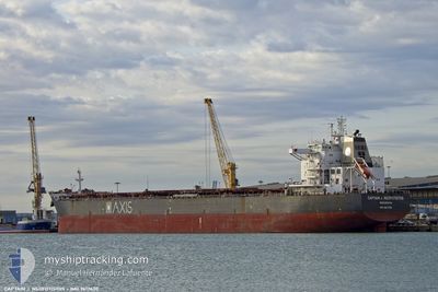
CAPTAINJ.NEOFOTISTOS
Bulk Carrier
Current Trip
HAZIRA
| Time Travelled | 4 days |
|---|---|
| Remaining Time | --- |
| Distance Travelled | 1014.98 nm |
| Remaining Distance | --- |
| AVG Speed | 10.5 Knots |
| MAX Speed | 11.9 Knots |
| AVG Wind | 6.3 knots |
| MAX Wind | 12 knots |
| MIN Temp | 25.6°C / 78.08°F |
| MAX Temp | 29.1°C / 84.38°F |
| Draught | 15.1 m |
| Position Received | Now |
Current Position
| Longitude | --- |
|---|---|
| Latitude | --- |
| Status | Under way using engine |
| Speed | 10.6 Knots |
| Course | 302.7° |
| Area | Laccadive Sea |
| Station | T-AIS |
| Position Received | Now |
Info
Information
The current position of CAPTAINJ.NEOFOTISTOS is in Laccadive Sea with coordinates 7.84113° / 77.22365° as reported on 2025-03-15 13:12 by AIS to our vessel tracker app. The vessel's current speed is 10.6 Knots
The vessel CAPTAINJ.NEOFOTISTOS (IMO: 9617430, MMSI: 636016657) is a Bulk Carrier that was built in 2012 ( 13 years old ). It's sailing under the flag of [LR] Liberia.
In this page you can find informations about the vessels current position, last detected port calls, and current voyage information. If the vessels is not in coverage by AIS you will find the latest position.
The current position of CAPTAINJ.NEOFOTISTOS is detected by our AIS receivers and we are not responsible for the reliability of the data. The last position was recorded while the vessel was in Coverage by the Ais receivers of our vessel tracking app.
The current draught of CAPTAINJ.NEOFOTISTOS as reported by AIS is 15.1 meters
Weather
| Temperature | 28.5°C / 83.3°F |
|---|---|
| Wind Speed | 7 knots |
| Direction | 116° ESE |
| Pressure | 1009.8 hPa |
| Humidity | 71.3 % |
| Cloud Coverage | 7 % |
Featured Company
Last Port Calls
| Port | Arrival | Departure | Time In Port |
|---|---|---|---|
| 2025-03-09 20:24 | 2025-03-11 16:55 | 1 d | |
| 2025-03-04 23:21 | 2025-03-08 01:24 | 3 d |
Most Visited Ports (Last year)
| Port | Arrivals | |
|---|---|---|
| 2 | ||
| 2 | ||
| 1 | ||
| 1 | ||
| 1 | ||
| 1 |
Last Trips
| Origin | Departure | Destination | Arrival | Distance | |
|---|---|---|---|---|---|
| 2025-03-08 01:24 | 2025-03-09 20:24 | 471.06 nm |
Events
| Time | Event | Details | Position / Dest | Info |
|---|---|---|---|---|
| 2025-03-15 08:49 | Status Changed | Under way using engine Default |
7.41620 / 77.85815
HAZIRA
|
Speed: 10.1 kn Course: 300° |
| 2025-03-15 08:36 | Status Changed | Default Under way using engine |
7.39648 / 77.88889
HAZIRA
|
Speed: 10.2 kn Course: 301.6° |
| 2025-03-15 08:34 | Detected in Sea | Indian part of the Laccadive Sea |
7.39373 / 77.89333
Laccadive Sea
HAZIRA
|
Speed: 10.2 kn Course: 301.6° |
| 2025-03-15 08:34 | Status Changed | Under way using engine Default |
7.39373 / 77.89333
HAZIRA
|
Speed: 10.2 kn Course: 303° |
| 2025-03-15 08:21 | IN Coverage |
7.39373 / 77.89333
Laccadive Sea
HAZIRA
|
Speed: 10.2 kn Course: 301.6° |
|
| 2025-03-14 17:09 | Status Changed | Default Under way using engine |
5.95913 / 80.05426
HAZIRA
|
Speed: 10.6 kn Course: 294.3° |
| 2025-03-14 17:04 | OUT of Coverage |
5.95304 / 80.06668
Laccadive Sea
HAZIRA
|
Speed: 10.6 kn Course: 294.3° |
|
| 2025-03-14 16:58 | Status Changed | Under way using engine Default |
5.94588 / 80.08137
HAZIRA
|
Speed: 10.9 kn Course: 293° |
| 2025-03-14 16:48 | Status Changed | Default Under way using engine |
5.93214 / 80.10989
HAZIRA
|
Speed: 11.1 kn Course: 295.2° |
| 2025-03-14 16:37 | Status Changed | Under way using engine Default |
5.91820 / 80.13886
HAZIRA
|
Speed: 11.2 kn Course: 295° |