
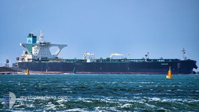
CAESAR
Crude Oil Tanker
Current Trip
AE JBN
| Time Travelled | 47 days |
|---|---|
| Remaining Time | --- |
| Distance Travelled | 9471.43 nm |
| Remaining Distance | --- |
| AVG Speed | 11.6 Knots |
| MAX Speed | 20.2 Knots |
| AVG Wind | 8.1 knots |
| MAX Wind | 27 knots |
| MIN Temp | 24.4°C / 75.92°F |
| MAX Temp | 32.2°C / 89.96°F |
| Draught | 11 m |
| Position Received | 16 h, 28 m ago |
Current Position
| Longitude | 76.55757° |
|---|---|
| Latitude | 7.72533° |
| Status | Under way using engine |
| Speed | 14.6 Knots |
| Course | 303° |
| Area | Laccadive Sea |
| Station | T-AIS |
| Position Received | 16 h, 28 m ago |
Info
Information
The current position of CAESAR is in Laccadive Sea with coordinates 7.72533° / 76.55757° as reported on 2024-05-26 01:19 by AIS to our vessel tracker app. The vessel's current speed is 14.6 Knots
The vessel CAESAR (IMO: 9389265, MMSI: 249838000) is a Crude Oil Tanker that was built in 2009 ( 15 years old ). It's sailing under the flag of [MT] Malta.
In this page you can find informations about the vessels current position, last detected port calls, and current voyage information. If the vessels is not in coverage by AIS you will find the latest position.
The current position of CAESAR is detected by our AIS receivers and we are not responsible for the reliability of the data. The last position was recorded while the vessel was in Coverage by the Ais receivers of our vessel tracking app.
The current draught of CAESAR as reported by AIS is 11 meters
Weather
| Temperature | 29.9°C / 85.82°F |
|---|---|
| Wind Speed | 13 knots |
| Direction | 288° WNW |
| Pressure | 1007.4 hPa |
| Humidity | 81.3 % |
| Cloud Coverage | 100 % |
Featured Company
Last Port Calls
| Port | Arrival | Departure | Time In Port |
|---|---|---|---|
| 2024-04-08 12:05 | 2024-04-09 06:24 | 18 h |
Most Visited Ports (Last year)
| Port | Arrivals | |
|---|---|---|
| 1 |
Last Trips
| Origin | Departure | Destination | Arrival | Distance |
|---|
Events
| Time | Event | Details | Position / Dest | Info |
|---|---|---|---|---|
| 2024-05-26 01:36 | Status Changed | Default Under way using engine |
7.76290 / 76.49921
AE JBN
|
Speed: 14.6 kn Course: 303° |
| 2024-05-26 01:19 | OUT of Coverage |
7.72533 / 76.55757
Laccadive Sea
AE JBN
|
Speed: 14.6 kn Course: 303° |
|
| 2024-05-25 23:54 | Status Changed | Under way using engine Default |
7.53202 / 76.84668
AE JBN
|
Speed: 13.8 kn Course: 302° |
| 2024-05-25 23:34 | Status Changed | Default Under way using engine |
7.48872 / 76.91421
AE JBN
|
Speed: 13.7 kn Course: 302° |
| 2024-05-25 23:33 | Status Changed | Under way using engine Default |
7.48762 / 76.91590
AE JBN
|
Speed: 13.8 kn Course: 303° |
| 2024-05-25 23:27 | Status Changed | Default Under way using engine |
7.47420 / 76.93662
AE JBN
|
Speed: 13.6 kn Course: 303° |
| 2024-05-25 22:49 | Status Changed | Under way using engine Default |
7.39250 / 77.06120
AE JBN
|
Speed: 13.3 kn Course: 300° |
| 2024-05-25 22:33 | Status Changed | Default Under way using engine |
7.36068 / 77.11508
AE JBN
|
Speed: 13.4 kn Course: 301° |
| 2024-05-25 22:29 | Status Changed | Under way using engine Default |
7.35298 / 77.12787
AE JBN
|
Speed: 13.6 kn Course: 300° |
| 2024-05-25 22:02 | Status Changed | Default Under way using engine |
7.29723 / 77.22180
AE JBN
|
Speed: 13.8 kn Course: 311° |