
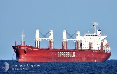
BERGE JUNGFRAU
Other Type
Current Trip
| Time Travelled | 15 days |
|---|---|
| Remaining Time | 2 h, 49 mins |
| Distance Travelled | 4350.44 nm |
| Remaining Distance | 52.45 nm |
| AVG Speed | 11.6 Knots |
| MAX Speed | 15.3 Knots |
| AVG Wind | 11.7 knots |
| MAX Wind | 32.8 knots |
| MIN Temp | 15.3°C / 59.54°F |
| MAX Temp | 30.8°C / 87.44°F |
| Draught | 9.8 m |
| Position Received | 1 d ago |
Current Position
| Longitude | 123.11608° |
|---|---|
| Latitude | 27.17724° |
| Status | Under way using engine |
| Speed | 11.9 Knots |
| Course | 9.3° |
| Area | Eastern China Sea |
| Station | T-AIS |
| Position Received | 1 d ago |
Info
Information
The current position of BERGE JUNGFRAU is in Eastern China Sea with coordinates 27.17724° / 123.11608° as reported on 2024-05-11 08:17 by AIS to our vessel tracker app. The vessel's current speed is 11.9 Knots and is heading at the port of DONGJIAKOU. The estimated time of arrival as calculated by MyShipTracking vessel tracking app is 2024-05-13 10:05 LT
The vessel BERGE JUNGFRAU (IMO: 9846304, MMSI: 538008162) is a Other Type It's sailing under the flag of [MH] Marshall Is.
In this page you can find informations about the vessels current position, last detected port calls, and current voyage information. If the vessels is not in coverage by AIS you will find the latest position.
The current position of BERGE JUNGFRAU is detected by our AIS receivers and we are not responsible for the reliability of the data. The last position was recorded while the vessel was in Coverage by the Ais receivers of our vessel tracking app.
The current draught of BERGE JUNGFRAU as reported by AIS is 9.8 meters
Weather
| Temperature | 18.1°C / 64.58°F |
|---|---|
| Wind Speed | 9 knots |
| Direction | 136° SE |
| Pressure | 1015 hPa |
| Humidity | 69.2 % |
| Cloud Coverage | --- |
Featured Company
Most Visited Ports (Last year)
| Port | Arrivals | |
|---|---|---|
| 2 | ||
| 2 | ||
| 2 | ||
| 2 | ||
| 2 | ||
| 1 |
Events
| Time | Event | Details | Position / Dest | Info |
|---|---|---|---|---|
| 2024-05-11 08:23 | Status Changed | Default Under way using engine |
27.19667 / 123.11833
CN DJK
|
Speed: 11.9 kn Course: 9.3° |
| 2024-05-11 08:17 | OUT of Coverage |
27.17724 / 123.11608
Eastern China Sea
CN DJK
|
Speed: 11.9 kn Course: 9.3° |
|
| 2024-05-11 07:42 | Status Changed | Under way using engine Default |
27.06538 / 123.09550
CN DJK
|
Speed: 11.8 kn Course: 10° |
| 2024-05-11 07:20 | Status Changed | Default Under way using engine |
26.99366 / 123.08187
CN DJK
|
Speed: 11.8 kn Course: 11.1° |
| 2024-05-11 07:02 | Status Changed | Under way using engine Default |
26.93540 / 123.07063
CN DJK
|
Speed: 11.8 kn Course: 11° |
| 2024-05-11 06:10 | Status Changed | Default Under way using engine |
26.77017 / 123.04766
CN DJK
|
Speed: 11.6 kn Course: 7.7° |
| 2024-05-11 06:06 | Change Sea Area | Conflict Zone part of the Eastern China Sea Australian part of the Indian Ocean |
26.75489 / 123.04507
Eastern China Sea
CN DJK
|
Speed: 11.6 kn Course: 7.7° |
| 2024-05-11 06:06 | Status Changed | Under way using engine Default |
26.75489 / 123.04507
CN DJK
|
Speed: 11.4 kn Course: 7° |
| 2024-05-11 05:51 | IN Coverage |
26.75489 / 123.04507
Eastern China Sea
CN DJK
|
Speed: 11.6 kn Course: 7.7° |