

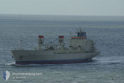
BALTIC SUMMER
Reefer
Current Trip
| Time Travelled | 25 days |
|---|---|
| Remaining Time | --- |
| Distance Travelled | 8183.67 nm |
| Remaining Distance | --- |
| AVG Speed | 16.7 Knots |
| MAX Speed | 21 Knots |
| AVG Wind | 15.3 knots |
| MAX Wind | 28 knots |
| MIN Temp | -5.2°C / 22.64°F |
| MAX Temp | 30.3°C / 86.54°F |
| Draught | 8.5 m |
| Position Received | 5 d ago |
Current Position
| Longitude | --- |
|---|---|
| Latitude | --- |
| Status | Under way using engine |
| Speed | 19 Knots |
| Course | 190° |
| Area | North Pacific Ocean |
| Station | T-AIS |
| Position Received | 5 d ago |
Information
The current position of BALTIC SUMMER is in North Pacific Ocean with coordinates 6.17394° / -79.78744° as reported on 2025-02-28 17:55 by AIS to our vessel tracker app. The vessel's current speed is 19 Knots and is heading at the port of CHANCAY. The estimated time of arrival as calculated by MyShipTracking vessel tracking app is 2025-03-03 07:00 LT
The vessel BALTIC SUMMER (IMO: 8802090, MMSI: 311000992) is a Reefer that was built in 1989 ( 36 years old ). It's sailing under the flag of [BS] Bahamas.
In this page you can find informations about the vessels current position, last detected port calls, and current voyage information. If the vessels is not in coverage by AIS you will find the latest position.
The current position of BALTIC SUMMER is detected by our AIS receivers and we are not responsible for the reliability of the data. The last position was recorded while the vessel was in Coverage by the Ais receivers of our vessel tracking app.
The current draught of BALTIC SUMMER as reported by AIS is 8.5 meters
Weather
| Temperature | 20.9°C / 69.62°F |
|---|---|
| Wind Speed | 3 knots |
| Direction | 188° S |
| Pressure | 1013.1 hPa |
| Humidity | 84.2 % |
| Cloud Coverage | 67 % |
Featured Company
Last Port Calls
| Port | Arrival | Departure | Time In Port |
|---|---|---|---|
| 2025-02-08 05:29 | 2025-02-09 09:16 | 1 d | |
| 2025-02-01 15:28 | 2025-02-07 14:33 | 5 d | |
| 2025-01-28 04:13 | 2025-02-01 08:50 | 4 d | |
| 2025-01-21 12:58 | 2025-01-22 20:42 | 1 d | |
| 2025-01-01 16:49 | 2025-01-07 16:36 | 5 d |
Most Visited Ports (Last year)
| Port | Arrivals | |
|---|---|---|
| 6 | ||
| 3 | ||
| 3 | ||
| 1 | ||
| 1 | ||
| 1 |
Last Trips
| Origin | Departure | Destination | Arrival | Distance | |
|---|---|---|---|---|---|
| 2025-02-07 17:33 | 2025-02-08 08:29 | 70.59 nm | |||
| 2025-02-01 11:50 | 2025-02-01 18:28 | 62.86 nm | |||
| 2025-01-22 21:42 | 2025-01-28 07:13 | 1975.33 nm | |||
| 2025-01-07 11:36 | 2025-01-21 13:58 | 5151.23 nm | |||
| 2024-12-30 17:10 | 2025-01-01 11:49 | 745.44 nm |
Events
| Time | Event | Details | Position / Dest | Info |
|---|---|---|---|---|
| 2025-03-03 11:34 | STOP Moving | 0.83 nm, South of CHANCAY |
-11.59677 / -77.27765
CHANCAY, PERU
|
Speed: Course: 46° |
| 2025-02-28 18:01 | Status Changed | Default Under way using engine |
6.13685 / -79.79441
CHANCAY, PERU
|
Speed: 19 kn Course: 190° |
| 2025-02-28 17:55 | OUT of Coverage |
6.17394 / -79.78744
North Pacific Ocean
CHANCAY, PERU
|
Speed: 19 kn Course: 190° |
|
| 2025-02-28 15:26 | Status Changed | Under way using engine Default |
6.98234 / -79.63489
CHANCAY, PERU
|
Speed: 20.3 kn Course: 192° |
| 2025-02-28 15:22 | Status Changed | Default Under way using engine |
7.00175 / -79.63057
CHANCAY, PERU
|
Speed: 20 kn Course: 194° |
| 2025-02-28 15:03 | Status Changed | Under way using engine Default |
7.10618 / -79.60330
CHANCAY, PERU
|
Speed: 20 kn Course: 195° |
| 2025-02-28 14:45 | IN Coverage |
7.10618 / -79.60330
North Pacific Ocean
CHANCAY, PERU
|
Speed: 20 kn Course: 195° |
|
| 2025-02-28 11:10 | Status Changed | Default Under way using engine |
8.41310 / -79.46432
CHANCAY, PERU
|
Speed: 19.9 kn Course: 180.9° |
| 2025-02-28 11:06 | OUT of Coverage |
8.43971 / -79.46378
North Pacific Ocean
CHANCAY, PERU
|
Speed: 19.9 kn Course: 180.9° |
|
| 2025-02-28 10:23 | Status Changed | Under way using engine Default |
8.66598 / -79.45964
CHANCAY, PERU
|
Speed: 17.7 kn Course: 182° |