
BALTIC SUMMER
Reefer
Current Trip
| Time Travelled | 9 days |
|---|---|
| Remaining Time | --- |
| Distance Travelled | 3758.38 nm |
| Remaining Distance | --- |
| AVG Speed | 16.6 Knopen |
| MAX Speed | 19.4 Knopen |
| AVG Wind | 11.5 knots |
| MAX Wind | 23 knots |
| MIN Temp | 16.3°C / 61.34°F |
| MAX Temp | 28.9°C / 84.02°F |
| Diepgang | 8.7 M |
| Positie ontvangen | 8 d geleden |
Current Position
| Lengtegraad | -54.82908° |
|---|---|
| Breedtegraat | -35.09199° |
| Status | Under way using engine |
| Snelheid | 15.5 Knopen |
| Koers | 91.8° |
| Gebied | South Atlantic Ocean |
| Station | T-AIS |
| Positie ontvangen | 8 d geleden |
Info
Information
The current position of BALTIC SUMMER is in South Atlantic Ocean with coordinates -35.09199° / -54.82908° as reported on 2024-05-05 13:38 by AIS to our vessel tracker app. The vessel's current speed is 15.5 Knopen and is heading at the port of VENE BALTI. The estimated time of arrival as calculated by MyShipTracking vessel tracking app is 2024-05-23 06:00 LT
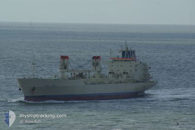
The vessel BALTIC SUMMER (IMO: 8802090, MMSI: 311000992) is a Reefer that was built in 1989 ( 35 Jaar oud ). It's sailing under the flag of [BS] Bahamas.
In this page you can find informations about the vessels current position, last detected port calls, and current voyage information. If the vessels is not in coverage by AIS you will find the latest position.
The current position of BALTIC SUMMER is detected by our AIS receivers and we are not responsible for the reliability of the data. The last position was recorded while the vessel was in Coverage by the Ais receivers of our vessel tracking app.
The current draught of BALTIC SUMMER as reported by AIS is 8.7 meters
Weather
| Temperature | 23.1°C / 73.58°F |
|---|---|
| Wind Speed | 17 knots |
| Direction | 41° NE |
| Pressure | 1014.8 hPa |
| Humidity | 84 % |
| Cloud Coverage | 43 % |
Featured Company
Last Port Calls
| Port | Arrival | Departure | Time In Port |
|---|---|---|---|
| 2024-04-24 17:49 | 2024-05-04 16:22 | 9 d | |
| 2024-03-24 07:57 | 2024-03-28 22:47 | 4 d |
Most Visited Ports (Last year)
| Port | Arrivals | |
|---|---|---|
| 4 | ||
| 2 | ||
| 2 | ||
| 1 | ||
| 1 | ||
| 1 |
Last Trips
| Origin | Departure | Destination | Arrival | Distance | |
|---|---|---|---|---|---|
| 2024-03-29 01:47 | 2024-04-24 14:49 | 7954.94 nm | |||
| 2024-02-25 13:29 | 2024-03-24 10:57 | 7747.61 nm |
Events
| Tijd | Evenement | Details | Positie / Bestemming | Info |
|---|---|---|---|---|
| 2024-05-10 07:57 | Start beweging |
-9.45388 / -34.68882
TALLINN
|
Snelheid: 3.1 kn Koers: 11° |
|
| 2024-05-05 13:44 | Status Changed | Default Under way using engine |
-35.09244 / -54.79675
TALLINN
|
Snelheid: 15.5 kn Koers: 91.8° |
| 2024-05-05 13:38 | Buitenbereik |
-35.09199 / -54.82908
South Atlantic Ocean
TALLINN
|
Snelheid: 15.5 kn Koers: 91.8° |
|
| 2024-05-05 12:50 | Wijzig zee gebeid | Uruguayan part of the South Atlantic Ocean Uruguayan part of the Rio de La Plata |
-35.05033 / -55.07303
South Atlantic Ocean
TALLINN
|
Snelheid: 15.1 kn Koers: 99.9° |
| 2024-05-05 11:26 | Wijzig zee gebeid | Uruguayan part of the Rio de La Plata Argentinean part of the Rio de La Plata |
-35.05838 / -55.50507
Rio de La Plata
TALLINN
|
Snelheid: 15.3 kn Koers: 82.5° |
| 2024-05-05 11:25 | Status Changed | Under way using engine Default |
-35.05844 / -55.50567
TALLINN
|
Snelheid: 15.3 kn Koers: 86° |
| 2024-05-05 11:12 | Binnenbereik |
-35.05838 / -55.50507
Rio de La Plata
TALLINN
|
Snelheid: 15.3 kn Koers: 82.5° |
|
| 2024-05-04 21:13 | Status Changed | Default Under way using engine |
-34.61324 / -58.22992
TALLINN
|
Snelheid: 10.6 kn Koers: 127.7° |
| 2024-05-04 21:11 | Buitenbereik |
-34.61099 / -58.23674
Rio de La Plata
TALLINN
|
Snelheid: 10.6 kn Koers: 127.7° |
|
| 2024-05-04 17:42 | Status Changed | Under way using engine Default |
-34.23799 / -58.76742
TALLINN
|
Snelheid: 7.7 kn Koers: 104° |